Pertek
Pertek (Kurdish: Pêrteg,[3] Armenian: Բերդակ) is a small city and its surrounding district in Tunceli Province of modern Turkey. Pertag, means "tiny fortress" in Armenian.
Pertek | |
|---|---|
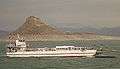
 View of Pertek, the 16th century Celebi Ali mosque is visible in the left of the image. In the background is lake Keban. | |
 Pertek | |
| Coordinates: 38°52′01″N 39°19′30″E | |
| Country | |
| Province | Tunceli |
| Government | |
| • Mayor | Ruhan Alan (CHP) |
| • Kaymakam | Arif Gül |
| Area | |
| • District | 945.02 km2 (364.87 sq mi) |
| Population (2012)[2] | |
| • Urban | 7,077 |
| • District | 12,198 |
| • District density | 13/km2 (33/sq mi) |
| Post code | 62500 |
| Climate | Csa |
| Website | www.pertek.bel.tr |
| Wikimedia Commons has media related to Pertek. |
The area of Pertek was ruled by different empires in its history. In the medieval period such as the Armenians and Byzantines before being taken over by different Islamic dynasties after the 11th century. Later it became part of the Ilkhanids and others and finally became part of the Ottoman Empire in the early 16th century. During the Ottoman period Pertek was a hereditary Kurdish sanjak.[4] The old town of Pertek was located near the citadel but was abandoned in 1838 and moved to its current location.[4] Before the Armenian genocide it was populated by Armenians, Turks and Kurds. Today the city is populated by Turks and Kurds. The mayor is Ruhan Alan from the Republican People's Party (CHP).[5] Kaymakam is Arif Gül.[6] The city has a population of 6,341.
Historic monuments
There are two historic Ottoman mosques in Pertek.[4]The Baysungur mosque (16th century)[4] and Celebi Ali mosque (16th century).[4] The mosques were later dismantled and moved from the site of the old town to protect them from the rising water shore of the Lake Keban.[4] The Pertek Castle is located on an Island.[4] There are other historic sights in the nearby area. The village of Sağman has a ruined citadel with a 16th-century mosque, tomb and tekke built by the Kurdish sanjak bey Keykusrav.[4]
 The Pertek Castle is located on an island since the building of the Keban Dam.
References
- "Area of regions (including lakes), km²". Regional Statistics Database. Turkish Statistical Institute. 2002. Retrieved 2013-03-05.
- "Population of province/district centers and towns/villages by districts - 2012". Address Based Population Registration System (ABPRS) Database. Turkish Statistical Institute. Retrieved 2013-02-27.
- adem Avcıkıran (2009). Kürtçe Anamnez Anamneza bi Kurmancî (PDF) (in Turkish and Kurdish). p. 55. Retrieved 17 December 2019.
- Sinclair, T.A. (1989). Eastern Turkey: An Architectural & Archaeological Survey, Volume I. Pindar Press. pp. 77-83-84-85-102-103-158. ISBN 9780907132325.
- Şafak, Yeni (2019-06-12). "Tunceli Pertek Seçim Sonuçları – Pertek Yerel Seçim Sonuçları". Yeni Şafak (in Turkish). Retrieved 2019-12-06.
- "Pertek Kaymakamı Arif GÜL". www.pertek.gov.tr. Retrieved 2019-12-06.
Pertek in Tunceli Province of Turkey | |||||||||||||||||||||||||||
|---|---|---|---|---|---|---|---|---|---|---|---|---|---|---|---|---|---|---|---|---|---|---|---|---|---|---|---|
| Districts | 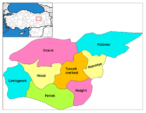 Districts of Tunceli | ||||||||||||||||||||||||||
| |||||||||||||||||||||||||||
Metropolitan municipalities are bolded. | |||||||||||||||||||||||||||