Camperdown, New South Wales
Camperdown is an inner western suburb of Sydney, in the state of New South Wales, Australia. Camperdown is located 4 kilometres south-west of the Sydney central business district and is part of the Inner West region. Camperdown lies across the local government areas of the City of Sydney and Inner West Council.
| Camperdown Sydney, New South Wales | |||||||||||||||
|---|---|---|---|---|---|---|---|---|---|---|---|---|---|---|---|
 A view of rooftops in Camperdown | |||||||||||||||
| Population | 10,341 (2016 census)[1] | ||||||||||||||
| • Density | 4,362.7/km2 (11,299/sq mi) | ||||||||||||||
| Postcode(s) | 2050 | ||||||||||||||
| Area | 1.5 km2 (0.6 sq mi) | ||||||||||||||
| Location | 4 km (2 mi) SW of Sydney CBD | ||||||||||||||
| LGA(s) | |||||||||||||||
| State electorate(s) | |||||||||||||||
| Federal Division(s) | |||||||||||||||
| |||||||||||||||
Camperdown is a heavily populated suburb and is home to the Royal Prince Alfred Hospital, the University of Sydney and the historic Camperdown Cemetery. It was also once home to the Royal Alexandra Hospital for Children, which was relocated to be next to Westmead Hospital in Sydney's west. The hospital buildings and grounds have been redeveloped into apartment complexes.

 RPA Albert Pavilion
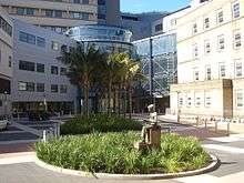 Royal Prince Alfred Hospital
History
Camperdown takes its name from the Battle of Camperdown (or Camperduin in Dutch). It was named by Governor William Bligh who received a grant of 240 acres (1 km²) of land covering present day Camperdown and parts of Newtown. The land passed to Bligh's son-in-law Maurice O'Connell, commander of the 73rd Regiment, later Sir Maurice, when Bligh returned to England.[2] Camperdown was established as a residential and farming area in the early 19th century.
In 1827, a racecourse was opened on land where the Royal Prince Alfred Hospital now stands. The University of Sydney was incorporated in 1850 and its first buildings were designed by Edmund Blacket (1817–1883). In 1859, Blacket's Great Hall was opened at the university.[3]
Heritage listings
Camperdown has a number of heritage-listed sites, including:
- 10, 14 Australia Street: Cranbrook[4]
- Missenden Road: Admission Block, Royal Prince Alfred Hospital [5]
- Missenden Road: Victoria & Albert Pavilions, Royal Prince Alfred Hospital[6]
- Corner of Parramatta and City Roads: Victoria Park[7]
Demographics
According to the 2016 census of Population, there were 10,341 residents in Camperdown. In Camperdown, 52.4% of people were born in Australia. The next most common countries of birth were China 9.3%, England 4.6%, New Zealand 2.6%, Malaysia 1.4% and United States of America 1.2%. 64.9% of people only spoke English at home. Other languages spoken at home included Mandarin 9.5% and Cantonese 2.4%. The most common responses for religion were No Religion 51.2% and Catholic 14.8%.[1]
Education
A large part of Camperdown is taken up by the University of Sydney and the residential colleges within the university. These colleges include: St John's College, St Andrew's College, St Paul's College, Sancta Sophia College, Wesley College and The Women's College.
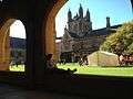 Main Quadrangle, University of Sydney
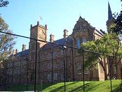 St Andrew's College, University of Sydney
 The Women's College, University of Sydney
Houses
In common with neighbouring inner city suburbs such as Newtown and Enmore, Camperdown has large areas of Victorian terraced housing, including many examples of single storey terraces. There are several examples of semi-detached houses which became popular around the time of Australia's Federation at the turn of the 20th century. With the advent of gentrification, from the late 20th century, modern infill development now tends to be sympathetic with the traditional Victorian and Edwardian streetscapes.[8]
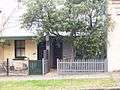 Modest terraced homes
 Weatherboard terraces
 Former corner store
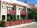 Infill
Parks

Victoria Park is located on the corner of Parramatta Road and City Road, adjacent to the University of Sydney.
Camperdown Park is surrounded by Mallett, Pidcock, Fowler and Australia Streets and includes several sports grounds and an urban farm.[9]
Transport
Roads
Parramatta Road (A22) is a major transport artery between Sydney and Parramatta. It runs across the northern side of Camperdown. City Road (A36) is part of a major route to the southern suburbs of Sydney. It meets Parramatta Road and Broadway at a major intersection on the eastern tip of Camperdown. Both City Road and Parramatta Road had tram services until the late 1950s.
In popular culture
The suburb is mentioned in the song "Australia Street" by the band Sticky Fingers, featuring on their 2013 album Caress Your Soul.
Notable people
- Mile Jedinak, footballer
- Beverly Robertson, Lions Australia
References
- Australian Bureau of Statistics (27 June 2017). "Camperdown (NSW) (State Suburb)". 2016 Census QuickStats. Retrieved 21 December 2017.

- Dando-Collins, Captain Bligh's Other Mutiny, Random House, Sydney, 2007, ISBN 978-1-74166-798-1
- The Book of Sydney Suburbs, Compiled by Frances Pollon, Angus & Robertson Publishers, 1990, Published in Australia ISBN 0-207-14495-8
- "Cranbrook Group". New South Wales State Heritage Register. Office of Environment and Heritage. H00418. Retrieved 18 May 2018.
- "Royal Prince Alfred Hospital - Admission Block". New South Wales State Heritage Register. Office of Environment and Heritage. H00830. Retrieved 18 May 2018.
- "Royal Prince Alfred Hospital - Victoria & Albert Pavilions". New South Wales State Heritage Register. Office of Environment and Heritage. H00829. Retrieved 18 May 2018.
- "The University of Sydney, University Colleges and Victoria Park". New South Wales State Heritage Register. Office of Environment and Heritage. H01974. Retrieved 21 December 2019.
- "About Camperdown". Retrieved 20 January 2017.
- "Camperdown Park". Inner West Council. Retrieved 11 January 2020.
External links
| Wikimedia Commons has media related to Camperdown, New South Wales. |