Parapet Peak
Parapet Peak is located on the border of Alberta and British Columbia. It was named in 1921 by Cyril G. Wates.[1][2]
| Parapet Peak | |
|---|---|
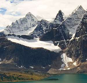 Parapet Peak is the dark peak between Bennington Peak (left), and Paragon Peak (right) | |
| Highest point | |
| Elevation | 3,031 m (9,944 ft) [1] |
| Prominence | 177 m (581 ft) |
| Coordinates | 52°40′01″N 118°17′39″W |
| Geography | |
 Parapet Peak Location in Alberta and British Columbia  Parapet Peak Parapet Peak (Canada) | |
| Location | Alberta British Columbia |
| Parent range | Park Ranges |
| Topo map | NTS 83D/09 |
Climate
Based on the Köppen climate classification, the mountain is located in a subarctic climate with cold, snowy winters, and mild summers.[3] Temperatures can drop below -20 °C with wind chill factors below -30 °C. In terms of favorable weather, July and August present the best months for climbing. However, these months coincide with mosquito season, which requires effective defenses. Precipitation runoff from the mountain drains into tributaries of the Athabasca River on its east side, and the headwaters of the Fraser River from the west side.
See also
- List of peaks on the British Columbia-Alberta border
- Mountains of Alberta
- Mountains of British Columbia
References
- PeakFinder
- Parapet Peak
- Peel, M. C.; Finlayson, B. L. & McMahon, T. A. (2007). "Updated world map of the Köppen−Geiger climate classification". Hydrol. Earth Syst. Sci. 11: 1633–1644. ISSN 1027-5606.
External links
Bennington Peak with Parapet Peak (right): Flickr (photo)
This article is issued from Wikipedia. The text is licensed under Creative Commons - Attribution - Sharealike. Additional terms may apply for the media files.