Oodnadatta
Oodnadatta is a small, remote outback town and locality in the Australian state of South Australia, located about 873 kilometres (542 mi) north of the state capital of Adelaide (over 873 kilometres (542 mi) by road) and 112 m above sea level.
| Oodnadatta South Australia | |||||||||||||||
|---|---|---|---|---|---|---|---|---|---|---|---|---|---|---|---|
 The Pink Roadhouse at Oodnadatta | |||||||||||||||
 Oodnadatta | |||||||||||||||
| Coordinates | 27°32′53″S 135°26′44″E[1] | ||||||||||||||
| Population | 204 (shared with other localities) (2016 census)[2][lower-alpha 1] | ||||||||||||||
| Established | 30 October 1890 (town) 8 February 2001 (locality)[3][1] | ||||||||||||||
| Postcode(s) | 5734[4] | ||||||||||||||
| Elevation | 121 m (397 ft)(railway station)[5] | ||||||||||||||
| Time zone | ACST (UTC+9:30) | ||||||||||||||
| • Summer (DST) | ACST (UTC+10:30) | ||||||||||||||
| Location |
| ||||||||||||||
| LGA(s) | Pastoral Unincorporated Area[1] | ||||||||||||||
| Region | Far North[1] | ||||||||||||||
| State electorate(s) | Giles[6] | ||||||||||||||
| Federal Division(s) | Grey[7] | ||||||||||||||
| |||||||||||||||
| |||||||||||||||
| Footnotes | Locations[1][4] Adjoining localities[1] | ||||||||||||||
The name is probably derived from the Arrernte word utnadata, meaning "mulga blossom", and the place was for tens of thousands of years a stop on an old trade route for Aboriginal people. It was later used by the Overland Telegraph Line and was a stop on the old railway from Adelaide to Alice Springs, but is now bypassed by The Ghan. The unsealed Oodnadatta Track, an outback road popular with tourists, runs through the town.
History
The route now known as Oodnadatta Track was traversed for tens of thousands of years by Indigenous Australians, used as a trading route and with stops at the water sources,[9] but there was no settlement at Oodnadatta itself.[10]
Early European exploration
John McDouall Stuart explored the region in 1859. The route surveyed by Stuart in his journeys was adopted as part of the Overland Telegraph Line route. Alfred Giles referred to a place called the Yellow Waterhole, or Angle Pole, later was known as Hookey's Waterhole,[10] near Oodnadatta.
Telegraphs, camels, and railways
Angle Pole (27°30′13″S 135°24′57″E) is the point near Oodnadatta where the direction of the telegraph line changed to a more northerly direction.[11] It is near the Peake cattle station,[12][13] also known as "The Peake", or Freeling Springs.[10] The ruins of Peake telegraph station exist on the station today.[14] Alfred Giles refers to his only meeting with the explorer Ernest Giles (no relation) at "the Peake" in the 1870s.[10]
By the 1880s the telegraph route was being used by camel trains, led by "Afghan" cameleers (actually from many different places), or "Ghans", as they became known, who were brought to Australia for the task of hauling goods into Central Australia for use by pioneer settlers.[15] Many of the cameleers settled in Oodnadatta and Maree, some with families and some marrying Aboriginal women.[16]
In the 1880s, Angle Pole was identified as the proposed terminus for the extension of the Great Northern Railway. When the railway was built, a town was established here, and in October 1890 was proclaimed a government township and renamed Oodnadatta.[17][18]
In 1889, Angle Pole was also proposed as the southeastern terminus of a land grant railway from Roebuck Bay in Western Australia. This railway was proposed by a London syndicate and would have been about 1000 miles (1600 km) long, with the wider 1,600 mm (5 ft 3 in) gauge. However this was never built.[12][19]
The town remained the terminus of the Great Northern until the line was extended to Alice Springs in 1929. The line became known as the Central Australia Railway and the train service on the line was known as the Ghan in honour of the Afghan cameleers. The railway was built with narrow gauge (1,067 mm (3 ft 6 in)) tracks, and train traffic was frequently disrupted by washouts and other damage to the trackbed, leading to a slow and unreliable service. The railway through Oodnadatta was closed and a new standard gauge line was built to the west, bypassing Oodnadatta, and opening in October 1980.[20]
Following the closure of the railway line in 1981, Oodnadatta, formerly a government service centre and supply depot for surrounding pastoral properties, became a residential freehold town for Aboriginal people who, moving from cattle work, bought empty houses as railway workers left.[21]
World War II
Oodnadatta's busiest era was World War II when the Australian Army and the Royal Australian Air Force set up local facilities to service troop trains and fighter aircraft en route to Darwin.
21st century
Tourist traffic along the Oodnadatta Track and the mining industry keep the village alive. The Aboriginal school is the biggest employer.[21]
In 2018, the federal government announced a major upgrade to the Track, to better serve both the tourists and truck drivers on this major freight and cattle transport route.[22]
Access, facilities, attractions
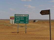
Oodnadatta can be reached by an unsealed road from Coober Pedy or via the unsealed Oodnadatta Track from Marree to Marla or from the north via Finke/Aputula, NT (on the "Old Ghan Heritage Trail").[21]
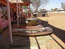
The Pink Roadhouse (so-called because it is painted bright pink) provides petrol, a general store, meals, a variety of accommodation, and post office facilities.[23] The Transcontinental Hotel, built in the 1890s, is on the same side of the road, as is the caravan park.[9][24]
Oodnadatta is serviced twice weekly by the Coober Pedy Oodnadatta One Day Mail Run. The OKA mail truck also carries some general freight and passengers.[25]
The air strip, originally built for use in World War II[26] is due for an upgrade in 2019 to repair and reseal the runway.[27]
Historic buildings
The historic Oodnadatta railway station, now a museum, is listed on the South Australian Heritage Register.[28]
Demographics
The population of Oodnadatta numbered 204 in 2016. Aboriginal and/or Torres Strait Islander people made up 53.3% of the population.[2] This represented a decrease since 2006, when there were 277 people, of whom less than half were Indigenous.[29]
In 2016, 61.7% of people spoke only English at home. Other languages spoken included Yankunytjatjara 4.7%, Luritja 3.6%, Afrikaans 1.6%, Tagalog 1.6% and Pitjantjatjara 1.6%.[2]
Oodnadatta Aboriginal School
The Oodnadatta Aboriginal School, located in Kutaya Terrace, is a school operated by the Government of South Australia offering education from Reception to Year 12. In 2018, the school had a total enrolment of 14 students, of whom 86% were indigenous, and a teaching staff of three.[30][31]
Climate
Oodnadatta has a hot desert climate (Köppen climate classification BWh)[32] and has also recorded the highest reliably measured maximum temperature in Australia: 50.7 °C (123.3 F) on 2 January 1960. A higher temperature was recorded at Cloncurry in 1889; however, this has since been shown to have been recorded in a non-standard enclosure and likely to have been considerably cooler than first believed.[33] There is a large sign in Oodnadatta claiming the town is "The driest town, the driest state of the driest Continent".[34]
| Climate data for Oodnadatta Airport (1939–2016) | |||||||||||||
|---|---|---|---|---|---|---|---|---|---|---|---|---|---|
| Month | Jan | Feb | Mar | Apr | May | Jun | Jul | Aug | Sep | Oct | Nov | Dec | Year |
| Record high °C (°F) | 50.7 (123.3) |
46.8 (116.2) |
44.9 (112.8) |
42.1 (107.8) |
35.0 (95.0) |
32.8 (91.0) |
32.2 (90.0) |
36.5 (97.7) |
40.7 (105.3) |
45.4 (113.7) |
47.3 (117.1) |
48.4 (119.1) |
50.7 (123.3) |
| Average high °C (°F) | 37.8 (100.0) |
36.6 (97.9) |
33.7 (92.7) |
28.5 (83.3) |
23.2 (73.8) |
19.9 (67.8) |
19.6 (67.3) |
22.1 (71.8) |
26.6 (79.9) |
30.2 (86.4) |
33.7 (92.7) |
36.3 (97.3) |
29.0 (84.2) |
| Daily mean °C (°F) | 30.4 (86.7) |
29.5 (85.1) |
26.5 (79.7) |
21.5 (70.7) |
16.5 (61.7) |
13.2 (55.8) |
12.7 (54.9) |
14.8 (58.6) |
19.0 (66.2) |
22.7 (72.9) |
26.1 (79.0) |
29.3 (84.7) |
21.8 (71.2) |
| Average low °C (°F) | 23.0 (73.4) |
22.3 (72.1) |
19.2 (66.6) |
14.4 (57.9) |
9.7 (49.5) |
6.5 (43.7) |
5.8 (42.4) |
7.4 (45.3) |
11.4 (52.5) |
15.1 (59.2) |
18.5 (65.3) |
21.2 (70.2) |
14.5 (58.1) |
| Record low °C (°F) | 11.7 (53.1) |
12.8 (55.0) |
9.5 (49.1) |
3.8 (38.8) |
0.9 (33.6) |
−2.6 (27.3) |
−2.2 (28.0) |
−0.3 (31.5) |
2.2 (36.0) |
5.1 (41.2) |
9.6 (49.3) |
11.3 (52.3) |
−2.6 (27.3) |
| Average precipitation mm (inches) | 22.9 (0.90) |
32.2 (1.27) |
14.1 (0.56) |
11.1 (0.44) |
12.8 (0.50) |
11.8 (0.46) |
10.0 (0.39) |
8.1 (0.32) |
9.9 (0.39) |
13.9 (0.55) |
13.0 (0.51) |
17.1 (0.67) |
177.1 (6.97) |
| Average precipitation days (≥ 0.2 mm) | 2.9 | 2.8 | 2.3 | 2.3 | 2.7 | 3.0 | 2.5 | 2.4 | 2.7 | 3.6 | 3.6 | 3.5 | 34.3 |
| Mean monthly sunshine hours | 337.9 | 315.0 | 313.1 | 273.0 | 244.9 | 231.0 | 254.2 | 275.9 | 291.0 | 316.2 | 321.0 | 341.0 | 3,514.2 |
| Source: Bureau of Meteorology[8] | |||||||||||||
| Climate data for Oodnadatta Airport (1981–2010) | |||||||||||||
|---|---|---|---|---|---|---|---|---|---|---|---|---|---|
| Month | Jan | Feb | Mar | Apr | May | Jun | Jul | Aug | Sep | Oct | Nov | Dec | Year |
| Record high °C (°F) | 50.7 (123.3) |
46.8 (116.2) |
44.9 (112.8) |
42.1 (107.8) |
35.0 (95.0) |
32.8 (91.0) |
32.2 (90.0) |
36.5 (97.7) |
40.7 (105.3) |
45.4 (113.7) |
47.3 (117.1) |
48.3 (118.9) |
50.7 (123.3) |
| Average high °C (°F) | 38.4 (101.1) |
37.1 (98.8) |
33.8 (92.8) |
29.0 (84.2) |
23.7 (74.7) |
20.0 (68.0) |
19.8 (67.6) |
22.9 (73.2) |
27.6 (81.7) |
30.5 (86.9) |
34.1 (93.4) |
36.4 (97.5) |
29.4 (84.9) |
| Daily mean °C (°F) | 31.1 (88.0) |
30.0 (86.0) |
26.6 (79.9) |
21.8 (71.2) |
16.9 (62.4) |
13.2 (55.8) |
12.9 (55.2) |
15.5 (59.9) |
20.0 (68.0) |
22.9 (73.2) |
26.7 (80.1) |
29.1 (84.4) |
22.2 (72.0) |
| Average low °C (°F) | 23.7 (74.7) |
22.9 (73.2) |
19.3 (66.7) |
14.9 (58.8) |
10.0 (50.0) |
6.3 (43.3) |
6.0 (42.8) |
8.0 (46.4) |
12.4 (54.3) |
15.3 (59.5) |
19.3 (66.7) |
21.8 (71.2) |
15.0 (59.0) |
| Record low °C (°F) | 11.7 (53.1) |
12.8 (55.0) |
9.5 (49.1) |
3.8 (38.8) |
0.9 (33.6) |
−2.6 (27.3) |
−2.2 (28.0) |
−0.3 (31.5) |
2.2 (36.0) |
5.1 (41.2) |
9.6 (49.3) |
11.3 (52.3) |
−2.6 (27.3) |
| Average precipitation mm (inches) | 29.2 (1.15) |
32.8 (1.29) |
10.4 (0.41) |
10.0 (0.39) |
7.1 (0.28) |
9.8 (0.39) |
9.4 (0.37) |
5.5 (0.22) |
9.9 (0.39) |
15.4 (0.61) |
17.8 (0.70) |
27.2 (1.07) |
185.2 (7.29) |
| Average precipitation days (≥ 0.2 mm) | 2.8 | 3.2 | 2.4 | 2.1 | 2.4 | 2.9 | 2.8 | 1.8 | 3.1 | 4.1 | 4.1 | 4.7 | 36.3 |
| Mean monthly sunshine hours | 337.9 | 315.0 | 313.1 | 273.0 | 244.9 | 231.0 | 254.2 | 275.9 | 291.0 | 316.2 | 321.0 | 341.0 | 3,514.2 |
| Source: Bureau of Meteorology[8] | |||||||||||||
References
Notes
- For the 2016 census, the State Suburb of Oodnadatta covered an area bounded by the Anangu Pitjantjatjara Yankunytjatjara lands in the west, the Northern Territory border in the north, the Munga-Thirri—Simpson Desert Conservation Park in the east and with its southern boundary aligning approximately with the northern end of Lake Eyre. The state suburb did not include the locality of Marla which it fully surrounded.[2][1]
Citations
- "Search results for 'Oodnadatta, LOCB' with the following datasets: 'Suburbs and Localities', 'Counties', 'Government Towns', 'Local Government Areas', 'SA Government Regions' and 'Gazetteer'". Location SA Map Viewer. Government of South Australian Government. Retrieved 13 May 2018.
- Australian Bureau of Statistics (27 June 2017). "Oodnadatta". 2016 Census QuickStats. Retrieved 29 May 2019.

- Bray, J.C. (30 October 1890). "Untitled proclamation (Town of Oodnadatta)" (PDF). The South Australian Government Gazette. South Australian Government. p. 1068. Retrieved 13 May 2018.
- "Postcode for Oodnadatta, South Australia". Postcodes Australia. Retrieved 13 May 2018.
- "Search results for 'Oodnadatta Railway Station' with the following datasets selected – 'Suburbs and Localities', 'Government Towns' and 'Gazetteer'". Location SA Map Viewer. Government of South Australian Government. Retrieved 13 May 2018.
- "District of Giles Background Profile". Electoral Commission SA. Retrieved 12 February 2018.
- "Federal electoral division of Grey" (PDF). Australian Electoral Commission. Retrieved 12 February 2018.
- "Climate Statistics for Oodnadatta Airport". Climate statistics for Australian locations. Bureau of Meteorology. Retrieved 31 March 2013.
- "Oodnadatta". Sydney Morning Herald. 8 February 2004. Retrieved 29 May 2019.
- "Alfred Giles – Enjoying Life at 80". The Mail. Adelaide: National Library of Australia. 22 September 1928. p. 3. Retrieved 30 January 2013.
- http://www.exploroz.com/Places/77748/SA/The_Angle_Pole_Memorial.aspx
- "RAILWAY CONSTRUCTION IN WESTERN AUSTRALIA". The Sydney Morning Herald. National Library of Australia. 14 February 1889. p. 7. Retrieved 28 December 2012.
- "Search result for "Angle Pole" (Record No. SA0001492)". Department of Planning Transport and infrastructure. 1 July 2004. Archived from the original on 12 October 2016. Retrieved 29 October 2015.
- "Freeling Springs (The Peake)". Friends of Mound Springs. Retrieved 28 May 2019.
- "The Afghan Camelmen". South Australian History. Retrieved 29 May 2019.
- "Pioneer Memorial". Monuments Australia. Retrieved 29 May 2019.
- "Public works and railways". South Australian Chronicle. XXXII (1, 637). South Australia. 4 January 1890. p. 9. Retrieved 22 March 2017 – via National Library of Australia.
- Great Northern to Government Gums – A Mineral Railway Callaghan, W.H. Australian Railway History, September;October, 2008 pp283-301;323-336
- "Another railway syndicate". South Australian Register. Adelaide: National Library of Australia. 14 February 1889. p. 6. Retrieved 29 May 2019.
- Tregaskis, Moana (16 September 1990). "On the 2 pm from Adelaide to Alice". The New York Times. Retrieved 27 January 2008.
- "Outback: The Oodnadatta Track". National Roads and Motorists' Association (NRMA). Archived from the original on 6 August 2008. Retrieved 24 June 2008.
- "Upgrades for critical road links in outback South Australia". Australian Government. Dept of Infrastructure. Retrieved 29 May 2019.
- "Are you up for it?". The Pink Roadhouse. Retrieved 29 May 2019.
- "Oodnadatta". South Australian History. Retrieved 29 April 2019.
- "Coober Pedy Oodnadatta One Day Mail Run". Archived from the original on 3 May 2006.
- "Military airfields in Australia and the Western Pacific area during World War 2". Oz at war. Retrieved 29 May 2019.
- "Remote Airstrip Upgrade Programme Round 6 — Approved Projects". Australian Government. DITCRD. Retrieved 19 May 2019.
- "Museum (former Oodnadatta Railway Complex, including Station/Residence, Goods Shed and Crane)". South Australian Heritage Register. Department of Environment, Water and Natural Resources. Retrieved 12 February 2016.
- Australian Bureau of Statistics (25 October 2007). "Oodnadatta (State Suburb)". 2006 Census QuickStats. Retrieved 28 February 2008.
- "Oodnadatta Aboriginal School, Oodnadatta, SA", My School, Australian Curriculum, Assessment and Reporting Authority (ACARA), retrieved 11 August 2019
- "Contact", Oodnadatta Aboriginal School, Government of South Australia, retrieved 11 August 2019
- Peel, M. C. and Finlayson, B. L. and McMahon, T. A. (2007). "Updated world map of the Köppen–Geiger climate classification" (PDF). Hydrol. Earth Syst. Sci. 11 (5): 1636 & 1642. doi:10.5194/hess-11-1633-2007. ISSN 1027-5606.CS1 maint: multiple names: authors list (link)
- "Queensland to bake on Christmas Day". AM. Australian Broadcasting Corporation. 24 December 2003. Retrieved 17 November 2009.
- "Too Hot to Refuel as Town Bakes". Adelaide Now. 9 January 2013. Retrieved 9 January 2013.
- Categories for Naming Features on Planets and Satellites, Gazetteer of Planetary Nomenclature, USGS Astrogeology Science Center, NASA
Further reading
- Oodnadatta (on Flinders Ranges Research)
- Oodnadatta (Aussie Towns)
- Tracking History to Oodnadatta by Roderick Eime
- Oodnadatta Pioneer Cemetery with photos of headstones
External links
| Wikivoyage has a travel guide for Oodnadatta. |
| Authority control |
|
|---|