Nikanassin Range
The Nikanassin Range is a group of mountain ranges in the Canadian Rockies on the eastern edge of Jasper National Park in Alberta, Canada. It is developed south-east of the Fiddle Range, and one of the front ranges. Nikanassin means "first range" in Cree.
| Nikanassin Range | |
|---|---|
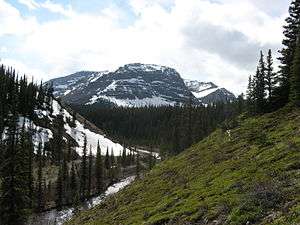 Cardinal River flowing east through the Nikanassin Range | |
| Highest point | |
| Peak | Climax Mountain |
| Elevation | 2,823 m (9,262 ft) |
| Coordinates | 52°54′N 117°25′W |
| Dimensions | |
| Length | 80 km (50 mi) W-E |
| Width | 66 km (41 mi) N-S |
| Area | 2,760 km2 (1,070 sq mi) |
| Geography | |
| Country | Canada |
| Province | Alberta |
| Range coordinates | 52°57′N 117°9′W |
| Parent range | Canadian Rockies |
The range has an extent of 2,760 square kilometres (1,070 sq mi),[1] with a length of 80 kilometres (50 mi) from north-west to south-east, and a width of 66 kilometres (41 mi). Its highest point is Climax Mountain, with a height of 2,823 metres (9,262 ft).
Numerous seams of coal are found in this range, with past and present mines at Cadomin, Mountain Park and Luscar.[2]
The range gives the name to the Nikanassin Formation, a stratigraphical unit of late Jurassic age that has its stratotype in this region.
Peaks
| Mountain | metres | feet |
|---|---|---|
| Climax Mountain | 2823 | 9262 |
| Deception Mountain | 2819 | 9249 |
| Mount Lindsay | 2743 | 8999 |
| Mount Bryant | 2621 | 8599 |
| Overturn Mountain | 2560 | 8399 |
References
- Peakbagger. "Nikanassin Range". Retrieved 2009-02-05.
- Bivuac.com. "Nikanassin Range". Retrieved 2009-02-05.