Nain, Newfoundland and Labrador
Nain or Naina (Inuit: Nunainguk) is the northernmost permanent settlement in the Canadian province of Newfoundland and Labrador, within the Nunatsiavut region of Inuit Nunangat, located about 370 kilometres (230 mi) by air from Happy Valley-Goose Bay. The town was established as a Moravian mission in 1771 by Jens Haven and other missionaries. As of 2011, the population is 1,424 mostly Inuit and mixed Inuit-European.
Nain Nunainguk[1] | |
|---|---|
Inuit community | |
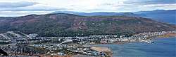 Nain as viewed from Mt. Sophie, September 2011. | |
 Nain Location of Nain in the province | |
| Coordinates: 56°32′32″N 61°41′34″W | |
| Country | Canada |
| Province | Newfoundland and Labrador |
| Inuit homeland | Inuit Nunangat |
| Region | Nunatsiavut |
| Settled | 1771 |
| Government | |
| • Type | Inuit Community Government |
| • Mayor (AngajukKâk) | Joe Dicker |
| • Federal MP | Yvonne Jones (L) |
| • Provincial MHA | Lela Evans (PC) |
| • Nunatsiavut Assembly members | Tony Andersen Jim Lyall |
| Area | |
| • Total | 94.58 km2 (36.52 sq mi) |
| Elevation | 11 m (36 ft) |
| Population (2016)[2] | |
| • Total | 1,125 |
| • Density | 11.9/km2 (31/sq mi) |
| Time zone | UTC-4 (AST) |
| • Summer (DST) | UTC-3 (Atlantic Daylight Saving Time) |
| Postal code span | A0P |
| Area code(s) | 709 |
History
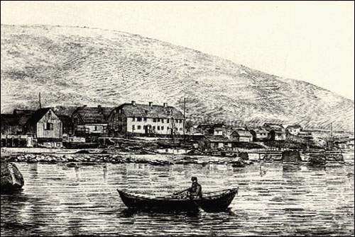
_(14781543365).jpg)
Nain was first established in 1771 by Moravian missionaries. It is among the oldest permanent Inuit settlements in Canada, most communities in Nunavut and Nunavik were settled in the 1950s or later. It is also the oldest continuously-inhabited community in Labrador after North West River. Nain has also been called "Nonynuke", "Nuninock" and "Nunaingoakh".[3] The missionaries also established posts in Hopedale and areas in the north such as Hebron and Okak. The first Inuk to be baptized in Nain was a man named Kingminguse who took the name "Petrus" after conversion and then returned to southern Labrador where he used the name "Petrus Kingminguse" and died in 1800.[4] Many Inuit in the south traveled to the Moravian posts in the north to be baptized and then returned to the south. The Moravians established posts only in northern areas since the Colony of Newfoundland hoped to colonize southern Labrador. In 1773, it was claimed that over 250 Inuit lived in Nain.[3] In 1893, Nain's residents adopted patrilineal surnames at the request of Newfoundland courts. Many people took names of the missionaries (such as "Kohlmeister" and Townley") while others chose traditional names such as "Aggek", "Karpik", "Mitsuk" and "Nochasak".
In 1959, residents of Hebron and Nutak resettled to Nain, Hopedale, Makkovik and Happy Valley-Goose Bay. The relocation had a huge impact on residents of Hebron and Nutak since the land in Nain (and other communities) was very different (resulting in difficulties when hunting) and many families were divided. Poverty and alcoholism has affected many of the families that originated in Hebron and Nutak. The provincial government apologized for the relocations in 2005. Many Inuit from Hebron were relocated to Nain by the provincial government after the Moravian mission at Hebron was closed under government pressure in 1959.
In 2016, the Google Street View imaging service uploaded images of various roads in Nain. Nain is one of the few communities in Labrador with images on the service.
Nunatsiavut
On December 1, 2005, Nain became the administrative capital of the autonomous region of Nunatsiavut which is the name chosen by the Labrador Inuit when the Labrador Inuit Land Claims Agreement Act was successfully ratified by the Canadian Government and the Inuit of Labrador. Hopedale, further south, is the legislative capital.[5] The land claim cedes limited self-rule for the Nunatsiavut government in Northern Labrador and North-Eastern Quebec, granting title and aboriginal rights.[5] The land that comprises the Nunatsiavut government is called the Labrador Inuit Settlement Area, or LISA, which amount to approximately 72,500 km2 (28,000 sq mi).[6] The Inuit of Labrador do not own this land per se, but they do have special rights related to traditional land use as aboriginals. That said, the Labrador Inuit will own 15,000 km2 (5,800 sq mi) within the Settlement Area, officially designated as Labrador Inuit Lands. The Agreement also provides for the establishment of the Torngat Mountains National Park Reserve, consisting of about 9,600 square kilometres (3,700 sq mi) of land within LISA.[6][7] Nunatsiavut is not to be confused with the Nunavut territory.
Geography
Nain is located on the north side of Unity Bay, a small inlet. The bay is open to the Atlantic Ocean but Nain's harbour is protected by numerous islands, the largest of which is Paul's Island. From Nain to the open Labrador Sea is approximately 50 km (31 mi) east through Strathcona Run. Nain is inaccessible by road and may be reached only by air or sea.
Climate
Although located at the same latitude as Ketchikan on North America's west coast or Moscow, Scotland and southern Scandinavia in Europe, the influence of the Labrador Current gives Nain a marginal subarctic climate (Dfc) that is very close to a polar climate (ET), which creates the southernmost tree line in the northern hemisphere on the adjacent coast. The southernmost tundra is actually still in a zone of discontinuous permafrost rather than the much more typical continuous zone.[8] The almost constant presence of the Icelandic Low means that precipitation, both as rain and snow, is exceptionally heavy for so consistently cold a climate in a low-lying area, with 5 metres (16 ft) of snow falling each winter. The actual depth of snow on the ground averages 1.13 metres (44 in) at the end of March.
| Climate data for Nain (1981–2010 normals) | |||||||||||||
|---|---|---|---|---|---|---|---|---|---|---|---|---|---|
| Month | Jan | Feb | Mar | Apr | May | Jun | Jul | Aug | Sep | Oct | Nov | Dec | Year |
| Record high humidex | 9.0 | 6.5 | 9.0 | 12.8 | 24.8 | 38.1 | 40.2 | 41.4 | 30.5 | 16.9 | 10.6 | 4.8 | 41.4 |
| Record high °C (°F) | 15.7 (60.3) |
7.6 (45.7) |
12.1 (53.8) |
14.5 (58.1) |
25.6 (78.1) |
33.3 (91.9) |
33.3 (91.9) |
32.7 (90.9) |
26.1 (79.0) |
19.4 (66.9) |
11.7 (53.1) |
6.7 (44.1) |
33.3 (91.9) |
| Average high °C (°F) | −13.5 (7.7) |
−13.0 (8.6) |
−7.5 (18.5) |
0.0 (32.0) |
5.6 (42.1) |
11.0 (51.8) |
14.9 (58.8) |
15.8 (60.4) |
11.5 (52.7) |
5.1 (41.2) |
−1.3 (29.7) |
−8.1 (17.4) |
1.7 (35.1) |
| Daily mean °C (°F) | −17.6 (0.3) |
−17.4 (0.7) |
−12.5 (9.5) |
−4.6 (23.7) |
1.5 (34.7) |
6.4 (43.5) |
10.1 (50.2) |
11.0 (51.8) |
7.5 (45.5) |
2.1 (35.8) |
−4.4 (24.1) |
−11.8 (10.8) |
−2.5 (27.6) |
| Average low °C (°F) | −21.6 (−6.9) |
−21.8 (−7.2) |
−17.4 (0.7) |
−9.1 (15.6) |
−2.5 (27.5) |
1.8 (35.2) |
5.3 (41.5) |
6.1 (43.0) |
3.4 (38.1) |
−1.0 (30.2) |
−7.5 (18.5) |
−15.4 (4.3) |
−6.6 (20.0) |
| Record low °C (°F) | −39.4 (−38.9) |
−38.3 (−36.9) |
−37.0 (−34.6) |
−31.1 (−24.0) |
−17.5 (0.5) |
−6.7 (19.9) |
−2.8 (27.0) |
−2.8 (27.0) |
−6.7 (19.9) |
−19.0 (−2.2) |
−24.4 (−11.9) |
−41.5 (−42.7) |
−41.5 (−42.7) |
| Record low wind chill | −52.9 | −59.5 | −54 | −41.3 | −20.8 | −10.1 | −5 | −3.4 | −9.1 | −31.2 | −33.3 | −55.5 | −59.5 |
| Average precipitation mm (inches) | 83.8 (3.30) |
70.9 (2.79) |
73.6 (2.90) |
71.1 (2.80) |
57.0 (2.24) |
83.4 (3.28) |
98.6 (3.88) |
71.5 (2.81) |
81.9 (3.22) |
74.2 (2.92) |
77.6 (3.06) |
81.9 (3.22) |
925.5 (36.42) |
| Average rainfall mm (inches) | 3.1 (0.12) |
5.1 (0.20) |
5.5 (0.22) |
14.1 (0.56) |
30.2 (1.19) |
70.1 (2.76) |
98.6 (3.88) |
71.5 (2.81) |
79.9 (3.15) |
49.7 (1.96) |
14.1 (0.56) |
8.4 (0.33) |
450.3 (17.74) |
| Average snowfall cm (inches) | 80.9 (31.9) |
65.9 (25.9) |
68.2 (26.9) |
56.9 (22.4) |
26.7 (10.5) |
13.3 (5.2) |
0.0 (0.0) |
0.0 (0.0) |
2.0 (0.8) |
24.5 (9.6) |
63.5 (25.0) |
73.4 (28.9) |
475.3 (187.1) |
| Average precipitation days (≥ 0.2 mm) | 14.1 | 12.0 | 13.1 | 13.7 | 13.0 | 15.0 | 16.0 | 15.4 | 15.3 | 14.6 | 13.8 | 14.1 | 170.1 |
| Average rainy days (≥ 0.2 mm) | 1.0 | 1.0 | 1.6 | 3.4 | 8.3 | 14.2 | 16.2 | 15.4 | 15.2 | 10.1 | 3.1 | 1.8 | 91.3 |
| Average snowy days (≥ 0.2 cm) | 13.9 | 11.7 | 12.8 | 12.2 | 7.7 | 2.9 | 0.0 | 0.0 | 0.8 | 7.4 | 12.6 | 13.3 | 95.3 |
| Source: Environment Canada[9] | |||||||||||||
_Labrador.jpg)
Local government
The town is governed by a seven-member council composed of a mayor (or Angajukĸâk), deputy mayor (Deputy Angajukĸâk), and five councilors. In 2004 Sarah Leo was the mayor with George Lyall as deputy mayor, while the remaining councilors were Mary White, Isabella Pain, Margaret Fox, Duane Dicker, and Jacob Larkin.[10]
The Town Council formally changed its name from "Nain Town Council" to "Nain Inuit Community Government" in October 2006. The Nain Inuit Community Government meets once per month.
Educational facilities
Nain has one kindergarten to level III school, Jens Haven Memorial, which is split between two buildings. One building contains primary grades (kindergarten to grade 3), the other houses elementary and secondary grades (grade 4 to Level III).
There is also an adult basic education (ABE) program offered in town, delivered by Academy Canada. Academy Canada delivers this program in Nain and throughout Labrador in communities including Happy Valley - Goose Bay, Hopedale, Labrador City, Natuashish and Sheshatshiu.
Industry
Fishing is the main industry in Nain. Traditional hunting and trapping activities continue through the winter months after the fishing season has ended.
Demographics
Ethnicity
| Canada 2016 Census | Population | % of Total Population | |
|---|---|---|---|
| Visible minority group Source:[11] | South Asian | 0 | 0.0 |
| Chinese | 0 | 0.0 | |
| Black | 0 | 0.0 | |
| Filipino | 0 | 0 .0 | |
| Latin American | 0 | 0.0 | |
| Southeast Asian | 0 | 0.0 | |
| Other visible minority | 0 | 0.0 | |
| Total visible minority population | 0 | 0.0 | |
| Aboriginal group Source:[11] | First Nations | 25 | 2.2 |
| Métis | 15 | 1.3 | |
| Inuit | 1,025 | 91.1 | |
| Total Aboriginal population | 1,035 | 92.0 | |
| White | 90 | 8.0 | |
| Total population | 1,125 | 100.0 | |
Language (2016 census)
- English: 810
- Inuktitut: 295
Media
Nain has two radio services available.
CKOK-FM is a low-power (LP) re-broadcaster of CKHV broadcasting at 99.9 FM. Owned by the Okalakatiget Society, the station broadcasts a community radio format for the region's First Nations and Inuit communities.
As of the end of 2014, the station now streams online. It broadcasts live during local programming only.
There is also a local re-broadcaster of Happy Valley-Goose Bay's CBC Radio One feed, CBNZ. It operates on 740 AM.
Transport
Flights to Nain are at Nain Airport, and are available from Happy Valley-Goose Bay on Air Borealis (part of PAL Airlines).
Between mid-June and mid-November (pending ice conditions), the ferry MV Northern Ranger, operated by the Newfoundland and Labrador Government, provides weekly service[12] from Goose Bay along the Atlantic Coast, with stops in Rigolet, Makkovik, Postville, Hopedale and Natuashish. Nain is the northernmost stop on the route; the ferry stays docked at Nain for about three hours before beginning its southbound route.[12]
See also
- List of cities and towns in Newfoundland and Labrador
References
- https://inuktutlexicon.gcrc.carleton.ca/index.html?module=module.inuktutlexicon_word_list#eyJ0IjoieCIsImkiOiIyZjUyOGFkZjY0MzNiMGIxZjJmNzE1NThiYjAzZmYxMSIsInMiOjE1ODEyOTE2MDA1NDd9
- "Nain, Town [Census subdivision], Newfoundland and Labrador and Division No. 11, Census division [Census division], Newfoundland and Labrador". Statistics Canada. Government of Canada. Retrieved May 19, 2018.
- "Toponymic and Cartographic Research Conducted for the Labrador Métis Nation" (PDF). mun.ca. September 2008. Archived from the original (PDF) on 2018-01-04. Retrieved 26 December 2018.
- Rollman, Hans (18 June 2011). "'For them, it's all about the name'". The Telegram. Archived from the original on 2 October 2012. Retrieved 26 December 2018.
- "Nunatsiavut Government". nunatsiavut.com. Archived from the original on 2010-02-28. Retrieved 26 December 2018.
- "Archived copy". Archived from the original on 2008-06-09. Retrieved 2008-09-23.CS1 maint: archived copy as title (link)
- "Archived copy". Archived from the original on 2007-10-22. Retrieved 2008-09-23.CS1 maint: archived copy as title (link)
- "The Atlas of Canada - Permafrost". Archived from the original on 2012-10-06. Retrieved 2011-09-04.
- "Canadian Climate Normals 1981-2010: Nain A". Environment Canada. Retrieved 2 March 2019.
- "Archived copy". Archived from the original on 2007-08-20. Retrieved 2008-09-23.CS1 maint: archived copy as title (link)
- "Goose Bay - Rigolet - Cartwright - Black Tickle - Ports North To Nain". Provincial Ferry Services. Archived from the original on 2009-08-11. Retrieved 2009-08-30.
External links
- Nineteenth-Century artwork of Nain
- Okalakatiget Society
- Okalakatiget Society Live Web Stream [Local Programming Only]
- Query the REC Canadian station database for CKHV
- Query the REC Canadian station database for CKOK
- Nain - Encyclopedia of Newfoundland and Labrador, vol. 4, p. 1-3.
| Census divisions | |
|---|---|
| Cities | |
| Other communities |
|
| |