Makkovik
Makkovik (Inuit: Maggovik) is a town in Labrador in eastern Canada. It had a population of 361 persons in 2011. The main industry is fishing (snow crab) and there is a fishing cooperative.
Makkovik Maggovik[1] | |
|---|---|
Town | |
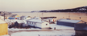 View of Makkovik. | |
 Makkovik Location of Makkovik in Labrador  Makkovik Makkovik (Canada) | |
| Coordinates: 55°04′38″N 59°11′16″W | |
| Country | Canada |
| Province | Newfoundland and Labrador |
| Region | Nunatsiavut |
| Settled | 1860 |
| Incorporated | March 26, 1970 |
| Government | |
| • Mayor (AngajukKâk) | Herbert Jacque |
| • Federal MP | Yvonne Jones (L) |
| • Provincial MHA | Lela Evans (PC) |
| • Nunatsiavut Assembly member | Kate Mitchell (I) |
| Area | |
| • Land | 1.97 km2 (0.76 sq mi) |
| Population (2011) | |
| • Total | 361 |
| • Density | 182.9/km2 (474/sq mi) |
| Time zone | UTC−04:00 (AST) |
| • Summer (DST) | UTC−03:00 (ADT) |
| Canadian Postal code | A0P 1J0 |
| Area code(s) | 709 |
History
Settled by Torsten Kverna Andersen and his wife Mary Ann Thomas who set up a trading post there in 1860, the population gradually increased over the next three decades as European settlers and Inuit established roots in the community, though this territory since time immemorial was used by Inuit. Other European settlers came mainly from Scotland (bringing surnames like Lyall and McNeill) and Quebec (bringing names like Perrault and Jacque). Colonization was assured in 1896 when the Moravian Church established a mission station and residential school there. Both the mission and school were destroyed by a fire in 1948 but the economy was instilled in the 1950s by two notable events. First was the forceful resettlement to Makkovik of 150 Inuit residents of the northern communities of Nutak and Hebron. Second was the establishment nearby of a radar warning station by the United States government.
The population is mainly composed of residents of mixed European and Inuit heritage. 95 people in Makkovik claimed to have Norwegian ancestry in the 2016 census[2].
Geography
The community lies at the end of a peninsula in northern Labrador about 215 km (134 mi) northeast of Happy Valley-Goose Bay. Travel is by air year round (served by Makkovik Airport) and by boat in summer. Winter travel is by snowmobile. The community is situated on a sheltered bay in a saddle between two hills. In the lee of the northernmost hill is a large copse of tall spruce trees, which is remarkable given the paucity of tree cover for miles around. Now known as the Moravian Wood, there is a small cemetery in the centre.
Geology
The community is located in the Makkovik Province, a Paleoproterozoic accretionary belt which is the smallest defined tectonic component of the Canadian Shield. The Makkovik Province is separated from the Nain Province to the north by the Kanairiktok Shear Zone and from the Grenville Province to the south by the Grenville Front, which marks the northern limit of the widespread Grenvillian deformation. Prior to the opening of the Labrador Sea the Makkovik Province lay adjacent to the Ketilidian Mobile Belt which currently forms part of Southwest Greenland.
Climate
Like most of Labrador, Makkovik has a subarctic climate (Köppen Dfc) with short, mild summers and very cold winters; however, typically for its region but unusually for subarctic regions generally, precipitation is high with a minimum in the "spring" months from March to May. This high precipitation and cool summers is due to the powerful influence of the Icelandic Low and the Labrador Current on its western side, and gives very heavy snowfall of 411.6 cm (162.0 in) per year with an average maximum cover of 69 cm (27 in) during March and April. The greatest snow depth was 152 cm (60 in) on April 17, 1997. Unlike most places with a pronounced subarctic climate, Makkovik has a pronounced seasonal lag with August being much warmer than July and September averaging slightly warmer than June.
| Climate data for Makkovik, Newfoundland and Labrador (1981-2010) | |||||||||||||
|---|---|---|---|---|---|---|---|---|---|---|---|---|---|
| Month | Jan | Feb | Mar | Apr | May | Jun | Jul | Aug | Sep | Oct | Nov | Dec | Year |
| Record high humidex | 10.8 | 8.3 | 12.8 | 15.5 | 27.0 | 36.6 | 42.6 | 42.5 | 31.4 | 20.6 | 16.9 | 8.5 | 42.6 |
| Record high °C (°F) | 12.0 (53.6) |
10.0 (50.0) |
13.0 (55.4) |
14.0 (57.2) |
28.0 (82.4) |
34.5 (94.1) |
33.5 (92.3) |
34.5 (94.1) |
29.0 (84.2) |
18.5 (65.3) |
16.0 (60.8) |
14.0 (57.2) |
34.5 (94.1) |
| Average high °C (°F) | −12.6 (9.3) |
−12.1 (10.2) |
−6.2 (20.8) |
0.5 (32.9) |
6.8 (44.2) |
12.5 (54.5) |
16.5 (61.7) |
17.2 (63.0) |
12.4 (54.3) |
5.7 (42.3) |
−1.1 (30.0) |
−7.5 (18.5) |
2.7 (36.8) |
| Daily mean °C (°F) | −16.7 (1.9) |
−16.5 (2.3) |
−10.6 (12.9) |
−3.1 (26.4) |
2.8 (37.0) |
7.8 (46.0) |
11.6 (52.9) |
12.6 (54.7) |
8.6 (47.5) |
2.8 (37.0) |
−3.9 (25.0) |
−11.0 (12.2) |
−1.3 (29.7) |
| Average low °C (°F) | −20.8 (−5.4) |
−20.7 (−5.3) |
−15.0 (5.0) |
−6.8 (19.8) |
−1.2 (29.8) |
3.1 (37.6) |
6.7 (44.1) |
7.9 (46.2) |
4.7 (40.5) |
−0.1 (31.8) |
−6.7 (19.9) |
−14.5 (5.9) |
−5.3 (22.5) |
| Record low °C (°F) | −37.0 (−34.6) |
−37.0 (−34.6) |
−32.5 (−26.5) |
−25.0 (−13.0) |
−14.0 (6.8) |
−3.5 (25.7) |
−1.0 (30.2) |
0.0 (32.0) |
−3.5 (25.7) |
−15.5 (4.1) |
−22.0 (−7.6) |
−33.5 (−28.3) |
−37.0 (−34.6) |
| Record low wind chill | −53 | −58 | −51 | −39 | −23 | −12 | −4 | 0 | −7 | −27 | −35 | −53 | −58 |
| Average precipitation mm (inches) | 72.6 (2.86) |
75.1 (2.96) |
72.9 (2.87) |
61.8 (2.43) |
52.0 (2.05) |
94.0 (3.70) |
101.0 (3.98) |
97.6 (3.84) |
91.9 (3.62) |
91.6 (3.61) |
84.1 (3.31) |
83.9 (3.30) |
978.5 (38.53) |
| Average rainfall mm (inches) | 2.5 (0.10) |
1.5 (0.06) |
7.2 (0.28) |
15.4 (0.61) |
33.1 (1.30) |
84.3 (3.32) |
101.1 (3.98) |
97.6 (3.84) |
90.5 (3.56) |
72.7 (2.86) |
22.2 (0.87) |
10.9 (0.43) |
539 (21.21) |
| Average snowfall cm (inches) | 67.5 (26.6) |
73.6 (29.0) |
64.0 (25.2) |
41.8 (16.5) |
16.5 (6.5) |
8.7 (3.4) |
0.1 (0.0) |
0.0 (0.0) |
1.3 (0.5) |
16.4 (6.5) |
54.8 (21.6) |
66.9 (26.3) |
411.6 (162.1) |
| Average precipitation days (≥ 0.2 mm) | 14.1 | 12.4 | 14.1 | 13.0 | 12.7 | 16.4 | 16.7 | 16.4 | 17.0 | 16.4 | 15.7 | 14.9 | 179.8 |
| Average rainy days (≥ 0.2 mm) | 0.81 | 0.48 | 2.3 | 4.4 | 9.2 | 15.6 | 16.7 | 16.4 | 16.8 | 13.1 | 5.0 | 2.3 | 103.09 |
| Average snowy days (≥ 0.2 cm) | 13.9 | 12.1 | 13.2 | 9.8 | 5.2 | 2.8 | 0.05 | 0.00 | 0.35 | 5.8 | 12.6 | 13.6 | 89.4 |
| Source: [3] | |||||||||||||
United States Air Force base
For three years in the late 1950s the United States Air Force operated a remote radar base approximately 15 kilometers north of the settlement. Called Cape Makkovik, it was constructed between 1955 and 1957 and operated until 1961, and dismantled later in the decade. It was a "gap-filler" in the Pinetree Line set up to monitor the skies for aircraft approaching from the north.
References
- https://inuktutlexicon.gcrc.carleton.ca/index.html?module=module.inuktutlexicon_word_list
- https://www12.statcan.gc.ca/census-recensement/2016/dp-pd/prof/details/page.cfm?Lang=E&Geo1=CSD&Code1=1011020&Geo2=PR&Code2=10&SearchText=Makkovik&SearchType=Begins&SearchPR=01&B1=All&GeoLevel=PR&GeoCode=1011020&TABID=1&type=0
- Climate Normals 1981-2010 Station Data
External links
| Census divisions | |
|---|---|
| Cities | |
| Other communities |
|
| |