Non Sang District
Non Sang District (Thai: โนนสัง; IPA: [nōːn sǎŋ]) is a district (amphoe) in the southeastern part of Nong Bua Lamphu Province, northeastern Thailand.
Non Sang โนนสัง | |
|---|---|
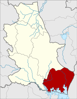 District location in Nong Bua Lamphu Province | |
| Coordinates: 16°51′56″N 102°34′20″E | |
| Country | Thailand |
| Province | Nong Bua Lamphu |
| Area | |
| • Total | 577.736 km2 (223.065 sq mi) |
| Population (2005) | |
| • Total | 64,172 |
| • Density | 111.1/km2 (288/sq mi) |
| Time zone | UTC+7 (ICT) |
| Postal code | 39140 |
| Geocode | 3903 |
Geography
Neighboring districts are (from the west clockwise) Si Bun Rueang and Mueang Nong Bua Lamphu of Nong Bua Lamphu Province, Nong Wua So of Udon Thani Province, Khao Suan Kwang, Ubolratana, Phu Wiang, and Nong Na Kham of Khon Kaen Province.
History
The area of the district was originally a tambon of Mueang Nong Bua Lam Phu District. On 1 January 1948 it was made a minor district (king amphoe),[1] which was upgraded to a full district on 9 June 1956.[2]
Administration
The district is divided into 10 sub-districts (tambons), which are further subdivided into 104 villages (mubans). There are two sub-district municipalities (thesaban tambons). Non Sang covers tambon Non Sang and Kut Du parts of tambon Kut Du. There are a further nine tambon administrative organizations (TAO).
| No. | Name | Thai | Villages | Pop.[3] |
|---|---|---|---|---|
| 1. | Non Sang | โนนสัง | 15 | 8,497 |
| 2. | Ban Thin | บ้านถิ่น | 9 | 6,337 |
| 3. | Nong Ruea | หนองเรือ | 12 | 9,430 |
| 4. | Kut Du | กุดดู่ | 14 | 9,774 |
| 5. | Ban Kho | บ้านค้อ | 10 | 5,080 |
| 6. | Non Mueang | โนนเมือง | 7 | 5,385 |
| 7. | Khok Yai | โคกใหญ่ | 7 | 3,726 |
| 8. | Khok Muang | โคกม่วง | 9 | 6,523 |
| 9. | Nikhom Phatthana | นิคมพัฒนา | 11 | 4,253 |
| 10. | Pang Ku | ปางกู่ | 10 | 5,289 |
References
- ประกาศกระทรวงมหาดไทย เรื่อง ยกฐานะตำบลขึ้นเป็นกิ่งอำเภอ (PDF). Royal Gazette (in Thai). 64 (60 ง): 3188–3193. 1947-12-09.
- พระราชกฤษฎีกาจัดตั้งอำเภอนาทวี อำเภอสะบ้าย้อย อำเภอคำชะอี อำเภอย่านตาขาว อำเภอวัดโบสถ์ อำเภอหนองบัว อำเภอวัฒนานคร อำเภอแสวงหา อำเภอท่าชนะ อำเภอพระพุทธบาท อำเภอโนนสัง อำเภอบำเหน็จณรงค์ อำเภอคอนสวรรค์ อำเภอบ้านโฮ่ง อำเภอคีรีมาศ อำเภอชนแดน อำเภอแม่แจ่ม อำเภอไทรน้อย และอำเภอบ้านแพง พ.ศ. ๒๔๙๙ (PDF). Royal Gazette (in Thai). 73 (46 ก): 657. 1956-06-05.
- "Population statistics 2008". Department of Provincial Administration.
External links
- amphoe.com (Thai)