Mount Royal, Quebec
Mount Royal (officially, Town of Mount Royal, abbreviated TMR) is an affluent on-island suburban town located on the northwest side of the eponymous Mount Royal, northwest of Downtown Montreal, on the Island of Montreal in southwestern Quebec, Canada. It is completely surrounded by Montreal. The population was 20,276[7] as of the Canada 2016 Census. In 2008, most of the Town of Mount Royal was designated a National Historic Site of Canada, as a "[remarkable] synthesis of urban renewal movements of the early 20th century, reflecting the influence of the City Beautiful, Garden City and Garden Suburb movements".[8] The town celebrated its 100th anniversary in 2012.
Mount Royal | |
|---|---|
| Town of Mount Royal Ville de Mont-Royal | |
 Connaught Park | |
| Motto(s): Regium Donum (Latin for "Royal gift") | |
 Location on the Island of Montreal. (Outlined areas indicate demerged municipalities). | |
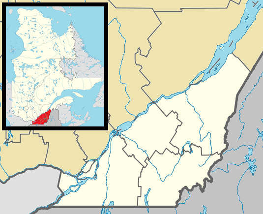 Mount Royal Location in southern Quebec | |
| Coordinates: 45°30′58″N 73°38′35″W[3] | |
| Country | |
| Province | |
| Region | Montreal |
| RCM | None |
| Founded | 1912 |
| Constituted | January 1, 2006 |
| Government | |
| • Mayor | Philippe Roy |
| • Federal riding | Mount Royal |
| • Prov. riding | Mont-Royal–Outremont |
| Area | |
| • Total | 7.46 km2 (2.88 sq mi) |
| • Land | 7.66 km2 (2.96 sq mi) |
| There is an apparent contradiction between two authoritative sources | |
| Population (2011)[6] | |
| • Total | 19,503 |
| • Density | 2,545.3/km2 (6,592/sq mi) |
| • Pop 2006-2011 | |
| • Dwellings | 7,391 |
| Time zone | UTC−5 (EST) |
| • Summer (DST) | UTC−4 (EDT) |
| Postal code(s) | H3P to H3R |
| Area code(s) | 514 and 438 |
| Highways | |
| Website | www |
History
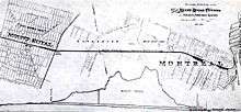
Town of Mount Royal, or TMR, was founded in 1912. It was created at the initiative of the Canadian Northern Railway. The town was designed by Frederick Todd, a planner who was heavily influenced by the likes of Ebenezer Howard and incorporated many aspects of the Garden City Movement as well some elements of the earlier City Beautiful movement into his design.[9] The plan was to build a model city at the foot of Mount Royal. The company bought 4,800 acres (1,900 ha) of farmland, and then built a rail tunnel under Mount Royal connecting their land to downtown Montreal. The profits from the venture helped finance the development of Canadian Northern's transcontinental railroad, which eventually became a significant constituent of the Canadian National Railway system. The town was designed by Canadian Northern's chief engineer, Henry Wicksteed, based loosely on Washington, D.C.
TMR has always been an upper-income community, and until the 1960s its population was majority Anglophone. This began to change after the Quiet Revolution, as francophones gained access to better-paying careers. The town became popular and today the community is 46% francophone and home to a significant Arab and Asian Canadian population.
On January 1, 2002, as part of the 2002–2006 municipal reorganization of Montreal, it was merged into Montreal and became a borough. However, after a change of government and a 2004 referendum, it was re-constituted as an independent town on January 1, 2006.
One notable feature of the town is the naming of some of its streets, and also its occasionally idiosyncratic numbering system. Some streets which pass through the town may thus bear two names (in whichever language). For example, Jean Talon Street, a large East-West thoroughfare crossing Montreal for kilometers, goes a few hundred meters through TMR under the name of Dresden Avenue, only to recover its Montreal name on the other side of the town. This situation has been recently addressed by putting the two names on the street signs. On these few hundred meters, TMR uses a house civic numbering totally different from that of Montreal on either side. This sort of change in the numbering system also occurs on smaller streets shared by both Montreal and TMR (for example, Trenton, Lockhart and Brookfield avenues, where the TMR numbering system decreases from East to West, only to jump from 2 to 2400 on the few meters of the street that still belong to Montreal.
Geography

Two main thoroughfares, Laird Boulevard and Graham Boulevard, cut across the borough diagonally and meet at Connaught Park, a green space located in the centre. Mount Royal Train Station, a commuter train station on the RTM Deux-Montagnes line is located to the east of this park. This line is now undergoing construction to upgrade it for the new REM network. Trains going through the Mount Royal Tunnel link the station to downtown Montreal in eight minutes. Both avenues end at Jean Talon Street and close to the highway.
TMR is surrounded on three sides by a highway, a fence and a rail line.
The highway is Metropolitan Boulevard, a major constituent of Autoroute 40. It was built as an elevated highway throughout, except when it passes through TMR (between Sainte Croix Avenue and L'Acadie Boulevard), since the Town council requested that it be built on the ground, in order to separate the town from the industrial area to the north.
A fence runs along the eastern border with Park Extension at L'Acadie Boulevard, a six lane thoroughfare. The stated purpose of the fence is to prevent children and house pets from running into the busy thoroughfare but some have contended that it was built to keep residents of the working-class Park Extension neighbourhood out of the town.[10][11]
The rail line is the last portion of Canadian Pacific's Adirondack subdivision. It originally ran through the northern part of the district of Côte-des-Neiges. However, when the town became part of Montreal on Jan 1, 2002, the part of Côte-des-Neiges north of rail line was incorporated into the Mount Royal borough. When the town demerged on Jan 1, 2006 this part, known as Glenmount, reverted to Côte-des-Neiges.
Government
Previous mayors
The first mayor of the town of Mount-Royal was Thomas S. Darling, who was elected in 1913.[12]
Municipal
Philippe Roy was elected mayor by acclamation in a by-election in 2010, then again in a general election in 2013. TMR is divided into six electoral districts. Only the Town mayor sits on the agglomeration council of Montreal.[13]
- Joseph Daoura (District No. 1)
- Minh-Diem Le Thi (District No. 2)
- Erin Kennedy (District No. 3)
- John Miller (District No. 4)
- Michelle Setlakwe (District No. 5)
- Jonathan H. Lang (District No. 6)
Federal and Provincial
The entire borough is located within the federal riding of Mount Royal, whose best-known MP for nearly 20 years was Pierre Trudeau, and within the smaller provincial electoral district of Mount Royal.
Demographics
| Historical populations | ||
|---|---|---|
| Year | Pop. | ±% |
| 1966 | 21,845 | — |
| 1971 | 21,560 | −1.3% |
| 1976 | 20,514 | −4.9% |
| 1981 | 19,247 | −6.2% |
| 1986 | 18,350 | −4.7% |
| 1991 | 18,212 | −0.8% |
| 1996 | 18,282 | +0.4% |
| 2001 | 18,682 | +2.2% |
| 2006 | 18,933 | +1.3% |
| 2011 | 19,503 | +3.0% |
| 2016 | 20,276 | +4.0% |
| [14] | ||
Note: Percentages may not add up to 100 percent due to rounding of data samples.
As of the census of 2001,[15] there were 18,682 people, 7,065 households, and 5,215 families residing in the town. The population density was 2,438.90/km². There were 7,267 housing units at an average density of 948.69/km². The racial makeup of the town was 84.51% White, 1.71% Black Canadian, 0.08% Aboriginal, 6.66% Asian Canadian, and 0.84% Latin American.
Languages
| Language(s) | 2016 | 2011 | 2006 | 2001 |
|---|---|---|---|---|
| Percentage (%) | Percentage (%) | Percentage (%) | Percentage (%) | |
| Both English and French | 78% | 77.2% | 77.6% | 76.9% |
| English only | 9.1% | 9.9% | 10.1% | 11.6% |
| French only | 11.2% | 11.7% | 11.1% | 10.1% |
| Neither English nor French | 1.6% | 1.3% | 1.2% | 1.4% |
The 2006 census found that, counting single responses only, French was spoken as a mother tongue by 43.9% of the population, which was a decrease from 46.4% in 2001. English was spoken as a mother tongue by a total of 21.8% of the population in 2006, which was a decrease from 26.2% in 2001. Counting single responses only, the next most common mother tongues were Arabic (7.3%), Greek (3.1%), Italian (3.0%), Armenian and Chinese (2.5% each), and Vietnamese (2.4%).[18]
| Mother tongue | Population (2006) | Percentage (2006) | Population (2011) | Percentage (2011) | Population (2016) | Percentage (2016) |
|---|---|---|---|---|---|---|
| French | 8,185 | 43.86% | 8,475 | 44.04% | 8,740 |
43.68% |
| English | 4,060 | 21.76% | 3,960 | 20.58% | 3,705 |
18.52% |
| English and French | 225 | 1.21% | ||||
| English and a non-official language | 210 | 1.13% | ||||
| French and a non-official language | 160 | 0.86% | ||||
| English, French and a non-official language | 55 | 0.29% | ||||
| Arabic | 1,355 | 7.26% | ||||
| Greek | 570 | 3.05% | ||||
| Italian | 555 | 2.97% | ||||
| Armenian | 465 | 2.49% | ||||
| Chinese | 460 | 2.47% | ||||
| Vietnamese | 445 | 2.38% | ||||
| Romanian | 280 | 1.50% | ||||
| Spanish | 155 | 0.83% | ||||
| Persian | 155 | 0.83% | ||||
| Russian | 145 | 0.78% | ||||
| German | 125 | 0.67% | ||||
| Korean | 95 | 0.51% | ||||
| Polish | 85 | 0.46% | ||||
| Hungarian | 80 | 0.43% | ||||
| Tagalog | 75 | 0.40% | ||||
| Creole | 60 | 0.32% | ||||
| Tamil | 60 | 0.32% | ||||
| Gujarati | 45 | 0.24% | ||||
| Ukrainian | 45 | 0.24% | ||||
| Portuguese | 40 | 0.21% | ||||
| Hebrew | 35 | 0.19% | ||||
| Yiddish | 35 | 0.19% | ||||
| Bulgarian | 30 | 0.16% | ||||
| Czech | 25 | 0.13% | ||||
| Kurdish | 25 | 0.13% | ||||
| Slovak | 25 | 0.13% | ||||
| Language | Population (2006) | Percentage (2006) | Population (2011) | Percentage (2011) | Population (2016) | Percentage (2016) |
|---|---|---|---|---|---|---|
| French | 9,145 | 49.02% | 9,070 | 47.14% | 9,350 |
46.73% |
| English | 6,375 | 34.17% | 5,950 | 30.93% | 5,585 |
27.91% |
| Both English and French | 395 | 2.12% | 385 | 2.00% | 430 |
2.15% |
| Other languages | 2,745 | 14.71% | 3,020 | 15.70% | 3,560 |
17.79% |
Age
In the town the population was spread out with 18.7% under the age of 15, 11.6% from 15 to 24, 24.8% from 25 to 44, 26.0% from 45 to 64, and 19.0% who were 65 years of age or older. The median age was 41 years. For every 100 females there were 89.2 males. For every 100 females age 15 and over, there were 85.9 males.
Households
There were 7,065 households out of which 33.7% had children living with them, 57.6% were married couples living together, 7.2% had a female lone-parent as a householder, and 25.8% of all households were made up of individuals. The average married-couple family size was 3.2.
Religion
As of 2001, Christians made up 71.9% of the population, or 53.2% Catholic, 6.0% Protestant, 10.9% Orthodox, and 1.8% other Christian. Other religions in the town include 12% Jewish, 5.5% Muslim, 2.3% Buddhist, and 0.6% other religions. 7.6% of the population claimed to have no religious affiliation.[19]
Income
As of 2006, the median income for a household in the town was $86,743 CAD, and the median income for a family was $112,449 CAD. Males had an average income of $86,428 CAD versus $41,883 CAD for females. About 4.5% of the labour force was unemployed. The largest occupation categories were 20.7% employed in management occupations, 20.3% business, finance, and administration occupations, and 17.9% in sales and service occupations.
Education
The Commission scolaire Marguerite-Bourgeoys (CSMB) operates Francophone public schools.[20]
Secondary schools:
- École secondaire Mont-Royal
- École secondaire Pierre-Laporte
Primary schools:
- École primaire Académie Saint-Clément
- École primaire Saint-Clément Ouest
- École primaire Saint-Clément Est
The English Montreal School Board (EMSB) operates Anglophone public schools in the town.
The Town has its own library, Reginald J. P. Dawson Library, which is independent from the Montreal Library Network.
See also
- List of enclaves
- List of former boroughs
- Montreal Merger
- Municipal reorganization in Quebec
References
- "List of the official municipalities of Québec". Gouvernement du Québec. 2012. Archived from the original on 5 February 2012. Retrieved 24 September 2012.
- "Ville de Mont-Royal - Town of Mount Royal (Homepage)". Town of Mount-Royal. 24 September 2012. Retrieved 24 September 2012.
- Reference number 388468 of the Commission de toponymie du Québec (in French)
- "Ministère des Affaires municipales, des Régions et de l'Occupation du territoire: Mont Royal". Archived from the original on 2012-05-01. Retrieved 2012-03-11.
- Parliament of Canada Federal Riding History: MOUNT ROYAL (Quebec)
- 2011 Statistics Canada Census Profile: Mount Royal, Quebec
- Statistics Canada (2017). "Mont-Royal, V [Census subdivision], Quebec. Census Profile. 2016 Census". Retrieved 2018-04-16.
- "Model City of Mount Royal". Directory of Designations of National Historic Significance of Canada. Parks Canada. Retrieved November 30, 2011.
- Sewell, John. "The Shape of the City: Toronto Struggles with Modern Planning" page 52 University of Toronto Press Inc. 1993
- Kristian Gravenor, "Segregation fence to live on." Montreal Mirror, November 8, 2001. Archived July 1, 2012, at the Wayback Machine
- Photographer gets hassled by municipal security.
- 1943-, Kalbfleisch, John (2013). Le cadeau royal : histoire de la ville de Mont-Royal = The royal gift : a history of Town of Mount Royal. Town of Mount Royal, QC: Town of Mount Royal. p. 4. ISBN 9782980472732. OCLC 846793989.CS1 maint: numeric names: authors list (link)
- "Town Council | A garden city". www.ville.mont-royal.qc.ca. Retrieved 2018-06-03.
- "Profil sociodémographique: Ville de Mont-Royal" (PDF) (in French). Ville de Montréal. 2013. Retrieved 28 October 2013.
- Statistics Canada (2007-01-02). "2001 Community Profiles: Community Highlights for Mont-Royal". Statistics Canada. Retrieved 2007-12-01.
- Statistics Canada (2007-03-13). "2006 Community Profiles: Community Highlights for Mont-Royal". Statistics Canada. Retrieved 2007-12-04.
- Statistics Canada. "Language Composition of Canada: Knowledge of Official Languages". Statistics Canada. Retrieved 2007-12-01.
- "Mont-Royal, V". Detailed Mother Tongue (103), Knowledge of Official Languages (5), Age Groups (17A) and Sex (3) for the Population of Canada, Provinces, Territories, Census Divisions and Census Subdivisions, 2006 Census - 20% Sample Data. Statistics Canada. 2007-11-20. Retrieved 2008-02-06.
- "2001 Community Profiles — Population". Canada 2006 census. Statistics Canada. 2001. Retrieved 26 July 2010.
- "ÉCOLES ET CENTRES." Commission Scolaire Marguerite-Bourgeoys. Retrieved on December 7, 2014.
- Carlyle Elementary School
- École Dunrae Gardens School
External links
| Wikimedia Commons has media related to Mont-Royal, Quebec. |
- Official website
- Model City of Mount Royal. Canadian Register of Historic Places. Retrieved 5 February 2012.
Places adjacent to Mount Royal, Quebec | ||||||||||
|---|---|---|---|---|---|---|---|---|---|---|
| ||||||||||
| Provinces | |
|---|---|
| Territories | |
| Other countries | |
| |