Deux-Montagnes line
Deux-Montagnes or Two Mountains Line (also designated exo6 and formerly Red Line) is a commuter railway line in Greater Montreal, Quebec, Canada. It is owned by Exo, the organization that operates public transport services across this region.
| Deux-Montagnes | |||
|---|---|---|---|
 Line portion between Canora and Mont-Royal | |||
| Overview | |||
| Type | Commuter rail | ||
| System | Exo | ||
| Locale | Greater Montreal | ||
| Termini | Bois-Franc Deux-Montagnes | ||
| Stations | 12 | ||
| Daily ridership | 28,015 (2018)[1] | ||
| Ridership | 7,284,100 (2018) | ||
| Line number | DM | ||
| Website | Exo – Deux-Montagnes line | ||
| Operation | |||
| Opened | 1918 | ||
| Operator(s) | Bombardier | ||
| Technical | |||
| Line length | 29.9 km (18.6 mi)[2] | ||
| Track gauge | 1,435 mm (4 ft 8 1⁄2 in) standard gauge | ||
| Electrification | 25 kV AC 60 Hz Catenary | ||
| |||

Deux-Montagnes line | |||||||||||||||||||||||||||||||||||||||||||||||||||||||||||||||||||||||||||||||||||||||||||||||||||||||||||||||||||||||||||||||||||||||||||||||||||||||||||||||||||||||||||||||||||||||||||||||||||||||||||||||||||||||||||||||||||||||||||||||||||||||
|---|---|---|---|---|---|---|---|---|---|---|---|---|---|---|---|---|---|---|---|---|---|---|---|---|---|---|---|---|---|---|---|---|---|---|---|---|---|---|---|---|---|---|---|---|---|---|---|---|---|---|---|---|---|---|---|---|---|---|---|---|---|---|---|---|---|---|---|---|---|---|---|---|---|---|---|---|---|---|---|---|---|---|---|---|---|---|---|---|---|---|---|---|---|---|---|---|---|---|---|---|---|---|---|---|---|---|---|---|---|---|---|---|---|---|---|---|---|---|---|---|---|---|---|---|---|---|---|---|---|---|---|---|---|---|---|---|---|---|---|---|---|---|---|---|---|---|---|---|---|---|---|---|---|---|---|---|---|---|---|---|---|---|---|---|---|---|---|---|---|---|---|---|---|---|---|---|---|---|---|---|---|---|---|---|---|---|---|---|---|---|---|---|---|---|---|---|---|---|---|---|---|---|---|---|---|---|---|---|---|---|---|---|---|---|---|---|---|---|---|---|---|---|---|---|---|---|---|---|---|---|---|---|---|---|---|---|---|---|---|---|---|---|---|---|---|---|---|
| |||||||||||||||||||||||||||||||||||||||||||||||||||||||||||||||||||||||||||||||||||||||||||||||||||||||||||||||||||||||||||||||||||||||||||||||||||||||||||||||||||||||||||||||||||||||||||||||||||||||||||||||||||||||||||||||||||||||||||||||||||||||
The line was created in 1918 as a Canadian Northern Railway (CNoR) service. Canadian National Railway (CN) ran the line starting in 1923 following the merger of CNoR into CN. CN transferred the Deux-Montagnes Line to the Société de transport de la communauté urbaine de Montréal (STCUM) on July 1, 1982. The line was refurbished from 1992 to 1995. It was transferred to the RTM's predecessor agency, the Agence Métropolitaine de transport (AMT) on January 1, 1996. The RTM assumed current operation of the line upon its establishment on June 1, 2017.
On May 11, 2020, service between Bois-Franc and Montreal Central Station was closed due to the construction of Réseau express métropolitain (REM).[3] In the early 2020s, the Deux-Montagnes line will close permanently in favour of REM service which will operate along the same route.
Overview
This line links Central Station in downtown Montreal with Deux-Montagnes to the northwest of the Island of Montreal.
The line offers frequent service during rush hours (10–30 minute intervals) and hourly service outside rush hours on weekdays. Since April 27, 2018, weekend service on the line had been shut down. Prior, there was hourly service on weekends.[4]
The trains are owned and managed by the RTM and are operated by Bombardier Transportation.[5]
Deux-Montagnes, Roxboro-Pierrefonds, and Central Station are wheelchair-accessible.[6]
In 2016 an average of 30,700 people rode this train daily, having almost as many passengers as Montreal's four other commuter railway lines combined. There are 25 inbound and 24 outbound departures each weekday.[7]
On April 22, 2016, it was announced that the Deux-Montagnes line would be converted from commuter rail to automated light metro in 2020, as part of the Réseau express métropolitain network.[8]
History
CN service

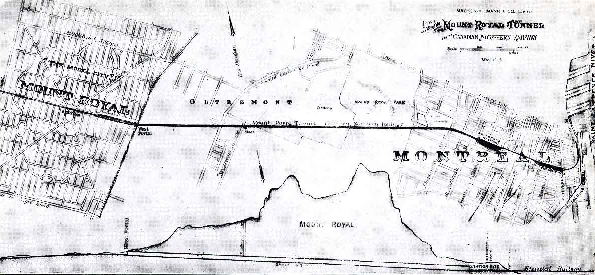
The Deux-Montagnes line was built by the Canadian Northern Railway. While other railways including Canadian Pacific and Grand Trunk Railway already had prime downtown locations for their terminal stations, Canadian Northern did not, having only a station out of the way on Moreau Street in Hochelaga.
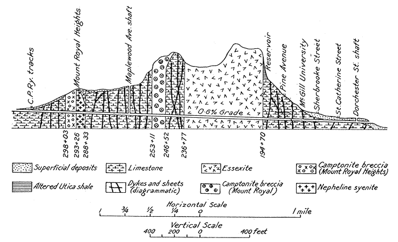
In 1910, it was decided that the best way for Canadian Northern to get downtown was to drill their way downtown — through Mont Royal. The construction started at both ends and met halfway through with only an inch difference. In 1918 the electrified (2400 V DC catenary), double-track 3.2 mi (5.15 km) tunnel was dubbed Montreal's first subway. Because the tunnel is on a steep grade and inadequately ventilated[9][10] it was decided from the very beginning that the locomotives would be electric. The ventilation shaft is located SW of the intersection of Édouard-Montpetit Boulevard and Vincent-d'Indy Avenue very close to the Édouard-Montpetit Metro Station.[11][12]
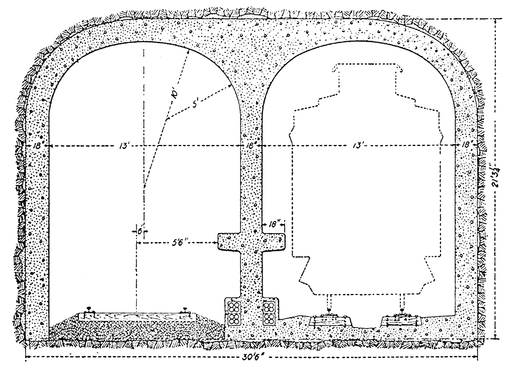
The structure gauge of the Mount Royal Tunnel limits the height of bilevel cars to 14 ft 6 in or 4.42 m.[13]

In order to finance the project, Canadian Northern built a ‘model city’ north of the tunnel, modeled after Washington, D.C. The Town of Mount-Royal has grown to be an upper-income neighbourhood today. Construction began in 1912 and finished in 1918.[15] The first train was pulled by electric locomotive #601 (retired as #6711), which left Tunnel Terminal at 8:30 a.m. on October 21, 1918. The Canadian Northern Railway went bankrupt and was absorbed into what is now Canadian National. Tunnel Terminal was replaced by Central Station in 1943. CN added electric multiple units from Canadian Car and Foundry in 1952.[16]
.jpg)
In the 1960s, the first plans were announced to renovate the line, whose equipment was 40 years old at the time. First, it was to become metro line 3 (red), but plans were shelved because of the importance to build line 4 for service to Expo 67. With the equipment ageing, and ridership declining, CN wanted to close the line in the 1970s, but their proposals were rejected. The Quebec Ministry of Transport considered using the line for a high-speed connection to Mirabel Airport (Transport rapide régional aéroportuaire Montréal Mirabel, 1974) or as the first line of a BART-style regional metro system (Réseau express de Montréal, 1977; Métro régional, 1979). None of these projects progressed beyond the planning stage.
STCUM and AMT service
In 1982, management of commuter trains was transferred to the publicly owned Montreal Urban Community Transit Commission (STCUM). The STCUM set fares and schedules, while the Canadian National retained ownership of the equipment (passenger cars and locomotives). CN continued to provide the tracks, stations, storage, maintenance, and train crews needed to keep the line running. For Montreal commuters, the transfer of ownership was positive because the trains were integrated into the bus and metro system.
In 1992, the government of Quebec announced a modernisation plan for the line which would include electrifying the entire line at 25 kV AC (and converting the existing catenary in the Mont-Royal Tunnel to this voltage), 58 state-of-the-art MR-90 electric multiple unit trains built by Bombardier Transportation, new tracks, and centralised traffic control. Service was shut down completely in the summers of 1993, 1994 and 1995 to allow for major work to be done. The last of the old rolling stock left Central Station at 6:30 p.m. on June 2, 1995 – 76 years, 8 months, 11 days, and ten hours after it first went into service. The same locomotive, #6711 (with #6710 (pictured)), hauled the last train through the tunnel.
The line was transferred to the former Agence métropolitaine de transport (AMT) on January 1, 1996.
Exo service
On June 1, 2017, the AMT was dissolved and replaced by two new governing bodies, the Autorité régionale de transport métropolitain (ARTM) and the Réseau de transport métropolitain (RTM). The RTM took over all former AMT services, including this line.
In May 2018, the RTM formally re-branded itself as Exo; and renamed each line with a number and updated colour. The Deux-Montagnes line became Exo 6, and the blue line colour was updated to a light peach colour.
Future projects
To ease overcrowding and attract new users on the Deux-Montagnes Line, the ARTM is carrying out several projects:
- Extending the double track from its current endpoint at the Bois-Franc station to the Roxboro-Pierrefonds station in Pierrefonds-Roxboro. Work includes doubling the track over 7.5 km parallel to the existing track, rebuilding a small bridge, building a new overpass over the bike path through Bois-de-Liesse park, reconfiguring three level crossings, and adding a second platform at Sunnybrooke station. Construction was to have begun in 2013 and was to be completed by 2015 but as of 2017 work has not yet begun. Preliminary costs are estimated at $51 million.[17][18]
- Open a new train station at Autoroute 13 near boulevard Gouin (between Bois-Franc and Sunnybrooke stations). The project is subject to an increase on the line's capacity, pushing its commissioning date to 2018 or later.
Under the Réseau express métropolitain project, the Deux-Montagnes line is being converted to driverless light metro operation and extended past Downtown and over the St-Lawrence to Brossard; two southwest branches will also be added, to Montreal-Pierre Eliott Trudeau International Airport and to Sainte-Anne-de-Bellevue.[8]
Current status
- CN built a railway overpass to route its Saint-Laurent subdivision over the commuter train line just south of Montpellier station. The overpass was a prerequisite for increasing commuter train frequencies on the Deux-Montagnes line as well as the commissioning of the Mascouche line. The $60 million project was begun in 2010 and was completed by the end of 2013, when the new line also was commissioned.[19]
- On February 28, 2014, the AMT announced that it had purchased the Deux-Montagnes line from CN for a sum of $92 million. While CN owned the line, freight trains could use it within two time windows: during the day from 08:30 to 15:30 and during the night from 20:30 to 05:30. Purchasing the line allowed AMT to give commuter trains priority all day, between 05:30 and 20:30.[20] This gave the AMT flexibility for scheduling trains and allows it to save rent money in the long term.
List of stations
As of May 2020, only the stations between Deux-Montagnes and Bois-Franc are in operation. The following stations are on the Deux-Montagnes line:
| Station | Location | Connections | Zones |
|---|---|---|---|
| Central Station | Ville-Marie, Montreal | Via Rail, Amtrak, and Downtown Terminus (Terminus RTL). Bonaventure metro station, Société de transport de Montréal (STM) 150, 355, 358, 410, 430, 465, 480 (Express), 715, 747 (Express), (within walking distance along René Lévesque Boulevard), 35, 36, 61, 168, 420 (On University Street), 74 (On rue de la Gauchetière), 107 (on Peel Street).[21] | 1 |
| Canora | Côte-des-Neiges–Notre-Dame-de-Grâce, Montreal | STM 92 on Jean Talon Street, 160 (less than 200 metres or 220 yards south at Wilderton Ave. / Bates Rd. east bound & Wilderton Ave. / Barclay St. west bound[22] ), 372 on Jean Talon Street. | |
| Mont-Royal | Mount Royal | STM 16, 119, 165, 435. | |
| Montpellier | Saint-Laurent, Montreal | STM 121, 128, 171, 378, 380. | |
| Du Ruisseau | border of Saint-Laurent and Ahuntsic-Cartierville, Montreal | STM 117, 135. STL (Laval) 55 | 2 |
| Bois-Franc | Saint-Laurent, Montreal | STM 64, 126, 164, 170, 215, 382, 468, 964 (Express). STL Routes 55, 144, 151. former AMT, now STL, Express route 902. | 2 |
| Sunnybrooke | Pierrefonds-Roxboro, Montreal | STM 68, 213, 382 on Gouin Boulevard in Pierrefonds-Roxboro, 468, 968 (Express), STM 208 on the other side of the track on rue Cérès in Dollard-des-Ormeaux and STM 356 on Sunnybrooke Boulevard | |
| Roxboro-Pierrefonds | Pierrefonds-Roxboro, Montreal | STM 68, 205, 206, 208, 209, 213, 407 (Express),[23] 382, 468, 968 (Express). | |
| Île-Bigras | Île Bigras, Îles Laval, Laval | STL No buses. | 3 |
| Sainte-Dorothée | Sainte-Dorothée, Laval | STL Routes 26, 76, 402, 404, 903.[24][25] | |
| Grand-Moulin | Deux-Montagnes | CIT Laurentides[26] 93 | 5 |
| Deux-Montagnes | CIT Laurentides Routes 80, 81, 89, 90, 92, 93, 400, 404 (Express) |
As of January 9, 2012 many bus line number have changed.[27]
Geography
The Deux-Montagnes line uses the former CN Deux-Montagnes Subdivision between mile 0.8 (Central Station) and 19.4 (Deux-Montagnes). The RTM now owns it.[20]
The line runs through the Mount Royal Tunnel, to connect downtown Montreal, to the north side rail subdivision.
On the line lay the Val Royal Bridge rail viaduct, once the world's largest concrete span, next to Val Royal Station (now Bois-Franc station)[28]
See also
- ALP-45DP
- Canadian Northern Railway
- List of Montreal bus routes
- Line 3 Red (Montreal Metro)
- MR-90
- Réseau express métropolitain
References
- https://exo.quebec/Media/Default/pdf/section8/publications/RA_2018_exo.pdf
- "Rapport d'activités 2010" (PDF) (in French). Agence métropolitaine de transport. 2011. Retrieved 12 January 2012.
- Thomas, Katelyn (May 11, 2020). "Here's how to get around the Mount Royal tunnel closure". CTV News Montreal. Retrieved May 17, 2020.
- "Horaire Montreal/Deux-Montagnes" (PDF). RTM. 2017. Retrieved 2017-07-14.
- http://globalnews.ca/news/3082429/bombardier-signs-deal-to-operate-montreals-amt-network/
- Lève-personne pour la clientèle en fauteuil roulant maintenant en service à la gare Deux-Montagnes Archived 2008-05-12 at the Wayback Machine
- "Deux-Montagnes In brief". Retrieved 2020-05-21.
- Jason Magder (April 22, 2016). "Electric light-rail train network spearheaded by Caisse de dépôt to span Montreal by 2020". Montreal Gazette. Retrieved April 23, 2016.
- "Une virée dans le puits de ventilation du tunnel Mont-Royal". Marc Dufour. 2006. Retrieved 2006-12-26.
- "Le tunnel, à l'arrivée du puits de ventilation". Marc Dufour. 2006. Retrieved 2006-12-26.
- "Carte du Tunnel". Marc Dufour. 2006. Retrieved 2006-12-26.
- "Coupe Geologique". Marc Dufour. 2006. Retrieved 2006-12-26.
- "Coupe Tunnel Double". Marc Dufour. 2006. Retrieved 2006-12-26.
- Transvert Group. "Doney Spur Commuter Rail Line" (PDF).
- "Mount Royal Line Opened To Public" Montreal Gazette. October 22, 1918.
- "Items of interest" (PDF). Canadian Rail (28). September–October 1952.
- Montreal Gazette dead link]
- "AMT PTI 2012-1013-2014" (PDF). Archived from the original (PDF) on February 11, 2013.
- "Rapport d'activités" (PDF). AMT. 2011. Archived from the original (PDF) on January 6, 2014.
- Riga, Andy (February 28, 2014). "AMT purchases Deux-Montagnes rail line from CN for $92 million". Montreal Gazette. Archived from the original on March 16, 2014.
- Maps
- Map
- 265(TB) renamed 407 Archived 2012-01-15 at the Wayback Machine
- "Plan du Reseau STL 2008" (PDF). STL. 2008. Archived from the original (PDF) on 2008-04-10. Retrieved 2008-02-21.
- STL 2011 map Archived September 20, 2011, at the Wayback Machine
- "CIT Laurentides". CIT Laurentides. 2006. Archived from the original on 2006-12-30. Retrieved 2006-12-26.
- Will your bus line number change ? Archived 2012-01-15 at the Wayback Machine
- "Val Royal Bridge". Civil Engineering and Public Works Review. Lomax, Erskine & Company. XXXVI (416). 1941.
External links
| Wikimedia Commons has media related to Deux-Montagnes line. |