Mount Murray (Alberta)
Mount Murray is a 3,026-metre (9,928-foot) mountain summit in the Spray Mountains range of the Canadian Rockies in Alberta, Canada.[2] The mountain is situated in Peter Lougheed Provincial Park of Kananaskis Country. Its nearest higher peak is Mount French, 2.0 km (1.2 mi) to the south-southwest.[1] Mount Murray can be seen from Alberta Highway 742, the Smith-Dorrien/Spray Trail.
| Mount Murray | |
|---|---|
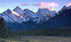 Mount Murray to left of center. (Mount French right of center under cloud) | |
| Highest point | |
| Elevation | 3,026 m (9,928 ft) [1] |
| Prominence | 313 m (1,027 ft) [1] |
| Parent peak | Mount French (3244 m)[1] |
| Coordinates | 50°44′57″N 115°17′35″W [2] |
| Geography | |
 Mount Murray Location of Mount Murray in Alberta  Mount Murray Mount Murray (Canada) | |
| Location | Alberta, Canada |
| Parent range | Spray Mountains Canadian Rockies |
| Topo map | NTS 82J11/82J14 |
| Geology | |
| Age of rock | Cambrian |
| Type of rock | sedimentary rock |
| Climbing | |
| Easiest route | Scrambling[1] [3] |
History
The mountain was named in 1918 for General Sir A. J. Murray, (1860-1945).[4] Murray was a British Army officer who served in the Second Boer War and the First World War as Commander-in-Chief of the Egyptian Expeditionary Force from 1916-1917.
The mountain's name was officially adopted in 1928 by the Geographical Names Board of Canada.[2]
Geology
Mount Murray is composed of sedimentary rock laid down during the Precambrian to Jurassic periods. Formed in shallow seas, this sedimentary rock was pushed east and over the top of younger rock during the Laramide orogeny.[5]
Climate
Based on the Köppen climate classification, Mount Murray is located in a subarctic climate with cold, snowy winters, and mild summers.[6] Temperatures can drop below −20 °C with wind chill factors below −30 °C. In terms of favorable weather conditions, July to September are best for climbing.
References
- "Mount Murray". Bivouac.com. Retrieved 2019-01-09.
- "Mount Murray". Geographical Names Data Base. Natural Resources Canada. Retrieved 2019-01-09.
- Scrambles in the Canadian Rockies, Alan Kane, 3rd edition, page 132
- Place-names of Alberta. Ottawa: Geographic Board of Canada. 1928. p. 91.
- Gadd, Ben (2008). "Geology of the Rocky Mountains and Columbias". Cite journal requires
|journal=(help) - Peel, M. C.; Finlayson, B. L. & McMahon, T. A. (2007). "Updated world map of the Köppen−Geiger climate classification". Hydrol. Earth Syst. Sci. 11: 1633–1644. ISSN 1027-5606.
External links
- Mount Murray weather: Mountain Forecast
- Mount Murray climbing photos: Expor8ion.com
- Mt. Murray photo: Flickr