Mount Foch
Mount Foch is a 3,194-metre (10,479-foot) mountain summit located on the border of Alberta and British Columbia on the Continental Divide. It was named in 1918 after Marshall Ferdinand Foch.[1][2] The first ascent of the mountain was made in 1930 by Kate (Katie) Gardiner and Walter Feuz.[3] The duo also made the first ascents of nearby Mount Sarrail and Mount Lyautey that same year.[4]
| Mount Foch | |
|---|---|
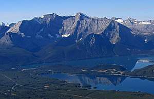 Mounts Foch and Sarrail | |
| Highest point | |
| Elevation | 3,194 m (10,479 ft) [1] |
| Prominence | 384 m (1,260 ft) |
| Coordinates | 50°34′24″N 115°09′30″W |
| Geography | |
 Mount Foch Location in Alberta and British Columbia | |
| Location | Alberta British Columbia |
| Topo map | NTS 82J/11 |
| Climbing | |
| First ascent | 1930 Katie Gardiner, Walter Fuez |
Geology
Mount Foch is composed of sedimentary rock laid down during the Precambrian to Jurassic periods. Formed in shallow seas, this sedimentary rock was pushed east and over the top of younger rock during the Laramide orogeny.[5]
Climate
Based on the Köppen climate classification, Mount Foch is located in a subarctic climate with cold, snowy winters, and mild summers.[6] Temperatures can drop below −20 C with wind chill factors below −30 C. In terms of favorable weather, June through September are the best months to climb Mount Foch.
See also
- List of peaks on the British Columbia-Alberta border
- Mountains of Alberta
- Mountains of British Columbia
References
- PeakFinder
- Mount Foch
- "Mount Foch". Bivouac.com. Retrieved 2018-12-15.
- Mount Foch PeakFinder
- Gadd, Ben (2008). "Geology of the Rocky Mountains and Columbias". Cite journal requires
|journal=(help) - Peel, M. C.; Finlayson, B. L. & McMahon, T. A. (2007). "Updated world map of the Köppen−Geiger climate classification". Hydrol. Earth Syst. Sci. 11: 1633–1644. ISSN 1027-5606.
External links
- Mount Foch weather: Mountain Forecast