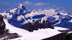
Mistaya Mountain
Mistaya Mountain is located on the border of Alberta and British Columbia, on the Continental Divide. It was named in 1918.[1][2] Mistaya is the Cree name for "grizzly bear".[5] Mistaya is an easyish, non-technical mountain with good views especially to the north, north-west and south.
| Mistaya Mountain | |
|---|---|
 | |
| Highest point | |
| Elevation | 3,096 m (10,157 ft) [1] |
| Prominence | 366 m (1,201 ft) [2] |
| Listing | Mountains of Alberta Mountains of British Columbia |
| Coordinates | 51°42′41″N 116°35′06″W [3] |
| Geography | |
 Mistaya Mountain Location in Alberta and British Columbia  Mistaya Mountain Mistaya Mountain (British Columbia) | |
| Country | Canada |
| Provinces | Alberta and British Columbia |
| Topo map | NTS 82N/10[3] |
| Climbing | |
| First ascent | July 21, 1933 by H.S. Kingman, J. Monroe Thorington, C. Kain[4][2] |
See also
- List of peaks on the British Columbia-Alberta border
References
- "Mistaya Mountain". PeakFinder.com. Retrieved 2019-08-25.
- "Mistaya Mountain". Bivouac.com. Retrieved 2019-08-26.
- "Mistaya Mountain (AB)". Geographical Names Data Base. Natural Resources Canada. Retrieved 2019-08-26.
- Thorington, J. Monroe (1966) [1921]. "Kicking Horse Pass to Howse Pass". A Climber's Guide to the Rocky Mountains of Canada. With the collaboration of Putnam, William Lowell (6th ed.). American Alpine Club. p. 146. ISBN 978-1376169003.
- Fromhold, Joachim (2012). 2001 INDIAN PLACE NAMES OF THE WEST, Part 2: Listings by Nation. Retrieved 2019-08-26.
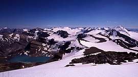
View from Mistaya: the Wapta Icefield
This article is issued from Wikipedia. The text is licensed under Creative Commons - Attribution - Sharealike. Additional terms may apply for the media files.