Metropolitan Borough of Rochdale
The Metropolitan Borough of Rochdale is a metropolitan borough of Greater Manchester in North West England. It is named after its largest town, Rochdale, but spans a far larger area which includes the towns of Middleton, Heywood, and the villages of Wardle, Littleborough and Milnrow
Borough of Rochdale | |
|---|---|
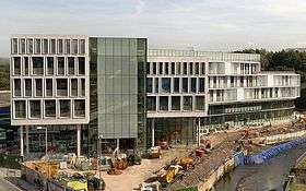 Number One Riverside, Rochdale | |
 Coat of Arms of the Borough Council | |
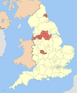
 Rochdale shown within Greater Manchester and England | |
| Sovereign state | United Kingdom |
| Constituent country | England |
| Region | North West England |
| Ceremonial county | Greater Manchester |
| Admin HQ | Rochdale (Town Hall) |
| Founded | 1 April 1974 |
| Government | |
| • Type | Metropolitan borough |
| • Governing body | Rochdale Metropolitan Borough Council |
| • Mayor | Cllr. Ian Duckworth |
| • MPs: | Tony Lloyd (L) Chris Clarkson (C) |
| • Council Leader | Cllr. Allen Brett |
| Area | |
| • Total | 61.4 sq mi (159 km2) |
| Population (mid-2019 est.) | |
| • Total | 222,412 (Ranked 79th) |
| • Density | 3,521/sq mi (1,359/km2) |
| • Ethnicity (United Kingdom Estimate 2006) [1] | 86.5% White 11.4% S.Asian or mixed 1.4% Black or mixed 0.8% Chinese or other |
| Demonym(s) | Rochdalian |
| Time zone | UTC+0 (Greenwich Mean Time) |
| Postcodes | |
| Area code(s) | 0161 / 01706 |
| ISO 3166-2 | GB-RCH |
| ONS code | 00BQ (ONS) E08000005 (GSS) |
| OS grid reference | SD897133 |
| NUTS 3 | UKD32 |
| Website | www.rochdale.gov.uk |
The borough was formed in 1974 as part of the provisions of the Local Government Act 1972 and is an amalgamation of six former local government districts. It was originally proposed that the borough include the neighbouring town of Bury and disclude Middleton; Bury however went on to form the administrative centre for the adjacent Metropolitan Borough of Bury.
Geography
The borough lies directly north-northeast of the City of Manchester and has a population of 206,500. Although some parts are highly industrialised and densely populated, the borough has the lowest population density in Greater Manchester, with some areas of rural open space including Blackstone Edge and the Pennine hills.
History

The borough, which is the largest such borough of Greater Manchester, was formed on 1 April 1974, under the Local Government Act 1972, by a merger of the former county borough of Rochdale and, from the administrative county of Lancashire, the municipal boroughs of Heywood and Middleton, along with the urban districts of Littleborough, Milnrow and Wardle.
Prior to its creation, it was suggested that the metropolitan borough be named Chadwick (with reference to Sir Edwin Chadwick), but this was rejected in favour of Rochdale.[2]
Neighbouring districts
The Metropolitan Borough of Oldham lies to the south-east, and the Metropolitan Borough of Bury lies to the west. The City of Manchester is to the south.
To the north-west is the borough and non-metropolitan district of Rossendale in Lancashire and to the north-east is the Metropolitan Borough of Calderdale in West Yorkshire.
Unparished areas
Showing former status (prior to 1974)
Ethnic groups[3]
Rochdale(2011) - count - %
- All residents 211,699 - 100.0
- White - 172,874 - 81.7
- English/Welsh/Scottish/Northern Irish/British - 166,481 - 78.6
- Irish - 2,131 - 1.0
- Gypsy or Irish Traveller - 186 - 0.1
- Other White - 4,076 - 1.9
- Mixed/multiple ethnic groups - 3,569 - 1.7
- White and Black Caribbean - 1,057 - 0.5
- White and Black African - 601 - 0.3
- White and Asian - 1,348 - 0.6
- Other Mixed - 563 - 0.3
- Asian/Asian British - 31,630 - 14.9
- Indian - 1,105 - 0.5
- Pakistani - 22,265 - 10.5
- Bangladeshi - 4,342 - 2.1
- Chinese - 948 - 0.4
- Other Asian - 2,970 - 1.4
- Black/African/Caribbean/Black British - 2,770 - 1.3
- African - 2,131 - 1.0
- Caribbean - 285 - 0.1
- Other Black - 354 - 0.2
- Other ethnic group - 856 - 0.4
- Arab - 308 - 0.1
- Any other ethnic group - 548 - 0.3
Source: ONS - 2011 Census (KS201EW)[4]
Population change
The table below details the population change since 1801, including the percentage change since the last available census data. Although the Metropolitan Borough of Rochdale has only existed 1974, figures have been generated by combining data from the towns, villages, and civil parishes that would later be constituent parts of the borough.
| Population growth in Rochdale since 1801 | |||||||||||||||||||||
|---|---|---|---|---|---|---|---|---|---|---|---|---|---|---|---|---|---|---|---|---|---|
| Year | 1801 | 1811 | 1821 | 1831 | 1841 | 1851 | 1861 | 1871 | 1881 | 1891 | 1901 | 1911 | 1921 | 1931 | 1941 | 1951 | 1961 | 1971 | 1981 | 1991 | 2001 |
| Population | 28,689 | 36,815 | 46,440 | 57,377 | 69,956 | 80,317 | 102,247 | 124,177 | 146,107 | 151,490 | 165,617 | 181,061 | 181,227 | 181,395 | 177,574 | 173,833 | 188,316 | 204,071 | 206,351 | 204,802 | 205,233 |
| % change | – | +28.3 | +26.1 | +23.6 | +21.9 | +14.8 | +27.3 | +21.4 | +17.7 | +3.7 | +9.3 | +9.3 | +0.1 | +0.1 | −2.1 | −2.1 | +8.3 | +8.4 | +1.1 | −0.8 | +0.2 |
| Source: Vision of Britain[5] | |||||||||||||||||||||
Twin towns
The Metropolitan Borough of Rochdale has formal twinning arrangements with six places. Three were originally twinned with a place within the Metropolitan Borough boundaries prior to its creation in 1974.[6]
| Country | Place | County / District / Region / State | Originally twinned with | Date | |||
|---|---|---|---|---|---|---|---|
| France | Tourcoing | Nord-Pas de Calais | County Borough of Rochdale | 1956 | |||
| Germany | Peine | Niedersachsen | Municipal Borough of Heywood | 1967 | |||
| Germany | Bielefeld | Nordrhein-Westfalen | County Borough of Rochdale | 1953 | |||
| Pakistan | Sahiwal | Punjab | Metropolitan Borough of Rochdale | 1988 | |||
| Ukraine | Lviv | Lviv | Metropolitan Borough of Rochdale | 1992 | |||
| Bangladesh | Sylhet | Sylhet Division | Metropolitan Borough of Rochdale | 2009 |
Freedom of the Borough
The following people and military units have received the Freedom of the Borough of Rochdale.
Individuals
- Dame Gracie Fields DBE: 6 May 1937.
- Sir Cyril Smith MStJ Kt MBE DL: November 1992. (This honour was revoked by a unanimous vote of the Rochdale Borough Council on 18 October 2018).[7]
- Jim Callaghan: 3 April 1996.
- Lance Corporal Stephen Shaw MC: 17 April 2013.
- Rt. Hon. Lord Barnett PC: 22 January 2014.
- Julie Goodyear MBE: 5 October 2017.
Military Units
- The Lancashire Fusiliers: 5 June 1947.
- The Royal Regiment of Fusiliers: 4 March 1978.
- HMS Middleton, RN: 20 May 1992.
See also
References
Notes
- Lead View Table
- Clark 1973, p. 101.
- Lead View Table
- https://www.nomisweb.co.uk/reports/localarea?compare=E08000005
- "Rochdale District: total population". Vision of Britain. Retrieved on 20 December 2008.
- "Town twinning". rochdale.gov.uk. Archived from the original on 2007-10-29. Retrieved 2011-08-18.
- https://www.rochdaleonline.co.uk/news-features/2/news-headlines/123143/cyril-smith-stripped-of-the-freedom-of-borough
- http://www.rochdale.gov.uk/council-and-democracy/mayors/Pages/Honorary-Aldermen-and-Freemen.aspx
Bibliography
- Clark, David M. (1973). "Greater Manchester Votes: A Guide to the New Metropolitan Authorities". Redrose. Cite journal requires
|journal=(help)CS1 maint: ref=harv (link)
External links
| Wikimedia Commons has media related to Metropolitan Borough of Rochdale. |
- www.rochdale.gov.uk, Rochdale Council.
- www.investinrochdale.co.uk/, Rochdale Development Agency - information on the borough, its economy and regeneration.
- www.pennineland.co.uk Development Arm of Rochdale Development Agency (RDA) Uniting Private & Public Sector to support the Regeneration of Rochdale Borough.
- www.statsandmaps.co.uk Stats and Maps is the Rochdale Borough statistics and maps website. It is a shared evidence based that provides quick and easy on-line access to data, information, and intelligence about the borough of Rochdale, and aims to meet the needs of the local community, LSP partners, and the general public.