Walsall Council
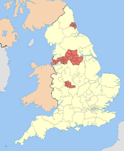
Walsall Council, formerly Walsall Metropolitan Borough Council was created in 1974 to administer the newly formed Metropolitan Borough of Walsall.
Walsall Council | |
|---|---|
| Type | |
| Type | Metropolitan district |
| Leadership | |
Mayor of Walsall | Cllr Paul Bott, Labour since 22 May 2019 |
Leader of the Council | |
Chief Executive | Dr Helen Paterson since 1 November 2017 |
| Structure | |
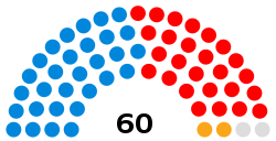
| Seats | 60 councillors |
 | |
Political groups |
|
Length of term | 4 years |
| Elections | |
| First past the post | |
Last election | 2 May 2019 |
Next election | 7 May 2020 |
| Meeting place | |
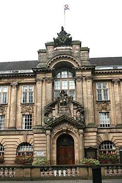 | |
| Walsall Council House | |
| Website | |
| walsall | |
The Metropolitan Borough of Walsall is based on an amalgamation of two former local government districts, Walsall County Borough and Aldridge-Brownhills Urban District. Both areas had previously seen major changes in 1966, with Walsall County Borough being expanded to cover areas formerly administered by the Municipal Boroughs of Bilston and Wednesbury, as well as the Urban Districts of Coseley, Darlaston, Willenhall and Wednesfield. However, in all cases only parts of those areas were transferred into the County Borough, with other areas being moved into different authorities.[2] Aldridge-Brownhills Urban District was created from the majority of the former Urban Districts of Aldridge and Brownhills, along with some smaller areas from other local authorities.
Walsall Metropolitan Borough Council was assessed by the Audit Commission in 2008 and judged to be "improving well" in providing services for local people. Overall the council was awarded "three star" status meaning it was "performing well" and "consistently above minimum requirements", similar to 46% of all local authorities.[3]
The council offices are located at the Civic Centre in the heart of Walsall. Elections to the council take place in three out of every four years, with one-third of the seats being contested at each election. Between its formation in 1974 and the 2003 election, the council varied between control by the Labour Party, and where no one party had an overall majority. From 2003 to the 2011 election the Conservative Party then held a majority of councillors.[4] However, in 2011 Labour made eight gains, including 5 from the Conservatives and as a result the council came under no overall control,[5] with the Conservatives continuing as a minority administration.[6]
During 2018, the number of councillors held by the Conservative group (30) exactly matches the number held by Labour, the Liberal Democrats and the Independents combined (30). Therefore the re-appointed mayor used his deciding vote in favour of the Conservatives.[7] As of January 2020 the Conservatives have an overall majority of councillors (32 of the 60 seats) and therefore run a majority administration.
Political composition
| Affiliation | Members[8] | ||||
|---|---|---|---|---|---|
| Current | |||||
| Conservative | 32 | ||||
| Labour | 26 | ||||
| Liberal Democrats | 2 | Total number of seats | 60 | ||
| Actual majority | Conservative | ||||
Electoral wards
The Metropolitan Borough Council has 60 local councillors representing 20 wards. The wards are:
| Ward name | Area (ha)/mi2 | Population (2001 census) |
Population density (people per hectare) | Ref. |
|---|---|---|---|---|
| Aldridge Central and South | 1,143 hectares (4.41 sq mi) | 12,267 | 10.73 | [9] |
| Aldridge North and Walsall Wood | 784 hectares (3.03 sq mi) | 12,874 | 16.43 | [10] |
| Bentley and Darlaston North | 439 hectares (1.69 sq mi) | 13,689 | 31.19 | [11] |
| Birchills Leamore | 413 hectares (1.59 sq mi) | 13,659 | 33.05 | [12] |
| Blakenall | 353 hectares (1.36 sq mi) | 11,950 | 33.86 | [13] |
| Bloxwich East | 369 hectares (1.42 sq mi) | 11,072 | 29.99 | [14] |
| Bloxwich West | 388 hectares (1.50 sq mi) | 14,816 | 38.15 | [15] |
| Brownhills | 724 hectares (2.80 sq mi) | 12,637 | 17.45 | [16] |
| Darlaston South | 334 hectares (1.29 sq mi) | 12,252 | 36.64 | [17] |
| Paddock | 546 hectares (2.11 sq mi) | 13,073 | 23.92 | [18] |
| Palfrey | 368 hectares (1.42 sq mi) | 14,596 | 39.71 | [19] |
| Pelsall | 499 hectares (1.93 sq mi) | 10,344 | 28.74 | [20] |
| Pheasey Park Farm | 758 hectares (2.93 sq mi) | 10,435 | 13.76 | [21] |
| Pleck | 338 hectares (1.31 sq mi) | 10,653 | 31.53 | [22] |
| Rushall-Shelfield | 577 hectares (2.23 sq mi) | 11,754 | 20.37 | [23] |
| Short Heath | 380 hectares (1.5 sq mi) | 11,435 | 30.05 | [24] |
| St. Matthew's | 353 hectares (1.36 sq mi) | 12,214 | 34.64 | [25] |
| Streetly | 750 hectares (2.9 sq mi) | 13,251 | 17.66 | [26] |
| Willenhall North | 235 hectares (0.91 sq mi) | 12,536 | 53.41 | [27] |
| Willenhall South | 481 hectares (1.86 sq mi) | 13,795 | 28.70 | [28] |
| Total | 10,396 hectares (40.14 sq mi) | 253,499 | 24.39 | [29] |
References
- "Conservatives re-take control of Walsall council". Express and Star. Retrieved 21 July 2018.
- "Relationships / unit history of WALSALL". A Vision of Britain. Retrieved 22 October 2009.
- "Walsall Metropolitban Borough Council comprehensive performance assessment (CPA) scorecard 2007". Audit Commission. 2008. Retrieved 22 October 2009.
- "Walsall local elections 2008". London: BBC Online. 2 May 2008. Retrieved 22 October 2009.
- "England council elections". BBC News Online. 10 May 2011. Retrieved 24 September 2011.
- "Walsall Council opts for minority administration". BBC News Online. 26 May 2011. Retrieved 24 September 2011.
- "Conservatives re-take control of Walsall council". Express and Star. Retrieved 21 July 2018.
- Express and Star published 3 May 2019
- "Area: Aldridge Central and South (Ward) Population Density (UV02)". Office for National Statistics. Retrieved 27 October 2009.
- "Area: Aldridge North and Walsall Wood (Ward) Population Density (UV02)". Office for National Statistics. Retrieved 27 October 2009.
- "Area: Bentley and Darlaston North (Ward) Population Density (UV02)". Office for National Statistics. Retrieved 27 October 2009.
- "Area: Birchills Leamore (Ward) Population Density (UV02)". Office for National Statistics. Retrieved 27 October 2009.
- "Area: Blakenall (Ward) Population Density (UV02)". Office for National Statistics. Retrieved 27 October 2009.
- "Area: Bloxwich East (Ward) Population Density (UV02)". Office for National Statistics. Retrieved 27 October 2009.
- "Area: Bloxwich East (Ward) Population Density (UV02)". Office for National Statistics. Retrieved 27 October 2009.
- "Area: Brownhills (Ward) Population Density (UV02)". Office for National Statistics. Retrieved 27 October 2009.
- "Area: Darlaston South (Ward) Population Density (UV02)". Office for National Statistics. Retrieved 27 October 2009.
- "Area: Paddock (Ward) Population Density (UV02)". Office for National Statistics. Retrieved 27 October 2009.
- "Area: Palfrey (Ward) Population Density (UV02)". Office for National Statistics. Retrieved 27 October 2009.
- "Area: Pelsall (Ward) Population Density (UV02)". Office for National Statistics. Retrieved 27 October 2009.
- "Area: Pheasey Park Farm (Ward) Population Density (UV02)". Office for National Statistics. Retrieved 27 October 2009.
- "Area: Pleck (Ward) Population Density (UV02)". Office for National Statistics. Retrieved 27 October 2009.
- "Area: Rushall – Shelfield (Ward) Population Density (UV02)". Office for National Statistics. Retrieved 27 October 2009.
- "Area: Short Heath (Ward) Population Density (UV02)". Office for National Statistics. Retrieved 27 October 2009.
- "Area: St. Matthew's (Ward) Population Density (UV02)". Office for National Statistics. Retrieved 27 October 2009.
- "Area: Streetly (Ward) Population Density (UV02)". Office for National Statistics. Retrieved 27 October 2009.
- "Area: Willenhall North (Ward) Population Density (UV02)". Office for National Statistics. Retrieved 27 October 2009.
- "Area: Willenhall South (Ward) Population Density (UV02)". Office for National Statistics. Retrieved 27 October 2009.
- "Area: Walsall (Local Authority) Population Density (UV02)". Office for National Statistics. Retrieved 27 October 2009.