Hopedale, Massachusetts
Hopedale is a town in Worcester County, Massachusetts, United States. The population was 5,911 at the 2010 census.
Hopedale, Massachusetts | |
|---|---|
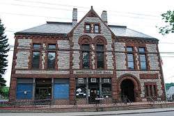 Town Hall | |
 Seal | |
 Hopedale Pond | |
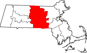
 Location in Worcester County and the state of Massachusetts. | |
| Coordinates: 42°07′50″N 71°32′30″W | |
| Country | United States |
| State | Massachusetts |
| County | Worcester |
| Settled | 1660 |
| Incorporated | 1886 |
| Government | |
| • Type | Open town meeting |
| Area | |
| • Total | 5.3 sq mi (13.8 km2) |
| • Land | 5.2 sq mi (13.4 km2) |
| • Water | 0.2 sq mi (0.4 km2) |
| Elevation | 280 ft (85 m) |
| Population (2010) | |
| • Total | 5,911 |
| • Density | 1,100/sq mi (430/km2) |
| Time zone | UTC-5 (Eastern) |
| • Summer (DST) | UTC-4 (Eastern) |
| ZIP code | 01747 |
| Area code(s) | 508 / 774 |
| FIPS code | 25-30945 |
| GNIS feature ID | 0618366 |
| Website | www.hopedale-ma.gov |
History

Hopedale was first settled in 1660. Benjamin Albee[1] built a mill on what is now the south end of Hopedale in 1664. A 64-square-mile (170 km2) area of the Blackstone Valley was incorporated as the town of Mendon. In 1780, Milford separated from Mendon. On August 26, 1841, Adin Ballou, along with the Practical Christians, gave Hopedale its name, within the town of Milford. Ballou and the Practical Christians established the Hopedale Community based on Christian and socialist ideologies in 1842. The utopian commune went bankrupt in 1856, and its assets were purchased by Ebenezer and George Draper, manufacturers of looms.[2] Various industries developed under the direction of the Draper brothers, including the Hopedale Machine Company and Hopedale Furnace Company. The town was officially incorporated in 1886 when it separated from Milford. George Draper designed, paid for, and constructed the town hall, which is constructed of granite from Milford and sandstone, and was dedicated in 1887.[2] The Unitarian church was another gift from the Drapers, and the Bancroft Memorial Library was a gift from a superintendent at the plant.[2] The marble sculpture outside the library was paid for by the Drapers and shipped from Rome in 1904.[2] In 1905, women were granted permission to swim at the town beach.
The family loom business continued to develop with subsequent generations, and at its peak, the Draper Corporation was the largest maker of textile looms in the United States. The company was acquired by Rockwell International in 1967. The Draper factory in Hopedale closed on August 29, 1980.[2]
Hopedale is included in the Blackstone River Valley National Heritage Corridor and is an historic mill village of national significance.
Geography
According to the United States Census Bureau, the town has a total area of 5.3 square miles (14 km2), of which 5.2 square miles (13 km2) is land and 0.2 square miles (0.52 km2), or 3.20%, is water. The largest body of water is Hopedale Pond, located not far from the town center.[3]
The central business district, known by Census Bureau as the Hopedale Census Designated Place (CDP) is located at 42°07′48″N 71°32′23″W (42.129872, -71.539594).[4]
According to the Census Bureau, the CDP has a total area of 4.5 km2 (1.7 mi2). 4.5 km2 (1.7 mi2) of it is land and 0.1 km2 (0.04 mi2) of it (1.15%) is water.
Adjacent towns
Hopedale is located in central Massachusetts, bordered by 4 towns:
Places adjacent to Hopedale, Massachusetts | ||||||||||
|---|---|---|---|---|---|---|---|---|---|---|
| ||||||||||
Demographics
Town
| Historical population | ||
|---|---|---|
| Year | Pop. | ±% |
| 1890 | 1,176 | — |
| 1900 | 2,087 | +77.5% |
| 1910 | 2,188 | +4.8% |
| 1920 | 2,777 | +26.9% |
| 1930 | 2,973 | +7.1% |
| 1940 | 3,113 | +4.7% |
| 1950 | 3,479 | +11.8% |
| 1960 | 3,987 | +14.6% |
| 1970 | 4,292 | +7.6% |
| 1980 | 3,905 | −9.0% |
| 1990 | 5,666 | +45.1% |
| 2000 | 5,907 | +4.3% |
| 2010 | 5,911 | +0.1% |
| * = population estimate. Source: United States Census records and Population Estimates Program data.[5][6][7][8][9][10][11] | ||
At the 2000 census there were 5,907 people, 2,240 households, and 1,572 families in the town. The population density was 1,145.8 people per square mile (442.0/km²). There were 2,289 housing units at an average density of 444.0 per square mile (171.3/km²). The racial makeup of the town was 97.23% White, 0.56% Black or African American, 0.02% Native American, 0.71% Asian, 0.51% from other races, and 0.68% from two or more races. Hispanic or Latino of any race were 1.17%.[12]
Of the 2,240 households 35.8% had children under the age of 18 living with them, 58.8% were married couples living together, 8.8% had a female householder with no husband present, and 29.8% were non-families. 25.9% of households were one person and 12.8% were one person aged 65 or older. The average household size was 2.58 and the average family size was 3.13.
The age distribution was 26.2% under the age of 18, 5.1% from 18 to 24, 30.8% from 25 to 44, 22.4% from 45 to 64, and 15.5% 65 or older. The median age was 39 years. For every 100 females, there were 90.9 males. For every 100 females age 18 and over, there were 87.7 males.
The median household income was $60,176 and the median family income was $68,571. Males had a median income of $47,380 versus $31,144 for females. The per capita income for the town was $24,791. About 2.9% of families and 4.0% of the population were below the poverty line, including 2.7% of those under age 18 and 6.5% of those age 65 or over.
CDP

As of the census[12] of 2000, there were 4,158 people, 1,616 households, and 1,082 families in the CDP. The population density was 933.4/km2 (2,411.4/mi2). There were 1,657 housing units at an average density of 372.0/km2 (961.0/mi2). The racial makeup of the CDP was 97.43% White, 0.51% Black or African American, 0.02% Native American, 0.67% Asian, 0.63% from other races, and 0.75% from two or more races. Hispanic or Latino of any race were 1.30% of the population.
Of the 1,616 households 34.5% had children under the age of 18 living with them, 55.3% were married couples living together, 9.3% had a female householder with no husband present, and 33.0% were non-families. 29.0% of households were one person and 14.4% were one person aged 65 or older. The average household size was 2.52 and the average family size was 3.15.
The age distribution was 26.6% under the age of 18, 5.2% from 18 to 24, 30.7% from 25 to 44, 22.4% from 45 to 64, and 15.0% 65 or older. The median age was 39 years. For every 100 females, there were 91.3 males. For every 100 females age 18 and over, there were 86.0 males.
The median household income was $58,750 and the median family income was $67,417. Males had a median income of $45,694 versus $29,740 for females. The per capita income for the CDP was $24,088. About 3.4% of families and 4.7% of the population were below the poverty line, including 3.2% of those under age 18 and 5.8% of those age 65 or over.
| County-level state agency heads | |
|---|---|
| Clerk of Courts: | Dennis P. McManus (D) |
| District Attorney: | Joe Early Jr. (D) |
| Register of Deeds: | Katie Toomey (D) |
| Register of Probate: | Stephanie Fattman (R) |
| County Sheriff: | Lew Evangelidis (R) |
| State government | |
| State Representative(s): | Brian W. Murray (D) |
| State Senator(s): | Ryan Fattman (R) |
| Governor's Councilor(s): | Jen Caissie (R) |
| Federal government | |
| U.S. Representative(s): | Joseph P. Kennedy III (D-4th District), |
| U.S. Senators: | Elizabeth Warren (D), Ed Markey (D) |
Notable people
- Adin Ballou, noted 19th-century pacifist, socialist, and abolitionist
- Dick Bresciani, Boston Red Sox executive
- Brendan Burke, Major League Soccer coach
- Eben Sumner Draper, 44th Governor of Massachusetts
- Eben S. Draper Jr., Massachusetts state representative
- Jason Myles Goss, singer/songwriter
- Dana Gould, comedian
- Kevin Nee, professional strongman athlete
- Joe Perry of Aerosmith[13]
Public schools
Students in grades K–6 go to the Memorial School. Hopedale Junior Senior High School is for grades 7–12.
Places of Worship
There are currently three houses of worship in Hopedale.
- Sacred Heart of Jesus Catholic Church
- Hopedale Unitarian Parish
- Union Evangelical Church
See also
References
- "A History of Hopedale | Town of Hopedale MA". www.hopedale-ma.gov. Retrieved 2019-04-20.
- A small town's big eyesore / Hopedale officials again seek to develop vacant factory and transform the community
- http://www.mass.gov/eea/docs/dfg/dfw/habitat/maps-ponds/dfwhope.pdf
- "US Gazetteer files: 2010, 2000, and 1990". United States Census Bureau. 2011-02-12. Retrieved 2011-04-23.
- "TOTAL POPULATION (P1), 2010 Census Summary File 1, All County Subdivisions within Massachusetts". United States Census Bureau. Archived from the original on February 12, 2020. Retrieved September 13, 2011.
- "Massachusetts by Place and County Subdivision - GCT-T1. Population Estimates". United States Census Bureau. Archived from the original on November 3, 2011. Retrieved July 12, 2011.
- "1990 Census of Population, General Population Characteristics: Massachusetts" (PDF). US Census Bureau. December 1990. Table 76: General Characteristics of Persons, Households, and Families: 1990. 1990 CP-1-23. Archived from the original (PDF) on December 7, 2013. Retrieved July 12, 2011.
- "1980 Census of the Population, Number of Inhabitants: Massachusetts" (PDF). US Census Bureau. December 1981. Table 4. Populations of County Subdivisions: 1960 to 1980. PC80-1-A23. Retrieved July 12, 2011.
- "1950 Census of Population" (PDF). 1: Number of Inhabitants. Bureau of the Census. 1952. Section 6, Pages 21-10 and 21-11, Massachusetts Table 6. Population of Counties by Minor Civil Divisions: 1930 to 1950. Retrieved July 12, 2011. Cite journal requires
|journal=(help) - "1920 Census of Population" (PDF). Bureau of the Census. Number of Inhabitants, by Counties and Minor Civil Divisions. Pages 21-5 through 21-7. Massachusetts Table 2. Population of Counties by Minor Civil Divisions: 1920, 1910, and 1920. Retrieved July 12, 2011.
- "1890 Census of the Population" (PDF). Department of the Interior, Census Office. Pages 179 through 182. Massachusetts Table 5. Population of States and Territories by Minor Civil Divisions: 1880 and 1890. Retrieved July 12, 2011.
- "U.S. Census website". United States Census Bureau. Retrieved 2008-01-31.
- Zachary Comeau (October 25, 2014). "Aerosmith's Joe Perry honors the musical influence of a Milford friend". Milford Daily News. Retrieved May 23, 2017.
Further reading
- Spann, Edward K. (31 March 1992). Hopedale: From Commune to Company Town, 1840-1920. Ohio State University Press. ISBN 9780814205754.
External links
| Wikimedia Commons has media related to Hopedale, Massachusetts. |
| Authority control |
|
|---|