Interstate 290 (Massachusetts)
Interstate 290 (I-290) is an auxiliary Interstate Highway in the U.S. state of Massachusetts, maintained by the Massachusetts Department of Transportation (MassDOT). Spanning approximately 20 miles (32 km), it is signed as an east-west spur route of I-90 (the Massachusetts Turnpike) in Central Massachusetts. The route begins in Auburn at I-90 as a northward continuation of I-395. It follows L-shaped route, the nominally western half of the route runs north into the city of Worcester, and upon leaving the city, turns to the east to its eastern terminus at I-495 in Marlborough. Past I-495, the road continues as an unnumbered 1-mile connector to the town of Hudson.
| ||||
|---|---|---|---|---|
%26groups%3D_e43811075ac105d4146c6e3df1f0a5a9920e8529.svg)
I-290 highlighted in red | ||||
| Route information | ||||
| Auxiliary route of I‑90 | ||||
| Maintained by MassDOT | ||||
| Length | 20.16 mi[1] (32.44 km) | |||
| Existed | 1970–present | |||
| Major junctions | ||||
| West end | ||||
| East end | ||||
| Location | ||||
| Counties | Worcester, Middlesex | |||
| Highway system | ||||
| ||||

Route description
Exit numbers on I-290 are a continuation of I-395 exit numbers. I-290 begins as the continuation of I-395 in Auburn with exits to I-90, Route 12, and the Auburn Mall. 290 continues north through Worcester into Downtown, where Route 146 and I-190 split off. After 146, I-290 has exits for Route 122A, Route 122, downtown, and Route 9. After 190, 290 presumes east to a junction with Route 70, then continues over Quinsigamond Lake into Shrewsbury, where it goes northeast. 290 has a junction with Route 140 and starts east into Boylston and Northborough, where it travels northeast again. 290 enters Marlborough with an exit for Solomon Pond Mall and has its final junction with 495, where it terminates shortly after on the Route 85 Connector.
History
Originally, I-290 was to rejoin I-90 in Westborough, roughly where I-495 sits now. However, this route would have run through the town centers of Shrewsbury and Northborough. Additionally, I-290 was intended to be extended past I-495 to I-95/Route 128 in Waltham, but this was canceled under pressure from towns along the planned route. A brief two-lane connector heads to Route 85 as a result of this aborted plan. The interchange with I-495 was originally supposed to be a cloverleaf, but after the plan was canceled, it was modified with a flyover ramp onto 495-northbound. In 2004, the former exit 12 (Route 146 south) was closed when the Route 146 freeway was under construction between the Mass Pike and I-290. It was completed in 2007. The current exit 12 replaces the former one.
Future
Milepost-based exit numbering
While Massachusetts has used sequential exit numbers since 1964,[2] the 2009 edition of the Manual on Uniform Traffic Control Devices required that all U.S. states submit plans to transition to milepost-based exit numbering by 2012.[3] All interchanges were to be renumbered to milepost-based numbers under a project scheduled to start in 2016.[4] However, this project was indefinitely postponed until November 18, 2019, when MassDOT confirmed that the exit renumbering project will begin, and "dual" mile markers with I-395 mileage will be installed, in late summer 2020.[5] The department stated that it would consider re-designating I-290 as an extension of I-395 if the exit numbering project and dual mile markers are well-received by motorists.[6]
Exit list
MassDOT is scheduled to replace sequential exit numbers with milepost-based exit numbers beginning in summer 2020.[7]
| County | Location[8] | mi[8] | km | Old exit[9] | New exit[10] | Destinations | Notes |
|---|---|---|---|---|---|---|---|
| Worcester | Auburn | 0.000 | 0.000 | — | — | Exit numbers continue from I-395 | |
| 0.347 | 0.558 | 7 | 12A | Eastbound exit signed as Exit 12 to Route 12 south; westbound exit to Route 12 north; exit 10 on I-90 / Mass Pike | |||
| 0.070 | 0.113 | 8 | 12B | Westbound exit only | |||
| 0.930 | 1.497 | 9 | 13 | Swanson Road – Auburn | Eastbound exit and westbound entrance (from Vine Street) | ||
| 1.700 | 2.736 | Auburn Street – Auburn | Westbound exit and eastbound entrance | ||||
| Worcester | 3.358 | 5.404 | 10 | 14 | Westbound exit and eastbound entrance | ||
| 3.565 | 5.737 | 11 | 15 | College Square / Federal Square / Southbridge Street | |||
| 4.611 | 7.421 | 12 | 16 | Westbound exit and eastbound entrance; former configuration had complete access via a rotary. | |||
| 5.265 | 8.473 | 13 | 17 | ||||
| 5.638 | 9.073 | 14 | 18 | No westbound entrance | |||
| 5.810 | 9.350 | 15 | 19 | Shrewsbury Street | Eastbound exit and westbound entrance | ||
| 6.137 | 9.877 | 16 | 20 | MLK Jr. Boulevard – Downtown Worcester | Serves Union Station, Saint Vincent Hospital, DCU Center | ||
| 6.572 | 10.577 | 17 | 21 | Eastbound exit and westbound entrance | |||
| 6.980 | 11.233 | 18 | 21 | Westbound exit and eastbound entrance | |||
| 7.377 | 11.872 | 19 | 22 | Southern terminus of I-190; eastbound exit is combined with exit 20 | |||
| 7.377 | 11.872 | 20 | 23 | Eastbound exit and westbound entrance; combined exit ramp with exit 19 | |||
| 8.421 | 13.552 | Westbound exit and eastbound entrance | |||||
| 9.641 | 15.516 | 21 | 24 | Plantation Street – Worcester | Eastbound exit and westbound entrance | ||
| Shrewsbury | 10.173 | 16.372 | 22 | 25 | Main Street – Shrewsbury, Worcester | ||
| 12.685 | 20.415 | 23 | 26 | Signed as exits 26A (south) and 26B (north) | |||
| Northborough | 14.855 | 23.907 | 24 | 27 | Church Street – Northborough, Boylston | ||
| 17.913 | 28.828 | 25A | 30A | Hudson Street – Northborough | |||
| 17.925 | 28.847 | 25B | 30B | Solomon Pond Mall Road – Berlin | To Solomon Pond Mall; exit partially located in Marlboro | ||
| Middlesex | Marlborough | 20.000 | 32.187 | 26 | 32 | Signed as exits 32A (south) and 32B (north); exits 25A-B on I-495 | |
| 20.16 | 32.44 | — | — | Access via 0.9-mile (1.4 km) Route 85 Connector[11] | |||
1.000 mi = 1.609 km; 1.000 km = 0.621 mi
| |||||||
Gallery
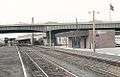 The I-290 viaduct at Worcester station in 1976
 The I-290 Route 146 junction seen under construction as well as Downtown Worcester from above looking north
 Orson the bear, the mascot of Polar Beverages, is a prominent landmark visible from I-290 in Worcester
References
- "Route Log- Auxiliary Routes of the Eisenhower National System of Interstate and Defense Highways - Table 2". Federal Highway Administration. Retrieved 5 October 2014.
- Clauss, Kyle Scott (April 8, 2016). "Many Massachusetts Highway Exit Numbers Could Soon Change". Boston Magazine. Retrieved June 28, 2018.
- Thompson, Elaine (March 19, 2016). "Watchdog Report: No signs yet from state on exit-conversion launch". Telegram & Gazette. Worcester, MA. Retrieved June 28, 2018.
- Commonwealth of Massachusetts (2015). "COMMBUYS - Bid Solicitation FAP# HSIP-002S(874) Exit Signage Conversion to Milepost-Based Numbering System along Various Interstates, Routes and the Lowell Connector". Retrieved January 5, 2016.
- Robert H. Malme (2017). "Massachusetts Interstate Highways Exit Lists". Retrieved January 18, 2017.
- Malme, Robert H. (December 14, 2019). "I-290 MA Exit List". Malme Roads. Retrieved May 13, 2020.
- "Milepost-based Exit Renumbering" (PDF). Massachusetts Department of Transportation. December 5, 2019. Retrieved December 5, 2019.
- "MassDOT Route Log Application". Massachusetts Department of Transportation. Retrieved November 21, 2019.
- "Major highway routes and exits". Massachusetts Department of Transportation. Archived from the original on October 15, 2019. Retrieved November 21, 2019.
- "I-395 & I-290 Renumbering" (PDF). Massachusetts Department of Transportation. December 5, 2019. Retrieved December 5, 2019.
- Google (August 10, 2015). "Route 85 Connector" (Map). Google Maps. Google. Retrieved August 10, 2015.
External links
| Wikimedia Commons has media related to Interstate 290 (Massachusetts). |