Interstate 190 (Massachusetts)
Interstate 190 (I-190) is an auxiliary Interstate Highway in the U.S. state of Massachusetts, maintained by the Massachusetts Department of Transportation (MassDOT). Spanning approximately 19 miles (31 km) along a south–north axis, it is a spur route of I-90 (the Massachusetts Turnpike) in Central Massachusetts. However, its southern terminus exists at its split from I-290 in Worcester, which itself splits from the turnpike in Auburn. Its northern terminus lays at an interchange with Route 2 in Leominster.
| ||||
|---|---|---|---|---|
%26groups%3D_c5e3f77b0681af4e3eb145225c7a244a2067c71e.svg)
I-190 highlighted in red | ||||
| Route information | ||||
| Auxiliary route of I‑90 | ||||
| Maintained by MassDOT | ||||
| Length | 19.26 mi[1] (31.00 km) | |||
| Existed | 1983–present | |||
| Major junctions | ||||
| South end | ||||
| North end | ||||
| Location | ||||
| Counties | Worcester | |||
| Highway system | ||||
| ||||

Route description
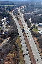
I-190 begins at a southern terminus with I-290 in Worcester. Near the Greendale Mall, there is an interchange with Route 12 before the highway passes along the eastern shore of Indian Lake and continues through the city of Worcester. In West Boylston, I-190 has another interchange with Route 12 before turning northwest into Holden and then to the north and crossing the Quinapoxet River. The freeway curves to the northeast reentering West Boylston and enters a more rural area. I-190 intersects Route 140 and Route 12 another time in Sterling. In Lancaster, I-190 has an exit for Route 117. North of Johnny Appleseed State Park and Lancaster State Forest, I-190 merges and terminates at Route 2 and Mechanic Street in the city of Leominster.[2]
A portion of the highway was built with extra-wide shoulders, which are painted green, to prevent runoff from contaminating the nearby Wachusett Reservoir.[3]
Exit list
All interchanges were to be renumbered to mileage-based numbers under a project scheduled to start in 2016.[4] However, this project was indefinitely postponed until November 18, 2019, when the MassDOT confirmed that beginning in late summer 2020 the exit renumbering project will begin.[5] The entire route is in Worcester County. [6]
| Location[6] | mi[6] | km | Old exit | New exit[7] | Destinations[8] | Notes | |
|---|---|---|---|---|---|---|---|
| Worcester | 0.000 | 0.000 | — | — | Exit 19 on I-290 (scheduled to be exit 22[9]), southern terminus | ||
| 1.111 | 1.788 | 1 | 1 | ||||
| 2.346 | 3.776 | 2 | 2 | (Frontage Road) Ararat Street – Holden, Greendale | |||
| 3.542 | 5.700 | 3 | 3 | West Mountain Street – Holden, Boylston | Southbound exit and northbound entrance | ||
| West Boylston | 3.980 | 6.405 | 4 | 4 | Exit connector enters Worcester before reaching Route 12 | ||
| Sterling | 9.272 | 14.922 | 5 | 9 | Southern portion of the exit is in W. Boylston | ||
| 14.123 | 22.729 | 6 | 14 | ||||
| Lancaster | 16.894 | 27.188 | 7 | 17 | Exit is partially in Leominster | ||
| Leominster | 19.122 | 30.774 | 8B | 19A | Northbound exit and southbound entrance | ||
| 19.950 | 32.106 | 8A | 19B | Northbound exit and southbound entrance; northern terminus | |||
| 19.37 | 31.17 | 8 | 19 | Mechanic Street (Nashua Street) – Leominster | Southbound exit and northbound entrance | ||
| 1.000 mi = 1.609 km; 1.000 km = 0.621 mi | |||||||
References
- Staff (October 31, 2002). "Table 2: Auxiliary Routes of the Eisenhower National System of Interstate and Defense Highways". Route Log and Finder List. Federal Highway Administration.
- Google (December 21, 2013). "I-190 Massachusetts" (Map). Google Maps. Google. Retrieved December 21, 2013.
- "Ask the Globe". The Boston Globe. June 21, 1997. Archived from the original on December 4, 2013. Retrieved December 2, 2013.
Massachusetts Highway spokeswoman Julie Vitek says those paved shoulders and similar ones in West Boylston near the Wachusett Reservoir were built in the 1970s to direct collected melted snow and salt into a Massachusetts highway closed well system, independent from drinking water supplies.
- Commonwealth of Massachusetts (2015). "COMMBUYS - Bid Solicitation FAP# HSIP-002S(874) Exit Signage Conversion to Milepost-Based Numbering System along Various Interstates, Routes and the Lowell Connector". Retrieved January 5, 2016.
- "Milepost-based Exit Renumbering" (PDF). Massachusetts Department of Transportation. December 5, 2019. Retrieved December 5, 2019.
- MassDOT Planning Division. "Massachusetts Route Log Application". Massachusetts Department of Transportation. Archived from the original on August 26, 2014. Retrieved August 21, 2014.
- "I-190 Renumbering" (PDF). Massachusetts Department of Transportation. December 5, 2019. Retrieved December 5, 2019.
- "Exit Numbers and Names: Route I-190 (Worcester to Leominster)". Massachusetts Department of Transportation. Archived from the original on August 26, 2014. Retrieved August 21, 2014.
- "I-395 & I-290 Renumbering" (PDF). Massachusetts Department of Transportation. December 5, 2019. Retrieved December 5, 2019.
External links
| Wikimedia Commons has media related to Interstate 190. |
- History of I-190 MA at Boston Roads