Maine State Route 4
State Route 4 (abbreviated SR 4 or ME 4) is a 168.85-mile (271.74 km) long state highway located in southwestern Maine. Its southern terminus is at the New Hampshire border in South Berwick, where it connects to New Hampshire Route 4. Its northern terminus is at Haines Landing on Mooselookmeguntic Lake in Rangeley.
| ||||
|---|---|---|---|---|
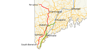 Route of SR 4 highlighted in red | ||||
| Route information | ||||
| Maintained by MaineDOT | ||||
| Length | 168.85 mi[1] (271.74 km) | |||
| Existed | 1931–present | |||
| Major junctions | ||||
| South end | ||||
| North end | Haines Landing in Rangeley | |||
| Location | ||||
| Counties | York, Cumberland, Androscoggin, Franklin | |||
| Highway system | ||||
| ||||

Major cities and towns along the length of SR 4 include Sanford, Gorham, Windham, Auburn and Farmington.
Approximately one-third of the overall length of SR 4 is overlapped by U.S. Route 202 (US 202).
Route description
SR 4 begins at the New Hampshire state line, where the roadway continues south as NH 4 towards Dover. From South Berwick, SR 4 runs in a northeasterly direction through the town of North Berwick, bypassing the center of Sanford to the east, and intersects US 202 in Alfred. SR 4 runs concurrently with US 202 for 56.0 miles (90.1 km) to the city of Auburn via the towns of Gorham, Windham and Gray.
North of Auburn, SR 4 continues northward, staying near the west bank of the Androscoggin River, through the town of Turner, to Livermore, where it crosses the river to Livermore Falls. SR 4 continues to an intersection with US 2 in Wilton, and runs concurrently with it for 7.8 miles (12.6 km) to Farmington.
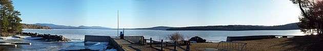
SR 4 follows the Sandy River north of Farmington, through the towns of Strong and Phillips, and west to the river's source near Saddleback Mountain. The road turns north to Rangeley, where it turns west and runs concurrently with SR 16 at Oquossoc. SR 4 meets SR 17, then continues northwest to its terminus at Haines Landing on the shore of Mooselookmeguntic Lake.
History
SR 4 was designated in 1931 as a continuation of US 4 in New Hampshire, hence its number. Although US 4 does come close to the Maine border, the intended connection never came to fruition, as US 4 was routed south of Dover to terminate in Portsmouth. Instead, an indirect connection exists, facilitated by NH 4, NH 9, and NH 16 (the Spaulding Turnpike).
As first designated in 1931, SR 4 extended from its current southern terminus in South Berwick all the way to the Canada–US border. By 1937, most of the routes that are currently cosigned with it had been designated, most notably US 202. In 1946, SR 4 was truncated to its southern intersection with SR 16 in Rangeley, but was later re-extended along SR 16 to terminate at its current end at Haines Landing in 1951 (the road between SR 16 and Haines Landing had previously been designated SR 144). Most of former SR 4 between SR 16 and the Canada–US border is now part of SR 27.
Junction list
| County | Location[1] | mi[1] | km | Destinations | Notes |
|---|---|---|---|---|---|
| York | South Berwick | 0.00 | 0.00 | Continuation beyond New Hampshire state line | |
| 0.34 | 0.55 | Southern terminus of SR 236 concurrency | |||
| 0.54 | 0.87 | Northern terminus of SR 236 concurrency | |||
| Berwick | 1.32– 4.21 | 2.12– 6.78 | No major junctions | ||
| North Berwick | 6.51 | 10.48 | Southern terminus of SR 9 concurrency | ||
| 6.98 | 11.23 | Northern terminus of SR 9 concurrency | |||
| Sanford | 14.49 | 23.32 | Rotary; southern terminus of SR 4A (southern segment) | ||
| Alfred | 18.97 | 30.53 | Southern terminus of US 202 concurrency; northern terminus of SR 4A (southern segment); western terminus of SR 111 | ||
| Waterboro | 26.89 | 43.28 | Southern terminus of wrong-way concurrency with SR 5 | ||
| Lyman | 28.73 | 46.24 | Northern terminus of wrong-way concurrency with SR 5 | ||
| Hollis | 32.15 | 51.74 | Southern terminus of SR 4A (northern segment) | ||
| 32.63 | 52.51 | Southern terminus of wrong-way concurrency with SR 117 | |||
| Buxton | 34.36 | 55.30 | Northern terminus of wrong-way concurrency with SR 117 | ||
| 35.43 | 57.02 | ||||
| 36.30 | 58.42 | Northern terminus of SR 4A (northern segment) | |||
| 38.03 | 61.20 | ||||
| Cumberland | Gorham | 41.49 | 66.77 | Rotary | |
| 42.37 | 68.19 | Southern terminus of SR 25 concurrency | |||
| 42.57 | 68.51 | ||||
| 43.03 | 69.25 | Northern terminus of SR 25 concurrency | |||
| 46.29 | 74.50 | Rotary | |||
| Windham | 51.65 | 83.12 | Rotary | ||
| Gray | 55.38 | 89.13 | Southern terminus of SR 115 concurrency | ||
| 58.73 | 94.52 | Southern terminus of wrong-way concurrency with SR 26A | |||
| 58.73– 59.00 | 94.52– 94.95 | Exit 63 on Maine Turnpike | |||
| 59.17 | 95.22 | Southern terminus of SR 26A; northern terminus of SR 115 concurrency; southern terminus of SR 26 / SR 100 concurrency | |||
| 59.22 | 95.31 | Northern terminus of SR 26 concurrency | |||
| New Gloucester | 66.79 | 107.49 | Northern terminus of SR 231 | ||
| Androscoggin | Auburn | 69.44 | 111.75 | Eastern terminus of SR 122 | |
| 70.45 | 113.38 | Exit 75 on Maine Turnpike | |||
| 74.49 | 119.88 | Southern terminus of SR 11 concurrency; northern terminus of SR 121 | |||
| 75.20 | 121.02 | Northern terminus of US 202 / SR 11 / SR 100 concurrency To | |||
| 76.87 | 123.71 | Interchange | |||
| Turner | 86.67 | 139.48 | |||
| 92.94 | 149.57 | ||||
| Livermore | 95.86 | 154.27 | Southern terminus of SR 108 concurrency | ||
| 96.90 | 155.95 | Northern terminus of SR 108 concurrency | |||
| Livermore Falls | 103.76 | 166.99 | Southern terminus of SR 17 concurrency | ||
| Franklin | Jay | 106.34 | 171.14 | Northern terminus of SR 140 | |
| 109.53 | 176.27 | Northern terminus of SR 17 concurrency | |||
| Wilton | 112.00 | 180.25 | Southern terminus of US 2 concurrency | ||
| 112.85 | 181.61 | ||||
| Farmington | 116.84 | 188.04 | Northern terminus of SR 133 | ||
| 119.62 | 192.51 | Southern terminus of SR 43 concurrency | |||
| 119.77 | 192.75 | Northern terminus of US 2 concurrency; southern terminus of SR 27 concurrency | |||
| 120.41 | 193.78 | Northern terminus of SR 43 concurrency | |||
| 122.86 | 197.72 | Northern terminus of SR 27 concurrency | |||
| 123.18 | 198.24 | Southern terminus of SR 149 | |||
| Strong | 131.37 | 211.42 | Southern terminus of SR 145 | ||
| Avon | 132.77– 138.39 | 213.67– 222.72 | No major junctions | ||
| Phillips | 138.91 | 223.55 | Southern terminus of wrong-way concurrency with SR 142 | ||
| 140.21 | 225.65 | Northern terminus of wrong-way concurrency with SR 142 | |||
| Madrid Township | 144.99– 148.44 | 233.34– 238.89 | No major junctions | ||
| Township E | 148.44– 149.09 | 238.89– 239.94 | No major junctions | ||
| Sandy River Plantation | 149.09– 157.99 | 239.94– 254.26 | No major junctions | ||
| Rangeley Plantation | 157.99– 158.51 | 254.26– 255.10 | No major junctions | ||
| Rangeley | 160.52 | 258.33 | Southern terminus of SR 16 concurrency | ||
| 167.01 | 268.78 | Northern terminus of SR 16 concurrency | |||
| 167.34 | 269.31 | Western terminus of SR 17 | |||
| 168.85 | 271.74 | Haines Landing - Mooselookmeguntic Lake | Dead end; northern terminus | ||
1.000 mi = 1.609 km; 1.000 km = 0.621 mi
| |||||
Auxiliary routes
State Route 4A (abbreviated SR 4A) is the designation for two separate, but closely located, auxiliary routes of SR 4. While not directly connected to one another, they are linked by a 4.15-mile (6.68 km) stretch of US 202 and SR 4 between Hollis and Buxton.
Southern segment
| |
|---|---|
| Location | Sanford |
| Length | 6.72 mi[1] (10.81 km) |
| Existed | 1941–present |
The southern segment of SR 4A runs between the towns of Sanford and Alfred. It is concurrent over its entire 6.5-mile (10.5 km) length, running on sections of SR 109 and US 202. SR 4A is a service route for downtown Sanford, which SR 4 bypasses to the east.
This segment of SR 4A begins at an intersection with SR 4 and SR 109 south of downtown. SR 4A and SR 109 run concurrently northwest into the center of town, where they intersect with US 202 and SR 11 at Lebanon and Winter Streets. SR 109 continues straight to join SR 11, while SR 4A turns onto Winter Street to join US 202. US 202 and SR 4A run concurrently to the northeast, crossing SR 224 (another bypass of downtown Sanford), then cross into Alfred where they intersect with SR 4 and SR 111. SR 4A ends at this intersection, US 202 turns north to join SR 4 and SR 111 begins to the east.
- Junction list
The entire route is in York County. [1]
| Location[1] | mi[1] | km | Destinations | Notes | |
|---|---|---|---|---|---|
| Sanford | 0.00 | 0.00 | Rotary; southern terminus of SR 4A | ||
| 2.81 | 4.52 | Northern terminus of SR 109 concurrency; southern terminus of US 202 concurrency | |||
| 4.32 | 6.95 | Eastern terminus of SR 224 | |||
| Alfred | 6.72 | 10.81 | Northern terminus of SR 4A; western terminus of SR 111 | ||
1.000 mi = 1.609 km; 1.000 km = 0.621 mi
| |||||
Northern segment
| |
|---|---|
| Location | Hollis–Buxton |
| Length | 3.78 mi[1] (6.08 km) |
| Existed | 1938–present |
The northern segment of SR 4A runs for 4.0 miles (6.4 km) between Hollis and Buxton and is a northern alternate to US 202 / SR 4. Like the southern segment, this segment is signed north-south, but is oriented nearly due west to east.
This segment begins at an intersection between US 202 / SR 4 and SR 35 in Hollis. SR 4A and SR 35 share a brief concurrency before SR 4A splits off to the east, crossing SR 117 in the process. The highway continues to the east into the town of Buxton. SR 4A then crosses SR 112 before terminating at US 202 / SR 4.
- Junction list
Mileposts on this section of SR 4A continue from the southern segment, omitting the connecting section of US 202 / SR 4.
The entire route is in York County. [1]
| Location[1] | mi[1] | km | Destinations | Notes | |
|---|---|---|---|---|---|
| Hollis | 6.72 | 10.81 | Southern terminus | ||
| 6.94 | 11.17 | Northern terminus of SR 35 concurrency | |||
| 7.09 | 11.41 | ||||
| Buxton | 9.74 | 15.68 | |||
| 10.50 | 16.90 | Northern terminus | |||
1.000 mi = 1.609 km; 1.000 km = 0.621 mi
| |||||
References
- "MaineDOT Public Map Viewer". Maine Department of Transportation. Retrieved June 10, 2017.
External links
| Wikimedia Commons has media related to Maine State Route 4. |