Maine State Route 117
State Route 117 (SR 117) is part of Maine's system of numbered state highways, running from SR 112 in Saco to SR 219 in Turner.
| ||||
|---|---|---|---|---|
 | ||||
| Route information | ||||
| Maintained by MaineDOT | ||||
| Length | 87.64 mi[1] (141.04 km) | |||
| Existed | 1925, 1951 (current alignment)–present | |||
| Major junctions | ||||
| South end | ||||
| North end | ||||
| Location | ||||
| Counties | York, Cumberland, Oxford, Androscoggin | |||
| Highway system | ||||
| ||||

Route description
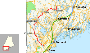
SR 117 begins at SR 112 in Saco. It travels north through Buxton and Hollis, running concurrently with U.S. Route 202 (US 202) and SR 4 for 2 miles (3.2 km). It turns off and continues through the towns of Hollis, Limington, and Waterboro. From there, SR 117 travels concurrently with SR 25 for 3 miles (4.8 km), entering Cornish, then turns off. It is shortly joined by SR 5. It runs concurrently with only SR 5 for 2 miles (3.2 km) into Baldwin, and with SR 5 and SR 113 for 5 miles (8.0 km) into Hiram. In Hiram, SR 117 leaves SR 113 and SR 5, and enters Denmark. SR 117 continues on into Bridgton where it eventually intersects US 302. SR 117 runs concurrently with US 302 for 2 miles (3.2 km). It then continues on into the towns of Harrison and Norway. It runs concurrently with SR 118 for 2 miles (3.2 km) until its end at the intersection of SR 26. It then runs concurrently with SR 26 for 1 mile (1.6 km) into Paris. From there, it continues into Buckfield and then Turner, where it reaches it northern terminus at SR 219.
Junction list
| County | Location | mi | km | Destinations | Notes |
|---|---|---|---|---|---|
| York | Saco | 0.0 | 0.0 | ||
| Buxton | 2.4 | 3.9 | East end of US 202/SR 4 concurrency | ||
| Hollis | 4.1 | 6.6 | West end of US 202/SR 4 concurrency | ||
| 4.4 | 7.1 | ||||
| 4.5 | 7.2 | ||||
| Limington | 16.0 | 25.7 | |||
| 20.8 | 33.5 | East end of SR 25 concurrency | |||
| Cornish | 23.3 | 37.5 | |||
| 23.4 | 37.7 | South end of SR 5 concurrency | |||
| Cumberland | Baldwin | 24.8 | 39.9 | South end of SR 113 concurrency | |
| Oxford | Hiram | 29.9 | 48.1 | South end of SR 5/SR 113 concurrency | |
| Denmark | 37.1 | 59.7 | Northern terminus of SR 160 | ||
| Cumberland | Bridgton | 43.7 | 70.3 | Northern terminus of SR 107 | |
| 44.6 | 71.8 | South end of US 302 concurrency | |||
| 46.1 | 74.2 | North end of US 302 concurrency | |||
| 49.1 | 79.0 | Southern terminus of SR 37 | |||
| Harrison | 50.6 | 81.4 | North end of SR 35 concurrency | ||
| 50.8 | 81.8 | South end of SR 35 concurrency | |||
| Oxford | Norway | 61.3 | 98.7 | West end of SR 118 concurrency | |
| 63.3 | 101.9 | East end of SR 118 concurrency; eastern terminus of SR 118 | |||
| 63.7 | 102.5 | South end of SR 26 concurrency | |||
| Paris | 64.9 | 104.4 | North end of SR 26/SR 119 concurrencies; northern terminus of SR 119 | ||
| 65.3 | 105.1 | South end of SR 119 concurrency | |||
| Buckfield | 74.9 | 120.5 | Southern terminus of SR 140 | ||
| 77.6 | 124.9 | Northern terminus of SR 124 | |||
| Androscoggin | Turner | 81.5 | 131.2 | ||
| 88.16 | 141.88 | ||||
1.000 mi = 1.609 km; 1.000 km = 0.621 mi
| |||||
References
- Maine DOT Map Viewer (Map). Maine Office of GIS. Retrieved October 20, 2017.