Maine State Route 196
State Route 196 (SR 196) is a state highway in the U.S. state of Maine. It connects Lewiston to Brunswick, following the Androscoggin River valley.
| ||||
|---|---|---|---|---|
 | ||||
| Route information | ||||
| Maintained by MaineDOT | ||||
| Length | 19.41 mi[1] (31.24 km) | |||
| Existed | 1925–present | |||
| Major junctions | ||||
| West end | ||||
| East end | ||||
| Location | ||||
| Counties | Androscoggin, Sagadahoc, Cumberland | |||
| Highway system | ||||
| ||||

Route description
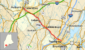
ME 196 begins at a junction with U.S. Route 1, which is an alignment change from U.S. 201. The alignment is called the Brunswick-Topsham bypass and the first leg of the route is a limited access two lane undivided highway. Signs on I-295 refer to this portion as the Coastal Connector to avoid using the term bypass, as it was feared doing so would drive too much traffic from Downtown Brunswick businesses. It eventually reverts to a surface street (and major arterial) through Topsham but does provide a more direct route for travelers on U.S. 1 to access I-295 without having to go through Brunswick. It then intersects with U.S. 201 in Topsham (Main St.) and finally crosses I-295 where it has an interchange. It continues north and passes through Lisbon Falls, Lisbon, and then passes under the Maine Turnpike (I-95) and then enters the city of Lewiston. It is known as Lisbon St. in Lewiston and for its last segment before it ends is a divided 4 lane city street with westbound traffic on Lisbon St. and eastbound traffic on Canal St. It ends at Main St. which is multiplexed at this point as U.S. 202, ME 11, and ME 100 in downtown Lewiston.
Major junctions
| County | Location | mi[1] | km | Destinations | Notes |
|---|---|---|---|---|---|
| Androscoggin | Lewiston | 0.00 | 0.00 | ||
| 2.31– 2.69 | 3.72– 4.33 | Interchange; missing movements via Pleasant Street | |||
| Lisbon | 10.31 | 16.59 | Western end of SR 9 concurrency | ||
| 11.14 | 17.93 | Eastern end of SR 9 concurrency | |||
| Sagadahoc | Topsham | 16.71– 17.00 | 26.89– 27.36 | Exit 31 (I-295) | |
| 17.60 | 28.32 | ||||
| 18.88 | 30.38 | Western end of SR 24 concurrency | |||
| Cumberland | Brunswick | 19.41 | 31.24 | Interchange; eastern end of SR 24 concurrency | |
1.000 mi = 1.609 km; 1.000 km = 0.621 mi
| |||||
References
- "Maine DOT Map Viewer". Maine Office of GIS. Retrieved August 31, 2017.