Maine State Route 43
State Route 43 (SR 43) is a state route from Cummings Hill Road and Intervale Road in Temple to U.S. Route 2 (US 2) and US 2A in Old Town. The route is 103 miles (166 km) long.
| ||||
|---|---|---|---|---|
 | ||||
| Route information | ||||
| Maintained by MaineDOT | ||||
| Length | 102.72 mi[1] (165.31 km) | |||
| Major junctions | ||||
| West end | Cummings Hill Road / Intervale Road in Temple | |||
| East end | ||||
| Location | ||||
| Counties | Franklin, Somerset, Penobscot | |||
| Highway system | ||||
| ||||

Route description
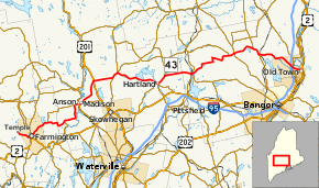
Route 43 begins at an intersection with Cummings Hill Road and Intervale Road in Temple. It heads east into Farmington. The route joins U.S. Route 2 and State Route 4. U.S Route 2 leaves the routes and State Route 27 joins the routes. Route 43 heads east and junctions State Route 148. State Route 148 stays just north of the route. Then the routes have a concurrency to Anson at U.S. Route 201A and State Route 8. Route 43 crosses a river into Madison and intersects U.S. Route 201. Route 43 continues to head east and has a concurrency with State Route 150. Then it has a concurrency with State Route 151. Then it has a concurrency with State Routes 23 and 152. Route 43 heads eastward again and now the route is finally alone. Then it turns northward with State Route 11. Then the routes intersect State Route 15. After East Corinth the route is alone again. But then it has a concurrency with State Route 221. Then the route heads southeast and crosses Interstate 95 and has its eastern end at U.S. Route 2.
Major junctions
| County | Location | mi[1] | km | Destinations | Notes |
|---|---|---|---|---|---|
| Franklin | Temple | 0.00 | 0.00 | Intervale Road / Cummings Hill Road | |
| Farmington | 4.53 | 7.29 | Western end of US 2 / SR 4 concurrencies | ||
| 4.68 | 7.53 | Eastern end of US 2 concurrency; western end of SR 27 concurrency | |||
| 5.32 | 8.56 | Eastern end of SR 4 / SR 27 concurrencies | |||
| Industry | 11.61 | 18.68 | Western terminus of SR 148 | ||
| Somerset | Starks | 17.50 | 28.16 | Northern terminus of SR 134 | |
| Anson | 24.35 | 39.19 | Western end of SR 148 concurrency | ||
| 25.75 | 41.44 | Western end of US 201A / SR 8 concurrency | |||
| Madison | 26.23 | 42.21 | Eastern end of US 201A / SR 8 / SR 148 concurrencies | ||
| 34.26 | 55.14 | Westbound traffic has a 0.05-mile (0.080 km) concurrency with US 201 | |||
| Cornville | 39.71 | 63.91 | Western end of SR 150 concurrency | ||
| Athens | 41.64– 41.66 | 67.01– 67.05 | Eastern end of SR 150 concurrency; western end of SR 151 concurrency | ||
| Hartland | 53.59 | 86.24 | Western end of SR 23 concurrency | ||
| 53.63 | 86.31 | Western end of SR 152 concurrency | |||
| 53.82 | 86.61 | Eastern end of SR 151 concurrency | |||
| St. Albans | 56.62 | 91.12 | Eastern end of SR 23 / SR 152 concurrencies | ||
| Penobscot | Corinna | 64.23 | 103.37 | Western end of SR 7 / SR 11 concurrencies | |
| 64.29 | 103.46 | Western terminus of SR 222 | |||
| 64.31 | 103.50 | Eastern end of SR 7 concurrency | |||
| Corinth | 78.46 | 126.27 | Eastern terminus of SR 94 | ||
| 80.09 | 128.89 | Western end of SR 15 concurrency | |||
| 80.21 | 129.09 | Eastern end of SR 11 / SR 15 concurrencies | |||
| Hudson | 86.46 | 139.14 | Western end of SR 221 concurrency | ||
| 88.76 | 142.85 | Eastern end of SR 221 concurrency | |||
| Old Town | 98.92– 99.12 | 159.20– 159.52 | Exit 197 (I-95) | ||
| 99.66 | 160.39 | ||||
| 102.72 | 165.31 | Eastern terminus of US 2A | |||
1.000 mi = 1.609 km; 1.000 km = 0.621 mi
| |||||
SR 43A
| |
|---|---|
| Location | Somerset County |
There used to be a State Route 43A. It used what is now part of State Route 148.
References
- "Maine DOT Map Viewer". Maine Office of GIS. Retrieved July 8, 2017.