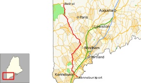
Maine State Route 35
State Route 35 (SR 35) runs the course of western Maine, from Kennebunk to Bethel. It passes through Oxford, Cumberland and York, Cumberland, and Oxford counties. It is known in its lower sections for both its unusually windy course as well as its notoriously poor paving, as a result of winter frost heaves. Its northern section leads to the famous ski resort, Sunday River. The route crosses the Presumpscot River and a well-preserved section of the Cumberland and Oxford Canal approximately one mile (1.6 km) west of U.S. Route 302 (US 302) in North Windham.
| ||||
|---|---|---|---|---|
 | ||||
| Route information | ||||
| Maintained by MaineDOT | ||||
| Length | 90.91 mi[1] (146.31 km) | |||
| Existed | 1964 (current alignment)–present | |||
| Major junctions | ||||
| South end | ||||
| North end | ||||
| Location | ||||
| Counties | York, Cumberland, Oxford | |||
| Highway system | ||||
| ||||

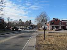
Northbound in Kennebunk
Junction list
| County | Location | mi | km | Destinations | Notes |
|---|---|---|---|---|---|
| York | Kennebunk | 0.00 | 0.00 | Southern terminus of SR 35 at SR 9. Eastern terminus of SR 9A at SR 9; eastern terminus of concurrency with SR 9A | |
| 3.5 | 5.6 | Northern terminus of wrong-way concurrency with US 1 | |||
| 3.6 | 5.8 | Northern terminus of concurrencies with US 1 and SR 9A | |||
| 5.3 | 8.5 | Kennebunk Service Plaza. | Exit 25 on I-95 (Maine Turnpike) | ||
| Lyman | 12.0 | 19.3 | |||
| Dayton | 17.0 | 27.4 | |||
| Hollis | 21.3 | 34.3 | Southern terminus of SR 4A and concurrency with SR 4A | ||
| 21.6 | 34.8 | Northern terminus of concurrency with SR 4A | |||
| 21.7 | 34.9 | ||||
| 26.7 | 43.0 | Moderation Street | |||
| Buxton | 29.5 | 47.5 | Western terminus of SR 22 | ||
| Cumberland | Standish | 33.3 | 53.6 | ||
| 35.4 | 57.0 | ||||
| 37.0 | 59.5 | Northern terminus of SR 237 | |||
| Windham | 42.3 | 68.1 | Eastern terminus of concurrency with US 302; western terminus of SR 115 | ||
| Raymond | 46.7 | 75.2 | Southern terminus of SR 85 | ||
| 47.2 | 76.0 | Southern terminus of SR 121 | |||
| Naples | 54.9 | 88.4 | Northern terminus of wrong-way concurrency with SR 11 | ||
| 55.8 | 89.8 | Northern terminus of concurrencies with US 302 and SR 11 | |||
| Harrison | 66.9 | 107.7 | Northern terminus of wrong-way concurrency with SR 117 | ||
| 67.2 | 108.1 | Southern terminus of wrong-way concurrency with SR 117 | |||
| Oxford | Waterford | 69.8 | 112.3 | Southern terminus of concurrency with SR 37 | |
| 72.5 | 116.7 | Northern terminus of concurrency with SR 37 | |||
| 77.1 | 124.1 | Western terminus of SR 118 | |||
| Albany Township | 78.1 | 125.7 | Southern terminus of concurrency with SR 5 | ||
| Bethel | 90.8 | 146.1 | Northern terminus of concurrency with SR 5 | ||
1.000 mi = 1.609 km; 1.000 km = 0.621 mi
| |||||
References
- "Maine DOT Map Viewer". Maine Office of GIS. Retrieved September 15, 2017.
External links

- Floodgap Roadgap's RoadsAroundME: Maine State Route 35
This article is issued from Wikipedia. The text is licensed under Creative Commons - Attribution - Sharealike. Additional terms may apply for the media files.