Maine State Route 133
State Route 133 (SR 133) is part of Maine's system of numbered state highways, running from U.S. Route 202 (US 202), SR 11, and SR 100 in Winthrop to US 2 and SR 4 in Farmington. The first two miles of the route runs concurrently with SR 41. The total length of SR 133 is 28.76 miles (46.28 km).
| ||||
|---|---|---|---|---|
 | ||||
| Route information | ||||
| Maintained by MaineDOT | ||||
| Length | 28.76 mi[1] (46.28 km) | |||
| Major junctions | ||||
| South end | ||||
| North end | ||||
| Location | ||||
| Counties | Kennebec, Androscoggin, Franklin | |||
| Highway system | ||||
| ||||

Route description
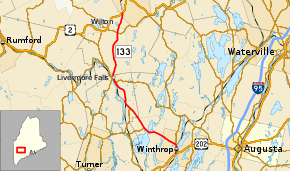
SR 133 (and SR 41) begins at the interchange with US 202/SR 11/SR 100 in Winthrop. Routes 133 and 41 run concurrently for about two miles (3.2 km) in Winthrop. After splitting from SR 41 in Winthrop, the road heads west towards Wayne, where it meets the eastern end of SR 219. After the SR 219 junction, it heads north to the northern end of SR 106 at Livermore Falls. After passing SR 106, SR 133 keeps going north to SR 17 in Livermore Falls. SR 17 marks the second time where SR 133 has a concurrency with another state highway. Upon leaving SR 17 in Livermore Falls, it heads north towards SR 156 in Jay. SR 133 ends at Farmington at the junction with US 202 and SR 4 after passing SR 156 in Jay.[2]
Major junctions
| County | Location | mi[1] | km | Destinations | Notes |
|---|---|---|---|---|---|
| Kennebec | Winthrop | 0.00– 0.41 | 0.00– 0.66 | Interchange; southern end of SR 41 concurrency | |
| 1.85– 1.88 | 2.98– 3.03 | Northern end of SR 41 concurrency | |||
| Wayne | 7.76 | 12.49 | Eastern terminus of SR 219 | ||
| Androscoggin | Livermore Falls | 11.74 | 18.89 | Northern terminus of SR 106 | |
| 16.87 | 27.15 | Southern end of SR 17 concurrency | |||
| 17.68 | 28.45 | Northern end of SR 17 concurrency | |||
| Franklin | Jay | 25.35 | 40.80 | ||
| Farmington | 28.76 | 46.28 | |||
1.000 mi = 1.609 km; 1.000 km = 0.621 mi
| |||||
References
- "Maine DOT Map Viewer". Maine Office of GIS. Retrieved August 2, 2017.
- Google (August 2, 2017). "Maine State Route 133" (Map). Google Maps. Google. Retrieved August 2, 2017.