Maine State Route 3
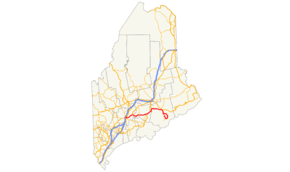
State Route 3 (abbreviated SR 3) is a 120.67-mile (194.20 km) long state highway located in southern Maine. Its western terminus is at State Route 8, State Route 11 and State Route 27 in Augusta. Its eastern terminus is at State Route 102 and State Route 198 in Mount Desert.
| ||||
|---|---|---|---|---|
 | ||||
| Route information | ||||
| Maintained by MaineDOT | ||||
| Length | 120.67 mi[1] (194.20 km) | |||
| Existed | 1933–present | |||
| Major junctions | ||||
| West end | ||||
| ||||
| East end | ||||
| Location | ||||
| Counties | Kennebec, Waldo, Hancock | |||
| Highway system | ||||
| ||||

As its single-digit number indicates, it is a major regional highway, connecting the Interstate 95 corridor to the Atlantic coast. Major cities and towns along the length of SR 3 include Augusta, Belfast, Ellsworth, and Bar Harbor.
Nearly one-third of the overall length of SR 3 is overlapped by U.S. Route 1.
Route description
SR 3 begins at Civic Center Drive (SR 8 / SR 11 / SR 27) in the northwest corner of Augusta. SR 3 heads east using the Augusta Bypass, a controlled-access road completed in 2004 to alleviate congestion in the city center caused by traffic headed to and from I-95. The bypass ends at North Belfast Avenue (US 202 / SR 9) on the east end of Augusta. SR 3 runs concurrently with US 202 and SR 9 (the Belfast Road) to the village of South China, where US 202 and SR 9 split to the north. SR 3 continues east to the city of Belfast, where it interchanges with US 1 west of downtown.
US 1 and SR 3 run concurrently for over 39 miles (63 km) from Belfast through Bucksport, crossing the Penobscot Narrows Bridge over the Penobscot River. SR 15 joins US 1 and SR 3 in downtown Bucksport and splits to the south in Orland after 4.4 miles (7.1 km). US 1 and SR 3 continue along the Acadia Highway to the city of Ellsworth.
SR 3 leaves US 1 at The Triangle, an intersection at the south end of Ellsworth that has been the center of numerous traffic problems within that city . Continuing south through Trenton, the route crosses a causeway to Mount Desert Island and intersects with SR 102 and SR 198, which run along the island's western side.
SR 3 turns east follows the eastern shore to the tourist town of Bar Harbor, then continues south through Acadia National Park to the village of Northeast Harbor. SR 3 intersects with SR 198 and turns north towards the village of Somesville. SR 3 and SR 198 intersect with SR 102 in Somesville; SR 3 ends and SR 198 turns north onto SR 102, eventually meeting SR 3 again near the Mount Desert Island causeway.
On the southern end of Mount Desert Island, and along the concurrency with SR 198, SR 3 signs lack directional indicators. This was intentionally done to avoid confusion, as a motorist on the southern part of the island driving on SR 3 west is actually traveling east (and vice versa). SR 3 signs along this stretch have "Route" in place of directional banners. Directional signs begin appearing westbound, and stop appearing eastbound, just east of Seal Harbor when the highway begins to loop around the island.
History
When originally designated in 1933, the western terminus of SR 3 was located in downtown Portland. It was overlaid on sections of SR 26, SR 4 and SR 11 between Portland and Augusta. In 1946-7, the western portion of the route was truncated to Augusta and its western terminus was moved to the intersection of Bangor Street and North Belfast Avenue, where it began cosigned with US 202 / SR 9.
In 2004, the Augusta Bypass was completed, providing a connection between I-95 and points east without the need to traverse downtown Augusta. SR 3 was rerouted onto the new bypass, proceeding northwest to a new interchange at exit 113. The bypass connected to North Belfast Avenue where SR 3 joined US 202 / SR 9 and continued its existing route eastward.
In 2013, the bypass was extended west of I-95 to connect with Old Belgrade Road and serve the new Alfond Center for Health and Cancer Center..[2] The Exit 113 interchange was reconfigured to provide full access and SR 3 was extended along the northern segment of Old Belgrade Road to its present western terminus at Civic Center Drive (SR 8 / SR 11 / SR 27), adding 1.48 miles (2.38 km) to its overall length.
East of Augusta, the routing of SR 3 has remained unchanged.
Junction list
| County | Location[3] | mi[3] | km | Destinations | Notes |
|---|---|---|---|---|---|
| Kennebec | Augusta | 0.00 | 0.00 | Western terminus | |
| 1.04– 1.57 | 1.67– 2.53 | Exit 113 on I-95 | |||
| 2.21 | 3.56 | ||||
| 3.25 | 5.23 | ||||
| 4.13 | 6.65 | Western terminus of US 202 / SR 9 concurrency | |||
| China | 13.34 | 21.47 | Western terminus of SR 32 concurrency | ||
| 14.60 | 23.50 | Eastern terminus of SR 32 concurrency | |||
| 14.82 | 23.85 | Eastern terminus of US 202 / SR 9 concurrency | |||
| Waldo | Liberty | 29.84 | 48.02 | ||
| Belmont | 40.05– 40.13 | 64.45– 64.58 | Brief concurrency with SR 131 | ||
| Belfast | 46.05– 46.10 | 74.11– 74.19 | Western terminus of US 1 concurrency | ||
| 46.60– 46.91 | 75.00– 75.49 | Interchange; westbound exit and eastbound entrance via High Street; southern terminus of SR 7 / eastern terminus of SR 137 | |||
| 47.40 | 76.28 | Southern terminus of SR 141 | |||
| Stockton Springs | 56.83 | 91.46 | Southern terminus of US 1A | ||
| Prospect | 62.94 | 101.29 | Eastern terminus of SR 174 | ||
| Penobscot River | 63.05– 63.26 | 101.47– 101.81 | Penobscot Narrows Bridge | ||
| Hancock | Bucksport | 64.51 | 103.82 | Western terminus of SR 15 concurrency | |
| Orland | 65.66 | 105.67 | Southern terminus of SR 46 | ||
| 66.28 | 106.67 | Northern terminus of SR 175 | |||
| 68.91 | 110.90 | Eastern terminus of SR 15 concurrency | |||
| 73.09 | 117.63 | Eastern terminus of SR 176 | |||
| Ellsworth | 83.45 | 134.30 | Northern terminus of SR 172 | ||
| 83.65 | 134.62 | Northern terminus of SR 230 | |||
| 83.93 | 135.07 | Eastern terminus of US 1A | |||
| 84.91– 85.64 | 136.65– 137.82 | Eastern terminus of US 1 concurrency | |||
| Trenton | 88.48 | 142.39 | Western terminus of SR 204 | ||
| 92.14 | 148.28 | Southern terminus of SR 230 | |||
| Bar Harbor | 93.37– 93.51 | 150.26– 150.49 | Northern terminus of SR 102 / SR 198 | ||
| 103.44 | 166.47 | Eastern terminus of SR 233 | |||
| Mount Desert | 115.04 | 185.14 | Southern terminus of SR 198 concurrency | ||
| 119.31 | 192.01 | Western terminus of SR 233 | |||
| 120.67 | 194.20 | Eastern terminus | |||
1.000 mi = 1.609 km; 1.000 km = 0.621 mi
| |||||
Concurrent routes
- U.S. Route 202 / State Route 9: 10.69 miles (17.20 km), Augusta to China
- State Route 32: 1.26 miles (2.03 km), China
- State Route 131: 0.08 miles (0.13 km), Belmont
- U.S. Route 1: 39.59 miles (63.71 km), Belfast to Ellsworth
- State Route 15: 4.40 miles (7.08 km), Bucksport to Orland
- State Route 198: 5.63 miles (9.06 km), Mount Desert
See also
- List of state highways in Maine
References
- Maine State Route Log via floodgap.com Archived 2011-06-12 at Archive.today
- "Two new roundabouts at Interstate 95 exit 113 open in north Augusta". Kennebec Journal & Morning Sentinel. 2013-10-28. Retrieved 2017-09-23.
- "MaineDOT Public Map Viewer". Maine Department of Transportation. Retrieved April 18, 2017.
External links
![]()