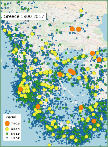
List of earthquakes in Greece
This list of earthquakes in Greece includes notable earthquakes that have affected Greece during recorded history. This list is currently incomplete, representing only a fraction of the possible events.
Tectonic setting
Greece is located at the complex boundary zone in the eastern Mediterranean between the African Plate and the Eurasian Plate. The northern part of Greece lies on the Eurasian Plate while the southern part lies on the Aegean Sea Plate. The Aegean Sea Plate is moving southwestward with respect to the Eurasian Plate at about 30 mm/yr while the African Plate is subducting northwards beneath the Aegean Sea Plate at a rate of about 40 mm/yr. The northern plate boundary is a relatively diffuse divergent boundary while the southern convergent boundary forms the Hellenic arc.[1]
These two plate boundaries give rise to two contrasting tectonic styles, extension on east–west trending fault zones with strike-slip tectonics on SW-NE trending fault zones throughout west and central Greece, Peloponnese and the northern Aegean and contractional in the southern Aegean, continuing around to the Ionian islands. The south Aegean is the location of the volcanic arc and is characterised by extension. To the east of Crete along the Hellenic Arc, strike-slip tectonics with some extension become important.[1]
The strongest earthquakes historically are those associated with the Hellenic Arc, although none larger than about 7.2 have been observed instrumentally. The events of AD 365 and 1303 are likely to have been much larger than this. In mainland Greece, normal faulting gives earthquakes up to 7 in magnitude, while in the northern Aegean, strike-slip events with a magnitude of 7.2 have been recorded. Large intermediate depth (>50 km) earthquakes of magnitude >7 from within the subducting African Plate have been recorded but such events cause little damage, although they are widely felt.[1]
Earthquakes
| Date | Place | Lat | Lon | Deaths | Mag. | I | Comments | Sources |
|---|---|---|---|---|---|---|---|---|
| 2019-11-27 | Aegean Sea, offshore Antikythera | 35.63 | 23.21 | 6.1 Mw | VI | Depth of focus reached 56 km, making it perceived from more than 300 km away. Some damage.[2] | CNN[3] | |
| 2018-10-26 | Ionian Sea, offshore Zakynthos | 37.478 | 20.56 | 6.8 Mw | VI | Sea level changes were observed, prompting a local tsunami warning. | USGS[4] | |
| 2017-07-21 | Kos | 36.57 | 27.27 | 2 | 6.6 Mw | VII | 150 people injured in Greece, 370 injured in Turkey and two dead | BBC |
| 2017-06-12 | Lesbos | 38.93 | 26.37 | 1 | 6.3 Mw | IX | 10+ people injured, significant damage across parts of the island | |
| 2015-11-17 | Lefkada | 38.67 | 20.6 | 2 | 6.5 Mw | VII | Four injured | [5] |
| 2014-05-24 | Limnos | 38.11 | 23.60 | 1 | 6.9 Mw | VIII | 1 injury reported in Greece, dozens of houses collapsed. | |
| 2008-07-15 | Dodecanese | 35.93 | 27.81 | 1 | 6.4 Mw | VII | ||
| 2008-06-22 | Methoni, Messenia, Peloponnese | 36.00 | 21.90 | 6.0 Mw | VIII | There were four foreshocks before the main event / Earthquake swarm starting 14 February | [6] | |
| 2008-06-08 | Peloponnese | 37.96 | 21.53 | 2 | 6.4 Mw | VIII | 240 injured | |
| 2008-02-20 | Methoni, Messenia, Peloponnese | 37.96 | 21.53 | 6.1 Mw | V | Earthquake swarm | [7] | |
| 2008-02-14 | Methoni, Messenia, Peloponnese | 37.96 | 21.53 | 6.7 Mw & 6.6 Mw | V+ | Back to back seismic events in the span of two hours approximately / Minor damages / Earthquake swarm that continued throughout the year | [8] | |
| 2008-01-06 | Leonidio, Arcadia | 6.6 Mw | [9] | |||||
| 2006-01-08 | Kythira | 36.26 | 23.46 | 6.7-6.9 Mw | VII | Three injured | [10] | |
| 2005-10-18 | Zakynthos | 6.0 Mw | No injuries or damages | [11] | ||||
| 2003-08-14 | Lefkada | 39 | 21 | 6.4 Mw | VIII | [12] | ||
| 2002-01-22 | Crete - Karpathos | 35.56 | 26.73 | 6.6 Mw | No injuries or damages | [13] | ||
| 1999-09-07 | Athens | 38.06 | 23.51 | 143 | 6.0 Mw | IX | 1,600 injured / $3–4.2 billion in damage | |
| 1995-06-15 | Aigio | 38.40 | 22.28 | 26 | 6.4 Mw | VIII | 60 injuries / $660 million in damage | NGDC,[14] |
| 1995-05-13 | Kozani–Grevena | 40.15 | 21.70 | 6.6 Mw | VIII | 12-25 injured / $450 million in damage | NGDC,[15] | |
| 1990-12-21 | Goumenissa, Kilkis–Pella | 40.92 | 22.36 | 1 | 6.0 Mw | VI | 60 injured | [16] |
| 1990-06-16 | Preveza (regional unit) | 39.1 | 20.4 | 6.0 M | VI | 1 injured | [17] | |
| 1988-10-16 | Kyllini, Elis | 6.0 M | [18] | |||||
| 1986-09-13 | Kalamata | 37.01 | 22.18 | 20+ | 6.0 Mw | X | 300 injured / $5 million in damage | [19] |
| 1981-12-19 | Lesbos | 39.00 | 25.26 | 7.2 | VIII | 7 buildings collapsed | [20] | |
| 1981-02-24 | Halcyon islands, Gulf of Corinth | 38.22 | 22.93 | 20-22 | 6.7 Ms | VIII | 400-500 injured / $812 million in damage / 22,554 buildings destroyed / Local tsunami | [21][22] |
| 1980-07-09 | Almyros, Magnesia (regional unit) | 39.27 | 22.83 | 6.5 | VIII | 24 injured / 5,222 buildings completely destroyed | [23] | |
| 1978-06-20 | Thessaloniki | 40.6 | 23.2 | 45–50 | 6.2 - 6.5 Mw | VIII | 100–220 injured | [24] |
| 1973-11-29 | Palaiochora, Crete | 35.18 | 23.75 | 6.0 Mw | VII+ | [25] | ||
| 1968-02-19 | Agios Efstratios, Aegean Sea | 39.37 | 25.96 | 20 | 7.1 - 7.2 Mw | X | 39 injuries / Local tsunami | NGDC,[26] |
| 1967-05-01 | Drosopighe, Arta (regional unit) | 39.47 | 21.25 | 9 | 6.4 | IX | 56 injured | [27] |
| 1966-10-29 | Katouna, Aetolia-Acarnania | 38.78 | 21.11 | 1 | 6.0 | VIII | 43 injured | [28] |
| 1966-09-01 | Megalopolis, Greece, Arcadia | 37.39 | 22.14 | 6.0 | VIII | 24 injured | [29] | |
| 1966-02-05 | Kremasta (lake), Evrytania | 39.05 | 21.75 | 1 | 6.2 | IX | 65 injured / 731 buildings collapsed | [30] |
| 1965-07-06 | Erateini, Phocis | 38.27 | 22.30 | 1 | 6.3 | VIII | 6 injured / 575 buildings collapsed | [31] |
| 1965-04-09 | Kandanos, Crete | 35.13 | 24.31 | 6.1 | VI+ | [32] | ||
| 1965-04-05 | Apiditsa, Arcadia | 37.40 | 22.10 | 18 | 6.1 | VIII | 17 injured / 1,426 buildings collapsed | [33] |
| 1965-03-09 | Alonnisos | 39.16 | 23.89 | 2 | 6.1 | IX | 2 injured / 1941 buildings collapsed | [34] |
| 1959-05-14 | Pitsidia, Crete | 35.00 | 24.72 | 6.3 | VIII+ | 8 injured | [35] | |
| 1957-04-25 | Rhodes | 36.50 | 28.60 | 7.2 | VIII | In Turkish coast there were 18 fatalities and 3,000 buildings destroyed | [36] | |
| 1956-07-09 | Dodecanese | 36.67 | 25.957 | 53 | 7.5 Mw | IX | Triggered a tsunami that affected the entire Aegean Sea / 100 injuries | [37] |
| 1955-07-16 | Samos - Agathonisi | 37.55 | 27.05 | 6.9 | VIII | 2 injured | [38] | |
| 1955-04-19 | Lechonia, Magnesia (regional unit) | 39.37 | 23.00 | 1 | 6.2 | VIII | 41 injured | [39] |
| 1954-04-30 | Sofades, Karditsa (regional unit) | 39.28 | 22.29 | 25-31 | 6.7-7.0 Mw | IX | 6,559 buildings destroyed | [40][41] |
| 1953-10-21 | Kandila, Aetolia-Acarnania | 38.60 | 20.96 | 6.3 | VIII | [42] | ||
| 1953-08-09 | Cephalonia, Zakynthos | 38.18 | 20.94 | 445–800 | 6.4 Mw, 6.8 Mw & 7.2 Mw | X | Two foreshocks and one major earthquake occurred in the span of three days / 2,412 injured / The islands of Cephalonia, Zakynthos and Ithaca were leveled. From the 33,300 buildings of these three islands, 27,659 were completely destroyed | [43] |
| 1947-10-06 | Messenia, Peloponnese | 36.96 | 21.68 | 3 | 7.0 | IX | 20 injured | [44] |
| 1941-03-01 | Larissa, Thessaly | 39.67 | 22.54 | 40 | 6.3 | VIII | 100 injured / In Larissa, 10% of the city's buildings have been completely destroyed and 60% seriously damaged | [45] |
| 1938-07-20 | Oropos, East Attica | 38.29 | 23.79 | 18 | 6.0 | VIII | 107 injured / 8,000 homeless | [46] |
| 1933-04-23 | Kos | 36.8 | 27.3 | 74-200 | 6.6 | IX–X | 600 injuries | [47][48] |
| 1932-09-26 | Ierissos | 39.8 | 23.8 | 161-491 | 7.0 Ms | X | Tsunami / 669 injuries / 4,106 buildings destroyed | [49] |
| 1928-04-22 | Corinth | 38 | 23 | 20 | 6.0 Ms | IX | 3,000 homes destroyed / tsunami | NGDC |
| 1917-12-24 | Nafpaktos | 38.40 | 21.70 | 6.0 | VIII | [50] | ||
| 1914-11-27 | Lefkada | 38.72 | 20.62 | 16 | 6.3 | IX | Small tsunami | ,[51][52] |
| 1904-08-11 | Samos | 37.66 | 26.93 | 4 | 6.8 | VIII | 7 injuries / 540 buildings destroyed | [53] |
| 1902-08-11 | Assiros, Thessaloniki (regional unit) | 5 | 7.9 Ms | IX | [54] | |||
| 1895-05-14 | Paramythia, Thesprotia | 75 | 6.3 Mw | 46 injuries | [55] | |||
| 1894-04-27 | Atalanti | 38.65 | 23.08 | 255 | 6.7 Mw & 7.0 Mw | XI | Two earthquakes, 7 days apart / 3,783 buildings destroyed | [56] |
| 1893-05-23 | Thebes | 38.31 | 23.25 | 2 | 6.2 | VIII | [57] | |
| 1893-04-17 | Zakynthos | 6.4 | IX | From 4,500 buildings of the island, 2,000 were completely destroyed | [58] | |||
| 1889-10-13/14 | Lesbos | 36 | 6.7 | 200 injuries | [59] | |||
| 1893-02-09 | Samothrace | 40.59 | 25.53 | 1 | 6.8 | IX | 10-20 injuries | [60] |
| 1886-08-27 | Filiatra | 37.10 | 21.50 | 326-600 | 7.5 | X | 796 injuries / 6,000 buildings collapsed or severely damaged / 123 villages destroyed/ Tsunami | NGDC,[61] |
| 1881-04-03 | Chios, Çeşme, Alaçatı | 38.30 | 26.20 | 3,550 | 6.5-7.3 | XI | 7,000 injured | [62] |
| 1870-08-01 | Arachova | 38.48 | 22.55 | 117 | 6.8 | VIII | 380 injured / 2,000 buildings destroyed | [63] |
| 1869-12-16 | Lefkada | 15 | 6.4 | Only 20-25 houses were saved | [64] | |||
| 1867-03-07 | Lesbos | 39.2 | 26.4 | 550 | 6.8-7.0 | X | 816 injured / 10,275 buildings were damaged | NGDC,[65] |
| 1867-02-04 | Lixouri, Cephalonia | 38.4 | 20.2 | 200-224 | 7.2 | X | 2,612 buildings collapsed | NGDC,[66] |
| 1866-01-31 | Santorini | 6.1 | VIII | The volcano of Nea Kameni erupted and began creating two islets | [67] | |||
| 1865-07-23 | Lesbos | 10 | 6.7 | IX | ,[68][59] | |||
| 1861-02-04 | Valimitika, Achaea | 38.25 | 22.16 | 20 | 6.7 | X | Tsunami wave at the Gulf of Corinth | [69] |
| 1858-02-09 | Corinth | 21 | 6.7 | 65 injuries | [70] | |||
| 1856-10-12 | Rhodes, Crete | 35.5 | 26 | 538 | 8.2 | XI | 638 injuries / 16,512 homes destroyed / tsunami | NGDC,[71] |
| 1853-08-18 | Thebes, Greece | 13 | 6.8 | Destroyed most of the buildings of city of Thebes | NGDC,[72] | |||
| 1846-06-11 | Messini, Messenia | 30 | 6.5 | 2.500 buildings destroyed | NGDC,[73][74] | |||
| 1840-10-30 | Zakynthos | 38 | 21 | 12 | X | NGDC | ||
| 1837-03-20 | Hydra (island), Saronic Gulf | 1 | 6.2 Mw | VII | [75] | |||
| 1829-05-05 | Xanthi, Western Thrace | 41.1 | 24.5 | 7.3 Mw | IX | The city of Xanthi was almost destroyed. Drama (X) was almost completely destroyed, as well as many villages in the municipal county. | [76] | |
| 1825-01-19 | Lefkada | 6.5 Mw | X | [77] | ||||
| 1817-08-23 | Helike | 6.6 Mw | ||||||
| 1810-02-16 | Crete, Heraklion | 35.5 | 25.6 | 2,000 | 7.5 Mw | X | ||
| 1804-06-08 | Patras | 38.1 | 21.7 | 10 | 6.4 Mw | IX | [78][79] | |
| 1752-07-29 | East Thrace | 41.41 | 26.61 | >100 | 7.5 Mw | VIII | The cities of Havsa (IX) and Haskoy were leveled while Andrianoupolis (Edirne) and other cities of East Thrace suffered great damage. | [80][81] |
| 1481-05-03 | Rhodes | 36.0 | 28.0 | 30,000 | 7.1 Ms | X | Tsunami | |
| 1303-08-08 | Crete, Alexandria | 35.0 | 27.0 | Many thousands | ~8 | IX | Triggered a major tsunami; severely damaged the Lighthouse of Alexandria | |
| Dec 856 | Corinth | 37.9 | 22.9 | 45,000 | [82] | |||
| 515 | Rhodes | Ambraseys states that the death toll in this nighttime event was high and that the damage was severe | [83] | |||||
| 365-07-21 | Crete, Alexandria | 35.0 | 23.0 | Many thousands | 8.5+ | Raised part of Crete 9 metres, causing severe damage and triggering a tsunami that devastated Alexandria | ||
| 226 BC | Rhodes | 36.43 | 28.21 | Toppled the Colossus of Rhodes | ||||
| 426 BC | Skarfeia, Euboic Gulf | 38.85 | 22.78 | 2,550 | 7.0 | IX | The historian Thucydides concluded that the Malian Gulf tsunami of the same year was caused by the earthquake, the first to recognize such a link | [84][85] |
| 464 BC | Sparta | 37.08 | 22.43 | ~20,000 | 7.2 Ms |
See also
References
- USGS (29 March 2010). "Tectonic Summary of Greece". Archived from the original on 29 July 2010. Retrieved 26 July 2010.
- "Σεισμός Κρήτη: Ζημιές από την ισχυρή σεισμική δόνηση - Έκλεισαν προληπτικά τα σχολεία". www.newsbomb.gr. 27 November 2019.
- "Σεισμός 6,1 Ρίχτερ ανάμεσα σε Κρήτη και Κύθηρα - Αισθητός και στην Αθήνα". www.cnn.gr. 27 November 2019.
- USGS. "M 6.8 - 32km SW of Mouzaki, Greece". United States Geological Survey. Retrieved 2018-10-25.
- USGS. "M6.5 - 10km WSW of Nidri, Greece". United States Geological Survey.
- Earthquake Planning and Protection Organization (EPPO). "Methoni 2008/6". E.P.P.O. Retrieved 2019-11-30.
- Earthquake Planning and Protection Organization (EPPO). "Methoni 20/02/2008". E.P.P.O. Retrieved 2019-12-02.
- Earthquake Planning and Protection Organization (EPPO). "Methoni 2008/2". E.P.P.O. Retrieved 2019-11-30.
- Earthquake Planning and Protection Organization (EPPO). "Leonidio 2008". E.P.P.O. Retrieved 2019-11-30.
- Earthquake Planning and Protection Organization (EPPO). "Kythira 2006". E.P.P.O. Retrieved 2019-11-29.
- Earthquake Planning and Protection Organization (EPPO). "Zakynthos 18/10/2005". E.P.P.O. Retrieved 2019-12-02.
- Earthquake Planning and Protection Organization (EPPO). "Lefkada 2003". E.P.P.O. Retrieved 2019-11-28.
- Earthquake Planning and Protection Organization (EPPO). "Crete 22/01/2002". E.P.P.O. Retrieved 2019-12-02.
- Earthquake Planning and Protection Organization (EPPO). "Aegio / Erateini 1995 (VI)". E.P.P.O. Retrieved 2019-11-29.
- Earthquake Planning and Protection Organization (EPPO). "May 13, 1995". E.P.P.O. Retrieved 2019-12-02.
- Earthquake Planning and Protection Organization (EPPO). "Kilkis 1990". E.P.P.O. Retrieved 2019-11-28.
- Earthquake Planning and Protection Organization (EPPO). "Preveza 1990". E.P.P.O. Retrieved 2019-11-28.
- Earthquake Planning and Protection Organization (EPPO). "October 16, 1988". E.P.P.O. Retrieved 2019-12-02.
- USGS. "M6.0 - southern Greece". United States Geological Survey.
- Earthquake Planning and Protection Organization (EPPO). "Equine 1981 (VIII)". E.P.P.O. Retrieved 2019-11-28.
- NGDC. "Comments for the Significant Earthquake". Retrieved 1 October 2013.
- Earthquake Planning and Protection Organization (EPPO). "Halcyon Perachora 1981". E.P.P.O. Retrieved 2019-11-29.
- Earthquake Planning and Protection Organization (EPPO). "Salty 1980 (VIII)". E.P.P.O. Retrieved 2019-11-29.
- Earthquake Planning and Protection Organization (EPPO). "June 20, 1978". E.P.P.O. Retrieved 2019-12-02.
- Earthquake Planning and Protection Organization (EPPO). "Chania - Palaiohora 1973 (VII +)". E.P.P.O. Retrieved 2019-11-30.
- Earthquake Planning and Protection Organization (EPPO). "February 19, 1968". E.P.P.O. Retrieved 2019-12-02.
- Earthquake Planning and Protection Organization (EPPO). "Drosopigi 1967 (IX)". E.P.P.O. Retrieved 2019-11-29.
- Earthquake Planning and Protection Organization (EPPO). "Katouna 1966 (VIII)". E.P.P.O. Retrieved 2019-11-29.
- Earthquake Planning and Protection Organization (EPPO). "Megalopolis 1966 (VIII)". E.P.P.O. Retrieved 2019-11-30.
- Earthquake Planning and Protection Organization (EPPO). "Kremasta 1966". E.P.P.O. Retrieved 2019-11-29.
- Earthquake Planning and Protection Organization (EPPO). "Erateini 1965 (VIII)". E.P.P.O. Retrieved 2019-11-29.
- Earthquake Planning and Protection Organization (EPPO). "Chania - Kandanos 1965 (VI +)". E.P.P.O. Retrieved 2019-11-30.
- Earthquake Planning and Protection Organization (EPPO). "Apiditsa 1965 (X)". E.P.P.O. Retrieved 2019-11-30.
- Earthquake Planning and Protection Organization (EPPO). "Alonnissos 1965 (IX)". E.P.P.O. Retrieved 2019-11-29.
- Earthquake Planning and Protection Organization (EPPO). "Heraklion - Pitsidia 1959 (VIII)". E.P.P.O. Retrieved 2019-11-30.
- Earthquake Planning and Protection Organization (EPPO). "Rhodes 1957 (VIII)". E.P.P.O. Retrieved 2019-12-02.
- Earthquake Planning and Protection Organization (EPPO). "July 9, 1956". E.P.P.O. Retrieved 2019-12-02.
- Earthquake Planning and Protection Organization (EPPO). "Samos - Agathonissi 1955 (VIII)". E.P.P.O. Retrieved 2019-11-30.
- Earthquake Planning and Protection Organization (EPPO). "Lehonia 1955 (VIII)". E.P.P.O. Retrieved 2019-11-29.
- USGS. "M 6.7 - Greece". United States Geological Survey. Retrieved 2019-06-27.
- Earthquake Planning and Protection Organization (EPPO). "Sofades 1954 (IX)". E.P.P.O. Retrieved 2019-11-29.
- Earthquake Planning and Protection Organization (EPPO). "Kandila 1953 (VIII)". E.P.P.O. Retrieved 2019-11-29.
- Earthquake Planning and Protection Organization (EPPO). "Argostoli 1953 (X)". E.P.P.O. Retrieved 2019-11-29.
- Earthquake Planning and Protection Organization (EPPO). "Messinia 1947 (IX)". E.P.P.O. Retrieved 2019-11-30.
- Earthquake Planning and Protection Organization (EPPO). "Larisa 1941 (VIII)". E.P.P.O. Retrieved 2019-11-28.
- Earthquake Planning and Protection Organization (EPPO). "Oropos 1938 (VIII)". E.P.P.O. Retrieved 2019-11-29.
- Utsu 2002, p. 705
- Earthquake Planning and Protection Organization (EPPO). "April 23, 1933". E.P.P.O. Retrieved 2019-12-02.
- Earthquake Planning and Protection Organization (EPPO). "Ierissos 1932 (X)". E.P.P.O. Retrieved 2019-12-02.
- Earthquake Planning and Protection Organization (EPPO). "Naypaktos 1917 (VIII)". E.P.P.O. Retrieved 2019-11-29.
- Earthquake Planning and Protection Organization (EPPO). "Lefkada 1914 (IX)". E.P.P.O. Retrieved 2019-11-29.
- Earthquake Planning and Protection Organization (EPPO). "November 27, 1914". E.P.P.O. Retrieved 2019-12-02.
- Earthquake Planning and Protection Organization (EPPO). "Samos 1904 (VIII)". E.P.P.O. Retrieved 2019-11-30.
- Earthquake Planning and Protection Organization (EPPO). "Assiros 1902 (IX)". E.P.P.O. Retrieved 2019-11-28.
- paramythia-online.gr. "MAY 14, 1895: THE FATAL EARTHQUAKE OF PARAMYTHIA 03:06". paramythia-online.gr. Retrieved 2019-12-09.
- Earthquake Planning and Protection Organization (EPPO). "Saint Konstantinos 1984 (X)". E.P.P.O. Retrieved 2019-11-29.
- Earthquake Planning and Protection Organization (EPPO). "Thebes 1893 (VIII)". E.P.P.O. Retrieved 2019-11-29.
- Earthquake Planning and Protection Organization (EPPO). "Zakynthos - Keri 1893 (IX)". E.P.P.O. Retrieved 2019-11-29.
- Michalis Stoukas. "The earthquakes of Lesvos and Chios from antiquity to the present day". protothema.gr. Retrieved 2019-12-09.
- Earthquake Planning and Protection Organization (EPPO). "Samothrakis 1893 (IX)". E.P.P.O. Retrieved 2019-11-28.
- Earthquake Planning and Protection Organization (EPPO). "Filiatra 1886". E.P.P.O. Retrieved 2019-11-30.
- Earthquake Planning and Protection Organization (EPPO). "Chios 1881 (XI)". E.P.P.O. Retrieved 2019-11-29.
- Earthquake Planning and Protection Organization (EPPO). "August 1, 1870". E.P.P.O. Retrieved 2019-12-02.
- Th. Angelis. "EARTHQUAKE IN LEFKADA". lefkadapress.gr. Retrieved 2019-12-09.
- Earthquake Planning and Protection Organization (EPPO). "Kloumidados 1867 (X)". E.P.P.O. Retrieved 2019-11-28.
- Earthquake Planning and Protection Organization (EPPO). "Lixuri 1867 (X)". E.P.P.O. Retrieved 2019-11-28.
- Earthquake Planning and Protection Organization (EPPO). "Santorini 1866 (VIII)". E.P.P.O. Retrieved 2019-11-30.
- George Pagoudis. "6.1R cracked Lesvos". efsyn.gr. Retrieved 2019-12-09.
- Earthquake Planning and Protection Organization (EPPO). "Corinth Gulf 1861 (Ass. Valimitika)". E.P.P.O. Retrieved 2019-11-30.
- Theofrastos Digital Library - Department of Geology. AUTH, 30 PANHELLENIOGRAPHICAL CONFERENCE 1993, iellada.gr, oasp.gr, argolikivivliothiki.gr. "ANCIENT CORINTH 9 FEBRUARY 1858-161 YEARS FROM DESTRUCTIVE EARTHQUAKE". Ap. Sfirakis (blogger). Retrieved 2019-12-08.CS1 maint: multiple names: authors list (link)
- Earthquake Planning and Protection Organization (EPPO). "October 12, 1856". E.P.P.O. Retrieved 2019-12-02.
- Anthi Sakka. "Thebes of Boeotia: The Focal Point of Greek History (Part A)". MaxMag. Retrieved 2019-12-08.
- Elias Bitsanis. "An earthquake that leveled Island and villages in May 1846 (Part I)". Eleftheria Online.gr. Retrieved 2019-12-08.
- Elias Bitsanis. "An earthquake that leveled Island and villages in May 1846 (Part II)". Eleftheria Online.gr. Retrieved 2019-12-08.
- Earthquake Planning and Protection Organization (EPPO). "Hydra 1837 (VII)". E.P.P.O. Retrieved 2019-11-29.
- Earthquake Planning and Protection Organization (EPPO). "Xanthi 1829 (Epicenter Drama)". E.P.P.O. Retrieved 2019-11-28.
- Earthquake Planning and Protection Organization (EPPO). "January 19, 1825". E.P.P.O. Retrieved 2019-12-02.
- ΙΝΣΤΙΤΟΥΤΟ ΤΕΧΝΙΚΗΣ ΣΕΙΣΜΟΛΟΓΙΑΣ & ΑΝΤΙΣΕΙΣΜΙΚΩΝ ΚΑΤΑΣΚΕΥΩΝ. "Ο ΣΕΙΣΜΟΣ ΑΧΑΪΑΣ - ΗΛΕΙΑΣ" (PDF). ΙΝΣΤΙΤΟΥΤΟ ΤΕΧΝΙΚΗΣ ΣΕΙΣΜΟΛΟΓΙΑΣ & ΑΝΤΙΣΕΙΣΜΙΚΩΝ ΚΑΤΑΣΚΕΥΩΝ. Retrieved 2019-12-04.
- Imerisia.gr/ patris.gr/ CretePlus.gr. "Αυτοί είναι οι φονικότεροι σεισμοί στην Ελλάδα- 16 Φεβρουαρίου 1810, ο σεισμός των 7,8 Ρίχτερ στο Ηράκλειο!". CretePlus.gr. Retrieved 2019-12-04.
- Earthquake Planning and Protection Organization (EPPO). "A. Thraki 1752 (VIII)". E.P.P.O. Retrieved 2019-11-28.
- Ambraseys, N.N. (2009). Earthquakes in the Mediterranean and Middle East: A Multidisciplinary Study of Seismicity up to 1900. ISBN 9781316347850.
- IISEENET (Information Network of Earthquake disaster Prevention Technologies) - Search Page
- Ambraseys, N. (2009). Earthquakes in the Mediterranean and Middle East: A Multidisciplinary Study of Seismicity up to 1900 (First ed.). Cambridge University Press. p. 180. ISBN 978-0521872928.
- Antonopoulos, J. (1992). "The Tsunami of 426 BC in the Maliakos Gulf, Eastern Greece". Natural Hazards. 5: 83–93. doi:10.1007/BF00127141.
- Earthquake Planning and Protection Organization (EPPO). "Skarfia 426 BC (IX)". E.P.P.O. Retrieved 2019-11-29.
Sources
- NGDC (1972), Significant Earthquake Database (Data Set), National Geophysical Data Center, NOAA, doi:10.7289/V5TD9V7K
- Utsu, T. R. (2002), "A List of Deadly Earthquakes in the World: 1500–2000", International Handbook of Earthquake & Engineering Seismology, Part A, Volume 81A (First ed.), Academic Press, ISBN 978-0124406520
| Authority control |
|
|---|