List of World Heritage Sites in the Arab states
This is a list of World Heritage Sites in the Arab states,[1] in Western Asia and North Africa, occupying an area stretching from the Atlantic Ocean in the west to the Arabian Sea in the east, and from the Mediterranean Sea.
List
The list below contains an image of the site or part of the site; the name as inscribed by UNESCO; the location; the nominating state party; the criteria met by the site, including if it is a cultural, natural or mixed; the area in hectares and acres, excluding any buffer zones, with a value of zero implying that no data is published by UNESCO; the year the site was inscribed; and a description of the site.
† In danger
| Site | Image | Location | Criteria | Area ha (acre) |
Year | Description |
|---|---|---|---|---|---|---|
| Djémila | 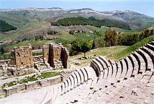 |
Sétif Province, 36°19′14″N 5°44′12″E |
Cultural: (iii)(iv) |
31 (77) | 1982 | Djémila (formerly known as Cuicul) was a Roman town in a mountainous site, comprising a forum, temples, basilicas, triumphal arches and religious buildings and other structures, each adapted to a location 900 m (3,000 ft) above sea level.[2] |
| Kasbah of Algiers | 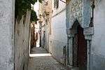 |
Algiers Province, 36°47′00″N 3°03′37″E |
Cultural: (ii)(v) |
50 (120) | 1982 | The Kasbah of Algiers is a unique Islamic city on the Mediterranean coast. It contains remains of a citadel, medieval mosques and Ottoman palaces.[3] |
| M'zab Valley |  |
Ghardaïa Province, 32°29′00″N 3°41′00″E |
Cultural: (ii)(iii)(v) |
4,000 (9,900) | 1982 | The intact, traditional human habitat was built around five ksour of the M'zab Valley in the 10th century by the Ibadites.[4] |
| Tassili n'Ajjer | 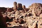 |
Illizi and Tamanrasset Provinces, 25°30′00″N 9°00′00″E |
Mixed: (i)(iii)(vii)(viii) |
7,200,000 (18,000,000) | 1982 | A vast plateau on the edge of the Sahara, Tassili n'Ajjer contains more than 15,000 cave engravings that record climatic changes, animal migrations, and the evolution of human life, dating from 6,000 BCE to the first centuries CE. It is also noted for its eroded sandstone landforms.[5] |
| Timgad | 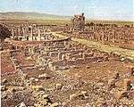 |
Batna Province, 35°27′00″N 6°38′00″E |
Cultural: (ii)(iii)(iv) |
91 (220) | 1982 | Established by Emperor Trajan in 100 CE as a military colony, Timgad features cardo and decumanus streets, constituting a typical example of Roman town-planning.[6] |
| Tipasa | 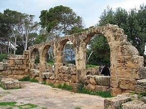 |
Tipaza Province, 36°32′00″N 2°22′00″E |
Cultural: (iii)(iv) |
52 (130) | 1982 | Previously a Carthaginian trading centre, Tipasa was conquered by the Romans and converted into a military base. The site also bears witness to paleochristian and Byzantine influences.[7] |
| Dilmun Burial Mounds | 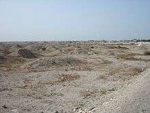 |
Northern Governorate, 26°8′59″N 50°30′46″E |
Cultural: (iii)(iv) |
168.45 (416.2) | 2019 | Located in the western part of Bahrain Island, Dilmun Burial Mounds date back to the Dilmun, the Umm al-Nar culture. They were built between 2050 and 1750 BCE include 21 archaeological sites with more than 11 K burial mounds and 17 royal mounds built as 2-storeyed funeral towers.[8] |
| Qal'at al-Bahrain – Ancient Harbour and Capital of Dilmun |  |
Northern Governorate, 26°13′59″N 50°31′38″E |
Cultural: (ii)(iii)(iv) |
32 (79) | 2005 | Qal'at al-Bahrain was the capital of the Dilmun civilization, bearing witness to continuous human occupation from circa 2300 BC to the present. A Portuguese fort stands on the top of the site.[9] |
| Pearling, Testimony of an Island Economy |  |
26°14′28″N 50°36′49″E |
Cultural: (iii) |
35,087 (86,700) | 2012 | Consisting of buildings in Muharraq, oyster beds, a segment of the coast and a fortress, the site testifies to the pearling tradition that dominated the Arabian Gulf from the 2nd century to the early 20th century, when the introduction of cultured pearls from Japan resulted in the crash of pearling economy in Bahrain.[10] |
| Abu Mena | 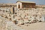 |
Alexandria Governorate, 30°51′00″N 29°40′00″E |
Cultural: (iv) |
183 (450) | 1979 | The ruins of the former Christian holy city contain a church, a baptistery, basilicas, public buildings, streets, monasteries, houses, and workshops, and were built over the tomb of Menas of Alexandria.[11] |
| Ancient Thebes with its Necropolis | 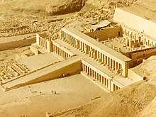 |
Luxor Governorate, 25°44′00″N 32°36′00″E |
Cultural: (i)(iii)(vi) |
7,390 (18,300) | 1979 | The former capital of Egypt and the city of Amun, Thebes contains temples and palaces at Karnak and Luxor, as well as the necropolises at the Valley of the Kings and the Valley of the Queens, bearing witness to the height of the Egyptian civilization.[12] |
| Historic Cairo | .jpg) |
Cairo Governorate, 30°03′00″N 31°15′40″E |
Cultural: (i)(v)(vi) |
524 (1,290) | 1979 | One of the world's oldest Islamic cities and in the middle of urban Cairo, the site dates from the 10th century and reached its golden age in the 14th century. It contains mosques, madrasah, hammams and fountains.[13] |
| Memphis and its Necropolis – the Pyramid Fields from Giza to Dahshur | 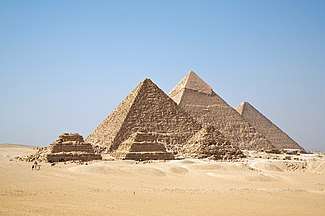 |
Giza Governorate, 30°03′00″N 31°15′40″E |
Cultural: (i)(v)(vi) |
16,358.52 (40,422.8) | 1979 | The capital of the Old Kingdom of Egypt has some extraordinary funerary monuments, including rock tombs, ornate mastabas, temples and pyramids. In ancient times, the site was considered one of the Seven Wonders of the World.[14] |
| Nubian Monuments from Abu Simbel to Philae |  |
Aswan Governorate, 22°20′11″N 31°37′34″E |
Cultural: (i)(iii)(vi) |
374 (920) | 1979 | Located along the Nile, the site contains monuments such as the Temple of Ramesses II at Abu Simbel and the Sanctuary of Isis at Philae, saved from being submerged by Lake Nasser as a result of the construction of the Aswan Dam.[15] |
| Saint Catherine Area | 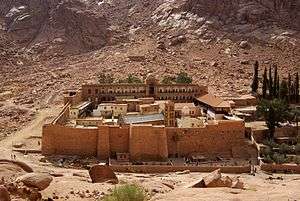 |
South Sinai Governorate, 28°33′22″N 33°58′32″E |
Cultural: (i)(iii)(iv)(vi) |
60,100 (149,000) | 2002 | The orthodox monastery of Saint Catherine is among the oldest Christian monasteries still in function. Dating from the 6th century, it is positioned near Mount Horeb where, according to the Old Testament, Moses received the Tablets of the Law. The region is sacred for Christians, Muslims and Jews.[16] |
| Wadi Al-Hitan (Whale Valley) |  |
Faiyum Governorate, 29°20′00″N 30°11′00″E |
Natural: (viii) |
20,015 (49,460) | 2005 | Located in western Egypt, Wadi Al-Hitan contains fossil remains of the now extinct Archaeoceti, mapping the evolution of the whales from a land-based to an aquatic mammal.[17] |
| The Ahwar of Southern Iraq: Refuge of Biodiversity and the Relict Landscape of the Mesopotamian Cities | 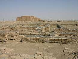 |
31°33′44″N 47°39′28″E |
Mixed: (iii)(v)(ix)(x) |
211,544 (522,740) | 2016 | Located in southern Iraq, the site contains three cities of Sumerian origin, namely Uruk, Ur and Eridu, in addition to four wetland areas in the Iraqi Marshlands.[18] |
| Babylon | 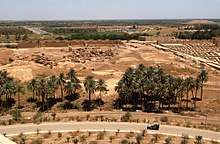 |
Babil Governorate, 32°32′31.09″N 44°25′15″E |
Cultural: (iii)(vi) |
1,054.3 (2,605) | 2019 | [19] |
| Erbil Citadel | 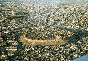 |
Arbil Governorate, 36°11′28″N 44°00′33″E |
Cultural: (iv) |
16 (40) | 2014 | Situated on the top of a tell in Iraqi and overlooking the city of Erbil, the Erbil Citadel constitutes a typical example of Ottoman-era urban-planning. In addition to its 19th century fortifications, the site also contains remains dating back to the Assyrian period.[20] |
| Ashur (Qal'at Sherqat) | .jpg) |
Salah ad Din Governorate, 35°27′32″N 43°15′35″E |
Cultural: (iii)(iv) |
70 (170) | 2003 | Located on the Tigris and dating from the 3rd millennium BCE, Ashur was the first capital of the Assyrian Empire and the religious centre of the Assyrians. Following its destruction by the Babylonians, the city was briefly revived during the Parthian period.[21] |
| Hatra | 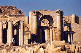 |
Ninawa Governorate, 35°35′17″N 42°43′06″E |
Cultural: (ii)(iii)(iv)(vi) |
324 (800) | 1985 | The fortified Parthian city of Hatra withstood repeated attacks by the Roman Empire in the 2nd century. Its architecture reflects both Hellenistic and Roman influences.[22] |
| Samarra Archaeological City | 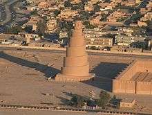 |
Salah ad Din Governorate, 34°20′28″N 43°49′25″E |
Cultural: (ii)(iii)(iv) |
15,058 (37,210) | 2007 | Located on the Tigris, the Islamic city of Samarra was the capital of the Abbasid Caliphate. It contains two of the largest mosques and several of the largest palaces in the Islamic world, in addition to being among the finest example of Abbasid-era town-planning.[23] |
| Baptism Site "Bethany Beyond the Jordan" (Al-Maghtas) | .JPG) |
31°50′14″N 35°33′10″E |
Cultural: (iii)(vi) |
294 (730) | 2015 | Situated on the Jordan River, Al-Maghtas is considered the location of the Baptism of Jesus by John the Baptist. A Christian pilgrimage site, it contains remains of Roman and Byzantine churches, chapels, a monastery, caves and pools.[24] |
| Petra | _-_Petra%2C_Jordan_-_14_Oct._2009.jpg) |
Ma'an Governorate, 30°19′50″N 35°26′36″E |
Cultural: (i)(iii)(iv) |
— | 1985 | The Nabataean city of Petra was a major trading hub between Arabia, Egypt and Syria-Phoenicia, famed for its rock-cut architecture as well as its mining and water engineering systems.[25] |
| Quseir Amra |  |
Zarqa Governorate, 31°48′7″N 36°35′9″E |
Cultural: (i)(iii)(iv) |
— | 1985 | The desert castle of Quseir Amra was built in the early 8th century, and had served both as a fortress and a Umayyad royal palace. The site also noted for its extensive frescoes, constituting an important and unique example of early Islamic art.[26] |
| Um er-Rasas (Kastrom Mefa'a) | 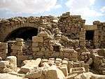 |
Madaba Governorate, 31°30′6″N 35°55′14″E |
Cultural: (i)(iv)(vi) |
24 (59) | 2005 | Established as a Roman military camp, Um er-Rasas grew into a settlement by the 5th century, inhabited successively by Christian and Islamic communities. The largely unexcavated site contains ruins of Roman fortifications, churches with well-preserved mosaic floors and two stylite towers.[27] |
| Wadi Rum Protected Area |  |
29°38′23″N 35°26′02″E |
Mixed: (iii)(v)(vii) |
74,180 (183,300) | 2005 | Situated in southern Jordan, Wadi Rum features a great variety of desert landforms including sandstone valleys, natural arches, gorges, cliffs, landslides and caverns. The site also contains extensive rock art, inscriptions and archaeological remains, bearing witness to more than 12,000 years of continuous human habitation.[28] |
| Anjar | 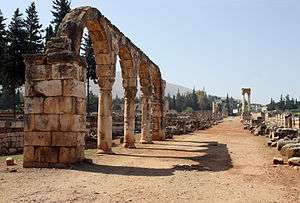 |
Beqaa Governorate, 33°43′33″N 35°55′47″E |
Cultural: (iii)(iv) |
— | 1984 | Established in the early 8th century, the city of Anjar was quickly abandoned following the fall of the Umayyad Caliphate, leaving behind ruins of walls, towers, palaces, mosques and baths, constituting an example of Umayyad period town-planning.[29] |
| Baalbek | 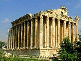 |
Baalbek-Hermel Governorate, 34°00′25″N 36°12′18″E |
Cultural: (i)(iv) |
— | 1984 | Previously known as Heliopolis, the Phoenician city of Baalbek hosts some of the largest and best preserved Roman temples, including the Temples of Jupiter, Venus and Bacchus.[30] |
| Byblos |  |
Mount Lebanon Governorate, 34°07′09″N 35°38′51″E |
Cultural: (iii)(iv)(vi) |
— | 1984 | Continuously inhabited since the Neolithic Era, Byblos was one of the oldest cities of Phoenician origin. It has since witness Persian, Roman, Crusader and Ottoman occupation, each exerting influence upon its architecture. Byblos also played a significant role in the diffusion of the Phoenician alphabet.[31] |
| Ouadi Qadisha (the Holy Valley) and the Forest of the Cedars of God (Horsh Arz el-Rab) |  |
North Lebanon Governorate, 34°14′36″N 36°02′56″E |
Cultural: (iii)(iv) |
— | 1998 | The Qadisha Valley has provided shelter for Christian communities since the beginnings of Christianity, hosting a large number of monasteries and hermitages. The Forest of the Cedars of God is among the last locations where Cedrus libani still grows, historically one of the most prized construction materials.[32] |
| Tyre | 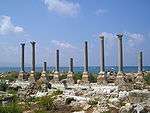 |
South Lebanon Governorate, 33°16′19″N 35°11′40″E |
Cultural: (iii)(vi) |
154 (380) | 1984 | The ancient Phoenician city of Tyre was one of the foremost maritime powers in the eastern Mediterranean and reportedly where purple dye was discovered. Extant archaeological remains mainly date back to Roman times, including baths, an arena, a colonnaded road, a triumphal arch, an aqueduct and a hippodrome.[33] |
| Archaeological Site of Cyrene | 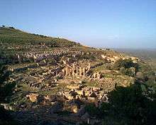 |
Jabal al Akhdar, 32°49′30″N 21°51′30″E |
Cultural: (ii)(iii)(vi) |
— | 1982 | The formerly Greek colony of Cyrene was Romanized and transformed into a capital, until it was destroyed by the 365 Crete earthquake. The thousand-year-old ruins have remained renowned since the 18th century.[34] |
| Archaeological Site of Leptis Magna | 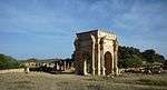 |
Khoms, 32°38′18″N 14°17′35″E |
Cultural: (i)(ii)(iii) |
— | 1982 | The Roman city of Leptis Magna was enlarged by Emperor Septimius Severus, who was born there. Public monuments, a harbour, a marketplace, storehouses, shops, and homes were among the reasons for its induction into the list.[35] |
| Archaeological Site of Sabratha | 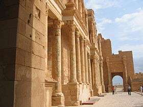 |
Zawiya District, 32°48′19″N 12°29′06″E |
Cultural: (iii) |
— | 1982 | Founded as a Phoenician trading post, Sabratha was briefly ruled by Masinissa of Numidia before its Romanization and reconstruction in the 2nd and 3rd centuries.[36] |
| Old Town of Ghadamès | 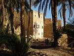 |
Nalut District, 30°08′00″N 9°30′00″E |
Cultural: (v) |
— | 1986 | Located in an oasis, Ghadames is among the oldest of pre-Saharan cities and represents a traditional domestic architecture with vertical division of functions.[37] |
| Rock-art sites of Tadrart Acacus | 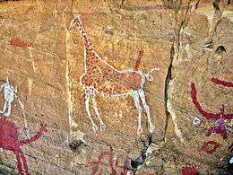 |
Fezzan, 24°50′00″N 10°20′00″E |
Cultural: (iii) |
— | 1985 | The massif of Tadrart Acacus contains thousands of cave paintings in different styles, dating from 12,000 BCE to 100 CE, reflecting changes of flora and fauna in the region as well as different lifestyles of successive populations in the Sahara.[38] |
| Ancient Ksour of Ouadane, Chinguetti, Tichitt and Oualata | 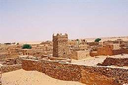 |
Ouadane, Chinguetti, Tichitt, and Oualata, 20°55′44″N 11°37′25″W |
Cultural: (iii)(iv)(v) |
— | 1996 | These four settlements were founded in the 11th and 12th centuries, originally meant to serve caravan trade routes across the Sahara. They gradually evolved into Islamic cultural centres, bearing witness to the nomadic lifestyle of the populations of western Sahara.[39] |
| Banc d'Arguin National Park |  |
Nouadhibou and Azefal, 20°14′05″N 16°06′32″W |
Natural: (ix)(x) |
1,200,000 (3,000,000) | 1989 | The park consists of sand dunes, coastal swamps, small islands, and shallow bodies of water; all bordering the coast of the Atlantic Ocean. Birds are often found to migrate in the area, accompanied by various species of sea turtles and dolphins, whose presence fishermen often use to attract fish.[40] |
| Archaeological site of Volubilis | 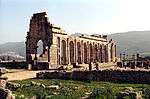 |
Fès-Meknès, 34°04′26″N 5°33′25″W |
Cultural: (ii)(iii)(iv)(vi) |
42 (100) | 1997 | The important Roman outpost of Volubilis was founded in the 3rd century BCE as the capital of Mauretania, later becoming the capital of the Idrisid dynasty. It contained many buildings, the remains of which have survived extensively to this day.[41] |
| Historic City of Meknes | 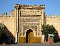 |
Fès-Meknès, 33°53′00″N 5°33′30″W |
Cultural: (iv) |
— | 1996 | The former capital of the Alaouite dynasty was founded in the 11th century by the Almoravids and turned into a city with Spanish-Moorish influence during the 17th and 18th centuries.[42] |
| Ksar of Ait-Ben-Haddou | 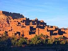 |
Drâa-Tafilalet, 31°02′50″N 7°07′44″W |
Cultural: (iv)(v) |
3 (7.4) | 1987 | The Ksar of Ait-Ben-Haddou is an example of a traditional pre-Saharan habitat in southern Morocco, surrounded by high walls and reinforced with corner towers.[43] |
| Medina of Essaouira (formerly Mogador) | 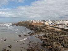 |
Marrakesh-Safi, 31°31′00″N 9°46′10″W |
Cultural: (ii)(iv) |
30 (74) | 2001 | Built during the late 18th century, the fortified seaport of Essaouira has a mix of North African and European architecture, and was a major trading hub between the Sahara and Europe.[44] |
| Medina of Fez |  |
Fez, 34°03′40″N 4°58′40″W |
Cultural: (ii)(v) |
280 (690) | 1981 | Fez was founded in the 9th century and reached its apogee as the capital of the Marinid dynasty in the 13th and 14th centuries, from which its urban fabric and major monuments date. It also hosts the world's oldest university, the University of Al Quaraouiyine.[45] |
| Medina of Marrakesh | 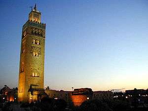 |
Marrakesh-Safi, 31°37′53″N 7°59′12″W |
Cultural: (i)(ii)(iv)(v) |
1,107 (2,740) | 1985 | Marrakesh was founded in the 1070s and remained a political, economic, and cultural centre for a long time. Monuments from that period include the Koutoubia Mosque, the kasbah, and the battlements. The city also holds newer features, including palaces and madrasas.[46] |
| Medina of Tétouan (formerly known as Titawin) | 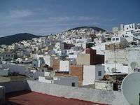 |
Tanger-Tetouan-Al Hoceima, 35°34′15″N 5°22′00″W |
Cultural: (ii)(iv)(v) |
7 (17) | 1997 | Morocco's most complete medina at Tétouan served as the main point of contact between Morocco and Andalusia during the 8th century. The town was rebuilt by Andalusian refugees following the Reconquista, the influence of which is evident in its art and architecture.[47] |
| Rabat, Modern Capital and Historic City: a Shared Heritage | 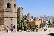 |
Rabat, 34°01′27″N 6°49′22″W |
Cultural: (ii)(iv) |
349 (860) | 2012 | Rebuilt under the direction of the French from 1912 to the 1930s, Rabat blends historic and modern features, such as botanical gardens, the Hassan Mosque, and the remnants of Moorish and Andalusian settlements from the 17th century.[48] |
| Portuguese City of Mazagan (El Jadida) |  |
Casablanca-Settat, 33°15′24″N 8°30′07″W |
Cultural: (ii)(iv) |
8 (20) | 2004 | The Portuguese fortification of Mazagan, akin to early Renaissance military design from the early 16th century, was taken over by Morocco in 1769. Surviving buildings include the cistern and a Gothic church.[49] |
| Aflaj Irrigation Systems of Oman | .jpg) |
Dakhiliyah, Sharqiyah and Batinah Regions, 22°59′56″N 57°32′10″E |
Cultural: (v) |
1,456 (3,600) | 2006 | The five Aflaj systems inscribed represents an irrigation method dating back to at least 500 CE. Such system effectively distribute water through gravity, as it flows to support agricultural and domestic use.[50] |
| Ancient City of Qalhat |  |
Ash Sharqiyah South Governorate, 22°42′N 59°22′E |
Cultural: (ii)(iii) |
75.82 (187.4) | 2018 | [51] |
| Archaeological Sites of Bat, Al-Khutm and Al-Ayn | 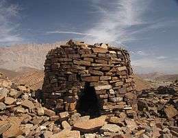 |
Ad Dhahirah Region, 23°16′11″N 56°44′42″E |
Cultural: (iii)(iv) |
— | 1988 | Located in the interior of the Sultanate, Bat, al-Khutm and al-Ayn are among the best preserved ensembles of settlements and necropolises from the 3rd millennium BCE in Eastern Arabia and the world. The necropolis of Bat, in particular, reflects the funeral practices of the Early Bronze Age in Oman.[52] |
| Bahla Fort |  |
Ad Dakhiliyah Region, 22°57′51″N 57°18′04″E |
Cultural: (iv) |
— | 1987 | The fort is part of Bahla, an oasis settlement and formerly the capital of the Nabhani dynasty, who dominated Oman and prospered in the Arabian Peninsula during the Late Middle Ages.[53] |
| Land of Frankincense | 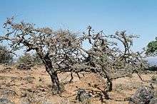 |
Dhofar Governorate, 18°15′12″N 53°38′51″E |
Cultural: (iii)(iv) |
850 (2,100) | 2000 | The ancient ports of Khor Rori and Al-Baleed, the caravan oasis of Shisr and Wadi Dawkah in southern Arabia were crucial in the production and distribution of frankincense, one of the most sought-after items of luxury in Antiquity.[54] |
| Old City of Jerusalem and its Walls | .jpg) |
East Jerusalem 31°46′00″N 35°13′00″E |
Cultural: (ii)(iii)(vi) |
— | 1981 | A holy city for three of the world's major religions, Jerusalem contains more than 200 historic monuments, including the Dome of the Rock, the Wailing Wall and the Church of the Holy Sepulchre.[55] |
| Birthplace of Jesus: Church of the Nativity and the Pilgrimage Route, Bethlehem | 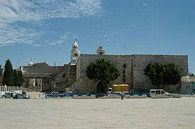 |
Bethlehem Governorate, 31°42′16″N 35°12′27″E |
Cultural: (ii)(iii) |
3 (7.4) | 2012 | The site is traditionally identified as the birthplace of Jesus. The church, built in the 4th century and reconstructed in the 6th century, holds prominent religious significance to both Christians and Muslims.[56][57] |
| Palestine: Land of Olives and Vines — Cultural Landscape of Southern Jerusalem, Battir |  |
Bethlehem Governorate, 31°43′11″N 35°07′50″E |
Cultural: (iv)(v) |
349 (860) | 2014 | The hill landscape of Battir features stone terraces for market garden, grapevine and olive production, supported by a traditional irrigation system.[58] |
| Hebron/Al-Khalil Old Town | -Mosche.JPG) |
Hebron Governorate, 31°31′30″N 35°06′30″E |
Cultural: (ii)(iv)(vi) |
20.6 (51) | 2017 | The centre of interest of the town was the site of Al mosque -Ibrahim / the tomb of the Patriarchs whose buildings are in a compound built in the 1st century CE to protect the tombs of the patriarch Abraham / Ibrahim and his family.[59] |
| Al Zubarah Archaeological Site | 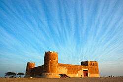 |
Al Shamal, 25°58′41″N 51°01′47″E |
Cultural: (iii)(iv)(v) |
416 (1,030) | 2013 | The coastal town of Al Zubarah was a major pearling and trading centre in the Persian Gulf in the late 18th and early 19th centuries, before its destruction in 1811 and eventual abandonment in the early 20th century. The remains of its palaces, mosques, harbour, fortifications and other structures are preserved by the sand blown from the desert.[60] |
| Al-Hasa | .jpg) |
Hofuf, Al-Ahsa Governorate 25°25′46″N 49°37′19″E |
Cultural: (iii)(iv)(v) |
8,544 (21,110) | 2018 | [61] |
| Al-Hijr Archaeological Site (Madâin Sâlih) | .jpg) |
Al Madinah Province, 26°47′01″N 37°57′18″E |
Cultural: (ii)(iii) |
1,621 (4,010) | 2008 | Formerly known as Hegra, the site of Al-Hijr constitutes the largest settlement of the Nabataean Kingdom after Petra. It contains a series of well-preserved rock-cut tombs and monuments dating back to the 1st century BCE.[62] |
| At-Turaif District in ad-Dir'iyah | 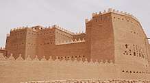 |
Riyadh Province, 24°44′03″N 46°34′21″E |
Cultural: (ii)(iii) |
29 (72) | 2008 | Founded in the 15th century, the Turaif District of Dir'iyah was the first capital of the Saudi dynasty. Dir'iyah witnessed the growth of its political and religious significance, as well as the spread of Wahhabism in the 18th and the early 19th centuries.[63] |
| Historic Jeddah, the Gate to Makkah |  |
Makkah Region, 21°29′02″N 39°11′15″E |
Cultural: (ii)(iv)(vi) |
18 (44) | 2014 | Located on the coast of the Red Sea, Jeddah grew into a major commercial centre in the 7th century, and has long served as the principal gateway for pilgrims to Mecca.[64] |
| Rock Art in the Ha'il Region | Ha'il Region, 28°00′38″N 40°54′47″E |
Cultural: (i)(iii) |
2,044 (5,050) | 2015 | The sites of Jabel Umm Sinman and Jabal al-Manjor and Raat contain a large number of petroglyphs and inscriptions, covering 10,000 years of human history.[65] | |
| Archaeological Sites of the Island of Meroe | 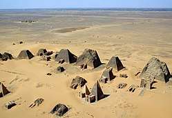 |
River Nile State, 16°56′00″N 33°43′00″E |
Cultural: (ii)(iii)(iv)(v) |
2,357 (5,820) | 2011 | Meroe was the centre of the Kingdom of Kush, a major force active from the 8th century BCE to the 4th century CE. It is home to pyramids, temples, and domestic buildings, among other vestiges.[66] |
| Gebel Barkal and the Sites of the Napatan Region | 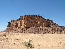 |
Northern State, 18°32′00″N 31°49′00″E |
Cultural: (i)(ii)(iii)(iv)(vi) |
183 (450) | 2003 | The archaeological sites of Gebel Barkal, Kurru, Nuri, Sanam and Zuma in the Nile Valley testify to the Napatan and Meroitic civilisations. They host a series of pyramids, tombs, temples, palaces, burial mounds and funerary chambers.[67] |
| Sanganeb Marine National Park and Dungonab Bay – Mukkawar Island Marine National Park | 19°44′10″N 37°26′35″E |
Natural: (vii)(ix)(x) |
199,524 (493,030) | 2016 | Situated in the central Red Sea, Sanganeb, Dungonab Bay and Mukkawar Island feature a diverse system of coral reefs, mangroves, seagrass beds, beaches and islets, and host populations of seabirds, marine mammals, fish, sharks, turtles, manta rays and dugongs.[68] | |
| Ancient City of Aleppo |  |
Aleppo Governorate, 36°14′00″N 37°10′00″E |
Cultural: (iii)(iv) |
350 (860) | 1986 | Situated at the crossroads of several trade routes, Aleppo has been successively ruled, among others, by the Romans, Ayyubids, Mameluks and Ottomans, each leaving significant influence in its architectural fabric, resulting in a diverse cityscape. Major structures include the Citadel, the Great Mosque and the Madrasa Halawiye.[69] |
| Ancient City of Bosra | 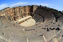 |
Daraa Governorate, 32°31′05″N 36°28′54″E |
Cultural: (i)(iii)(vi) |
— | 1980 | Formerly a Nabataean settlement, Bosra was conquered by the Romans in the 2nd century CE and made capital of Arabia. It came under Islamic rule in the 7th century. Remains of the ancient city include a theatre, a basilica, a cathedral, a mosque and a madrasa, among others.[70] |
| Ancient City of Damascus | 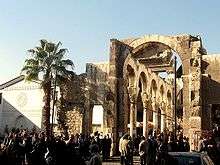 |
Damascus Governorate, 33°30′41″N 36°18′23″E |
Cultural: (i)(ii)(iii)(iv)(vi) |
86 (210) | 1979 | Established the 3rd millennium BCE, Damascus is considered to be one of the oldest continuously inhabited cities in the world. As the capital of the Umayyads, it has been of significant influence to the Arab world. The Great Mosque is among the largest in the world and the oldest sites of continuous prayer since the beginnings of Islam.[71] |
| Ancient Villages of Northern Syria | 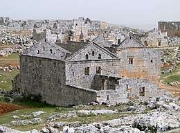 |
36°20′03″N 36°50′39″E |
Cultural: (iii)(iv)(v) |
12,290 (30,400) | 2011 | The site comprises some 40 villages, dating from the 1st to 7th centuries and abandoned in the 8th to 10th centuries. They provide an insight into rural life in Late Antiquity and during the Byzantine period.[72] |
| Crac des Chevaliers and Qal'at Salah El-Din | 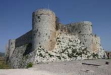 |
Homs and Latakia Governorates, 34°46′54″N 36°15′47″E |
Cultural: (ii)(iv) |
9 (22) | 2006 | The Crac des Chevaliers and the Qal'at Salah El-Din are regarded as two of the most prominent examples of castles during the Crusader period, demonstrating an evolution of fortifications and exchange of influences in defensive technology.[73] |
| Site of Palmyra |  |
Homs Governorate, 34°33′15″N 38°16′00″E |
Cultural: (i)(ii)(iv) |
0.36 (0.89) | 1980 | Palmyra came under Roman rule in the 1st century CE, and grew to become one of the most important cultural centres of the ancient world. Its extensive ruins include remains of the Great Colonnade, the Temple of Bel, the Camp of Diocletian and the Roman Theatre.[74] |
| Archaeological Site of Carthage |  |
Tunis Governorate, 36°51′10″N 10°19′24″E |
Cultural: (ii)(iii)(vi) |
616 (1,520) | 1979 | Founded in the 9th century BCE, Carthage developed into a trading empire spanning the Mediterranean. The city was destroyed in 146 BCE in the Punic Wars at the hands of the Romans, but was later reestablished.[75] |
| Dougga / Thugga |  |
Béja Governorate, 36°25′25″N 9°13′13″E |
Cultural: (ii)(iii) |
70 (170) | 1997 | The site features the ruins of Dougga, a former capital of a Libyan–Punic state, which flourished under the Romans and the Byzantines, but went into decline in the Islamic period.[76] |
| Amphitheatre of El Jem | 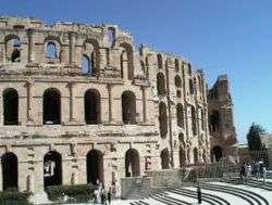 |
Mahdia Governorate, 35°17′47″N 10°42′25″E |
Cultural: (iv)(vi) |
1.37 (3.4) | 1979 | Built during the 3rd century, the Amphitheatre of El Jem is North Africa's largest amphitheatre, and the largest one built outside of Italy, with a capacity of 35,000 spectators, regarded as among the most accomplished examples of Roman architecture of its kind.[77] |
| Ichkeul National Park | 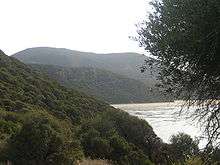 |
Bizerte Governorate, 37°09′49″N 9°40′29″E |
Natural: (x) |
12,600 (31,000) | 1980 | Ichkeul Lake and the surrounding wetlands is a destination for hundreds of thousands of migrating birds, including ducks, geese, storks and pink flamingos. It was once part of a chain that extended across North Africa.[78] |
| Kairouan |  |
Kairouan Governorate, 35°40′54″N 10°06′14″E |
Cultural: (i)(ii)(iii)(v)(vi) |
68 (170) | 1988 | Founded in 670, Kairouan was the former capital of Ifriqiya and flourished in the 9th century. Its heritage includes the Mosque of Uqba and the Mosque of the Three Gates.[79] |
| Medina of Sousse | 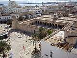 |
Sousse Governorate, 35°49′40″N 10°38′19″E |
Cultural: (iii)(iv)(v) |
32 (79) | 1988 | A prime example of a town from the early Islamic period, Sousse was an important commercial and military port during the 9th century.[80] |
| Medina of Tunis |  |
Tunis Governorate, 36°49′00″N 10°10′00″E |
Cultural: (ii)(iii)(v) |
296 (730) | 1979 | The Medina of Tunis contains some 700 monuments, including palaces, mosques, mausoleums, madrasah and fourtains, testifying to Tunis' golden age from the 12th to the 16th century.[81] |
| Punic Town of Kerkuane and its Necropolis | 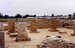 |
Nabeul Governorate, 36°56′47″N 11°05′57″E |
Cultural: (iii) |
— | 1985 | Abandoned in 250 BCE during the First Punic War and never rebuilt, Kerkuane is the only surviving example of a Phoenicio–Punic settlement.[82] |
| Cultural Sites of Al Ain (Hafit, Hili, Bidaa Bint Saud and Oases Areas) | 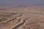 |
Abu Dhabi, 24°04′04″N 55°48′23″E |
Cultural: (iii)(iv)(v) |
4,945 (12,220) | 2011 | Situated in a desert region, Al Ain has been occupied since the Neolithic period, hosting stone tombs from the 3rd millennium BCE, wells, adobe constructions and one of the oldest examples of the aflaj irrigation system at Bidaa Bint Saud.[83] |
| Historic Town of Zabid |  |
Al Hudaydah Governorate, 14°11′53″N 43°19′48″E |
Cultural: (iii) |
— | 1993 | Zabid was the capital of Yemen from the 13th to the 15th century. Its Islamic university greatly contributed to the spread of Islamic knowledge.[84] |
| Old City of Sana'a | 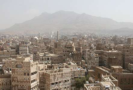 |
Sana'a Governorate, 15°21′20″N 44°12′29″E |
Cultural: (iv)(v)(vi) |
— | 1986 | Situated in a mountain valley, Sana'a has been continuously inhabited for more than 2,500 years. It became a centre for the spread of Islam in the 7th and 8th centuries. The city is home to the unique rammed-earth tower-houses, in addition to 103 mosques and 14 hammams built before the 11th century.[85] |
| Old Walled City of Shibam | 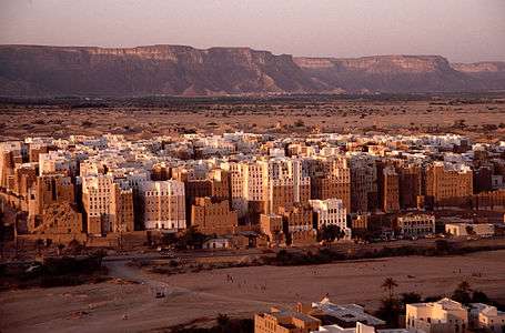 |
Hadhramaut Governorate, 15°55′37″N 48°37′36″E |
Cultural: (iii)(iv)(v) |
— | 1982 | The 16th-century walled city of Shibam is among the oldest and best examples of vertical urban planning, with its distinct mud brick tower houses garnering it the nickname "the Manhattan of the desert".[86] |
| Socotra Archipelago |  |
Socotra Governorate, 12°30′00″N 53°50′00″E |
Natural: (x) |
410,460 (1,014,300) | 2008 | Although part of the African landmass, the Socotra Archipelago is administered from Yemen. It is known for its great biodiversity and distinct flora and fauna, with a large number of endemic species found nowhere else on earth. It also supports a broad range of avian and marine life.[87] |
See also
References
- World Heritage Centre - World Heritage List
- "Djémila". UNESCO. Retrieved 17 August 2011.
- "Kasbah of Algiers". UNESCO. Retrieved 17 August 2011.
- "M'zab Valley". UNESCO. Retrieved 17 August 2011.
- "Tassili n'Ajjer". UNESCO. Retrieved 17 August 2011.
- "Timgad". UNESCO. Retrieved 17 August 2011.
- "Tipaza". UNESCO. Retrieved 17 August 2011.
- "Dilmun Burial Mounds". UNESCO. Retrieved 9 July 2019.
- "Qal'at al-Bahrain – Ancient Harbour and Capital of Dilmun". UNESCO. Retrieved 17 August 2011.
- "Pearling, Testimony of an Island Economy". UNESCO. Retrieved 1 July 2012.
- "Abu Mena". UNESCO. Retrieved 17 August 2011.
- "Ancient Thebes with its Necropolis". UNESCO. Retrieved 17 August 2011.
- "Historic Cairo". UNESCO. Retrieved 17 August 2011.
- "Memphis and its Necropolis – the Pyramid Fields from Giza to Dahshur". UNESCO. Retrieved 24 December 2016.
- "Nubian Monuments from Abu Simbel to Philae". UNESCO. Retrieved 17 August 2011.
- "Saint Catherine Area". UNESCO. Retrieved 17 August 2011.
- "Wadi Al-Hitan (Whale Valley)". UNESCO. Retrieved 17 August 2011.
- "The Ahwar of Southern Iraq: Refuge of Biodiversity and the Relict Landscape of the Mesopotamian Cities". UNESCO. Retrieved 6 August 2016.
- "Babylon". UNESCO. Retrieved 9 July 2019.
- "Erbil Citadel". UNESCO. Retrieved 2 January 2015.
- "Ashur (Qal'at Sherqat)". UNESCO. Retrieved 17 August 2011.
- "Hatra". UNESCO. Retrieved 17 August 2011.
- "Samarra Archaeological City". UNESCO. Retrieved 17 August 2011.
- "Baptism Site "Bethany Beyond the Jordan" (Al-Maghtas)". UNESCO. Retrieved 6 October 2015.
- "Petra". UNESCO. Retrieved 17 August 2011.
- "Qasr Amra". UNESCO. Retrieved 17 August 2011.
- "Um er-Rasas (Kastrom Mefa'a)". UNESCO. Retrieved 17 August 2011.
- "Wadi Rum Protected Area". UNESCO. Retrieved 17 August 2011.
- "Anjar". UNESCO. Retrieved 17 August 2011.
- "Baalbek". UNESCO. Retrieved 17 August 2011.
- "Byblos". UNESCO. Retrieved 17 August 2011.
- "Ouadi Qadisha (the Holy Valley) and the Forest of the Cedars of God (Horsh Arz el-Rab)". UNESCO. Retrieved 17 August 2011.
- "Tyre". UNESCO. Retrieved 17 August 2011.
- "Archaeological Site of Cyrene". UNESCO. Retrieved 17 August 2011.
- "Archaeological Site of Leptis Magna". UNESCO. Retrieved 17 August 2011.
- "Archaeological Site of Sabratha". UNESCO. Retrieved 17 August 2011.
- "Old Town of Ghadamès". UNESCO. Retrieved 17 August 2011.
- "Rock-Art Sites of Tadrart Acacus". UNESCO. Retrieved 17 August 2011.
- "Ancient Ksour of Ouadane, Chinguetti, Tichitt and Oualata". UNESCO. Retrieved 17 August 2011.
- "Banc d'Arguin National Park". UNESCO. Retrieved 17 August 2011.
- "Archaeological Site of Volubilis". UNESCO. Retrieved 17 August 2011.
- "Historic City of Meknes". UNESCO. Retrieved 17 August 2011.
- "Ksar of Ait-Ben-Haddou". UNESCO. Retrieved 17 August 2011.
- "Medina of Essaouira (formerly Mogador)". UNESCO. Retrieved 17 August 2011.
- "Medina of Fez". UNESCO. Retrieved 17 August 2011.
- "Medina of Marrakesh". UNESCO. Retrieved 17 August 2011.
- "Medina of Tétouan (formerly known as Titawin)". UNESCO. Retrieved 17 August 2011.
- "Rabat, Modern Capital and Historic City: a Shared Heritage". UNESCO. Retrieved 6 February 2016.
- "Portuguese City of Mazagan (El Jadida)". UNESCO. Retrieved 17 August 2011.
- "Aflaj Irrigation Systems of Oman". UNESCO. Retrieved 17 August 2011.
- "Ancient City of Qalhat". UNESCO. Retrieved 29 June 2018.
- "Archaeological Sites of Bat, Al-Khutm and Al-Ayn". UNESCO. Retrieved 17 August 2011.
- "Bahla Fort". UNESCO. Retrieved 17 August 2011.
- "Land of Frankincense". UNESCO. Retrieved 17 August 2011.
- "Old City of Jerusalem and its Walls". UNESCO. Retrieved 17 August 2011.
- "Birthplace of Jesus: Church of the Nativity and the Pilgrimage Route, Bethlehem". UNESCO. Retrieved 12 May 2016.
- "The site of the Birthplace of Jesus in Bethlehem (Palestine) removed from the List of World Heritage in Danger". UNESCO. Retrieved 7 July 2019.
- "Palestine: Land of Olives and Vines – Cultural Landscape of Southern Jerusalem, Battir". UNESCO. Retrieved 12 May 2016.
- "Hebron/Al-Khalil Old Town - UNESCO World Heritage Centre". Unesco. Retrieved 7 July 2017.
- "Al Zubarah Archaeological Site". UNESCO. Retrieved 3 May 2015.
- "Al-Ahsa Oasis, an Evolving Cultural Landscape". UNESCO. Retrieved 29 June 2018.
- "Al-Hijr Archaeological Site (Madâin Sâlih)". UNESCO. Retrieved 17 August 2011.
- "At-Turaif District in ad-Dir'iyah". UNESCO. Retrieved 17 August 2011.
- "Historic Jeddah, the Gate to Makkah". UNESCO. Retrieved 12 October 2015.
- "Rock Art in the Hail Region of Saudi Arabia". UNESCO. Retrieved 12 October 2015.
- "Archaeological Sites of the Island of Meroe". UNESCO. Retrieved 17 August 2011.
- "Gebel Barkal and the Sites of the Napatan Region". UNESCO. Retrieved 17 August 2011.
- "Sanganeb Marine National Park and Dungonab Bay – Mukkawar Island Marine National Park". UNESCO. Retrieved 6 August 2016.
- "Ancient City of Aleppo". UNESCO. Retrieved 17 August 2011.
- "Ancient City of Bosra". UNESCO. Retrieved 17 August 2011.
- "Ancient City of Damascus". UNESCO. Retrieved 17 August 2011.
- "Ancient Villages of Northern Syria". UNESCO. Retrieved 17 August 2011.
- "Crac des Chevaliers and Qal'at Salah El-Din". UNESCO. Retrieved 17 August 2011.
- "Site of Palmyra". UNESCO. Retrieved 17 August 2011.
- "Archaeological Site of Carthage". UNESCO. Retrieved 17 August 2011.
- "Dougga / Thugga". UNESCO. Retrieved 17 August 2011.
- "Amphitheatre of El Jem". UNESCO. Retrieved 17 August 2011.
- "Ichkeul National Park". UNESCO. Retrieved 17 August 2011.
- "Kairouan". UNESCO. Retrieved 17 August 2011.
- "Medina of Sousse". UNESCO. Retrieved 17 August 2011.
- "Medina of Tunis". UNESCO. Retrieved 17 August 2011.
- "Punic Town of Kerkuane and its Necropolis". UNESCO. Retrieved 17 August 2011.
- "Cultural Sites of Al Ain (Hafit, Hili, Bidaa Bint Saud and Oases Areas)". UNESCO. Retrieved 6 February 2016.
- "Historic Town of Zabid". UNESCO. Retrieved 17 August 2011.
- "Old City of Sana'a". UNESCO. Retrieved 17 August 2011.
- "Old Walled City of Shibam". UNESCO. Retrieved 17 August 2011.
- "Socotra Archipelago". UNESCO. Retrieved 17 August 2011.
External links
- UNESCO World Heritage Centre – Official site
- List of UNESCO World Heritage Sites – Official site
- VRheritage.org – documentation of World Heritage Sites
- Worldheritage-Forum – Information and Weblog on World Heritage Issues
Lists of World Heritage Sites in Asia | ||
|---|---|---|
| Northern and Central Asia | ||
| Western Asia (including Arab States) | ||
| Eastern Asia | ||
| Southern Asia |
| |
| Southeast Asia | ||
| Locations | ||
|---|---|---|
| Related | ||
This article is issued from Wikipedia. The text is licensed under Creative Commons - Attribution - Sharealike. Additional terms may apply for the media files.