Aleppo Governorate
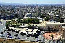
Aleppo Governorate (Arabic: محافظة حلب / ALA-LC: Muḥāfaẓat Ḥalab / [muˈħæːfazˤat ˈħælæb]) is one of the fourteen governorates of Syria. It is the most populous governorate in Syria with a population of more than 4,867,000 (2011 Est.), almost 23% of the total population of Syria. The governorate is the fifth in area with an area of 18,482 km2 (7,136 sq mi),[1] or 18,498 sq. km,[2] about 10% of the total area of Syria. The capital is the city of Aleppo.
Aleppo Governorate مُحافظة حلب | |
|---|---|
.svg.png) Map of Syria with Aleppo highlighted | |
| Coordinates (Aleppo): 36.2°N 37.6°E | |
| Country | |
| Capital | Aleppo |
| Manatiq (Districts) | 10 |
| Government | |
| • Governor | Hussein Diab |
| Area | |
| • Total | 18,482 km2 (7,136 sq mi) |
| Population (2011)(Pre-Civil War) | |
| • Total | 4,867,000 |
| • Density | 260/km2 (680/sq mi) |
| Time zone | UTC+2 (EET) |
| • Summer (DST) | UTC+3 (EEST) |
| ISO 3166 code | SY-HL |
| Main language(s) | Arabic Syriac Kurdish Turkish Armenian |
| Website | Aleppo Governorate |
Historically, Aleppo Governorate and the adjacent region has been one the most fertile and the most densely populated in Syria, hence why the Governorate has by far the largest number of towns (32 towns), villages (1,430 villages), and farms (1,424 farms) in Syria (compare to 28 towns, 190 villages, and 82 farms in Rif Dimashq Governorate).
History
Ancient
In Classical Antiquity, the region was made up of three regions: Chalybonitis (with its centre at Chalybon or Aleppo), Chalcidice (with its center at Qinnasrīn العيس), and Cyrrhestica (with its center at Cyrrhus النبي حوري). This was the most fertile and populated region in Syria. Under the Romans the region was made in 193 CE part of the province of Coele Syria or Magna Syria, which was ruled from Antioch. The province of Euphratensis was established in the 4th century CE in the east, its centre was Hierapolis Bambyce (Manbij).[3]
Under the Rashidun and Umayyad Muslim dynasties, the region was part of the Jund Qinnasrin.[4] In the Abbasid period the region was under the independent rule of the Hamdanids. The Mamluks and then later the Ottomans governed the area until 1918; under the Ottomans, the region was part of the Vilayet of Aleppo.[5]
Modern history
During the French Mandate the region was part of the short-lived State of Aleppo.[6]
Aleppo Governorate formerly included Idlib Governorate, until the latter was split off circa 1960.[2]
Syrian Civil War (2011-present)
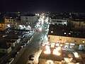
The governorate has been the scene of some of the fiercest fighting in the Syrian Civil War. In June 2017, nearly six years after the war's start, the province was almost equally divided between Syrian Government forces, Syrian Opposition forces, Turkish Army /TFSA and the Rojava/Syrian Democratic Forces. After fierce fighting, the Syrian Arab Army with Russian air support managed to take control of the capital of the Governorate, Aleppo, in December 2016 from Fatah Halab coalition.
In August 2016, the Turkish Army, backed by the Free Syrian Army launched the Operation Euphrates Shield in order to drive ISIL from the border towns of Jarablus, A'zaz and Al-Bab. The operation resulted in success and starting in May 2017, the region is now under Turkish occupation.[7][8] The Islamic State of Iraq and the Levant was largely removed from the area after the Syrian Arab Army launched the East Aleppo Offensive, the Maskanah Plains offensive, and the Southern Raqqa Offensive.
In January 2018, the Turkish army backed by the Free Syrian Army launched the Turkish military operation in Afrin against the YPG, which resulted in the capture of the city of Afrin and 70% of the Afrin region.[9]
Geography
The governorate has a 221-kilometre (137 mi) long northern boundary with the Kilis, Gaziantep, and Şanlıurfa provinces of Turkey. To the east lies Raqqa Governorate, to the south Ḥamā Governorate, and to the west Idlib Governorate and Turkey's Hatay Province.
The governorate lies on a plateau known as the Aleppo plateau. The eastern and northern boundaries of the governorate correspond roughly to the eastern and northern boundaries of the plateau, although the northeastern portion of the governorate crosses the Euphrates valley into the Jazīrah plateau. The southeastern end of the governorate is continuous with the arid steppe of the northern Syrian Desert. To the south lie the eastern plains of Hama, and to the southwest lie the northern plains of Idlib.
The average elevation of the terrain is 379 metres (1,243 ft). The surface gradually slopes down in north–south and west–east directions, undulating gently with an amplitude of 10–30 m for each wave. The lowlands are covered with combined Paleozoic and Mesozoic sediments that average 4–5 km in thickness over the whole surface.[10]
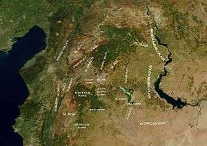
Starting from the valley of the Euphrates, the terrain rises forming the Manbij plain and then sinks again at the Dhahab river valley in the east of Aleppo Governorate. The Dhahab drains the highlands north of Bāb and runs in a north–south direction for about 50 km (31 mi) until it drains into Lake Jabboul. West of the Dhahab valley the terrain rises again forming Mount ʻAqīl (Mount Taymar) west of Bāb and Mount Ḥaṣṣ west of Lake Jabboul.[11] The terrain sinks again forming the valley of River Quwēq. The endpoint of Quwēq, the Maṭkh swamp (249 metres (817 ft)), is the lowest point in Aleppo Governorate. West of the Quwēq is Mount Simeon. South of Mount Simeon are the plains of Idlib. The River ʻAfrīn runs west of Mount Simeon. To the west of River ʻAfrīn the land rises again forming Mount Kurd. The highest point in the governorate, Mount Bulbul (1,269 metres (4,163 ft)), is located in the northern part of Mount Kurd. River ʻIfrīn runs from north to south between Mount Simeon and Mount Kurd and then turns west to the Orontes valley, thus separating Mount Kurd from Mount Ḥārim to the south.
The governorate is generally deforested except for a dispersed forest of about 50 square kilometres (19 sq mi) on the eastern slope of Mount Kurd where it faces the plain of Aʻzāz. The main trees are Aleppo Pine and oak.
Arable land makes up 66% of the total area in the governorate. The main crops are olives, figs, plums, pomegranates, vegetables, grains, rice, and pistachios. Pistachio is called in Syria fustuq Ḥalabī (Aleppo pistachio). Agriculture was traditionally supported by rivers; the main rivers in Aleppo are the Quwēq, ʻIfrīn, Sājūr, Dhahab, Aswad, and Euphrates. However, all of these rivers arise in Turkey, and due to irrigation projects on the Turkish side of the border the flow of these rivers dropped so much that most of them could no longer support agriculture. The Quwēq, for example, dried up completely in the 1950s. The vanishing of the rivers forced farmers to depend largely on rainfall and on water diverted from the Euphrates. A pumping station at Maskanah (95 km east of Aleppo) provides drinking water for Aleppo from the Euphrates. Recently Euphrates water has been diverted to revive the dead Qwēq river, and thus revive agriculture in the plains south of Aleppo. Urban areas, highlands, swamps, forests, and grazing land make up 34% of the total area of the governorate. The remaining 14% is a desert area in the southeast that is continuous with the Syrian Desert and known as the Aleppo Desert (Arabic: بادية حلب).
The largest lake in the governorate is Lake Jabboul, a Ramsar salt lake located 40 kilometres (25 mi) southeast of Aleppo. Lake Assad (the largest lake in Syria) separates Aleppo Governorate from Raqqa Governorate. Other artificial lakes include the Lake of 17 April on the River ʻIfrīn and the revived Shabāʼ Lake on River Quwēq.
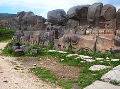
Archaeological sites are abundant in the governorate, especially at Mount Simeon in the west and the plains that extend beyond towards Antioch and Idlib. This region, known as the Limestone Massif, has the largest concentration of Late Antiquity churches in the world, with a unique Syrian architectural style.[12] It also has the famous Dead Cities of Syria.[13]
Cities
The following cities are the administrative centres of the districts in Aleppo Governorate (Population based on 2004 official census):
| City | Population |
|---|---|
| Aleppo | 2,132,100[14] |
| Manbij | 99,497[15] |
| As Safirah | 63,708[16] |
| Al-Bab | 63,069[17] |
| Ayn Al-Arab | 44,821[18] |
| Afrin | 36,562[19] |
| A'zaz | 31,623[20] |
| Dayr Hafir | 18,948[21] |
| Jarabulus | 11,570[22] |
| Atarib | 10,657[23] |
Districts
The governorate has 10 districts (mintaqas) in 2011:
- Afrin District
- Atarib District
- Ayn al-Arab District
- Azaz District
- al-Bab District
- Dayr Hafir District
- Jarabulus District
- Manbij District
- Mount Simeon District (including Aleppo city)
- Safirah District
These districts are divided into 46 sub-districts (nawāḥī).
Climate
Aleppo Governorate has a semi-arid climate. The mountain series that run along the Mediterranean coast, namely Mount Alawites and Mount Amanus, largely block the effects of the Mediterranean on climate (rain shadow effect). The average temperature in the governorate is 15–20 °C (59–68 °F). The average precipitation ranges from 500 mm (20 in) in the western parts of the governorate to 200 mm (8 in) in the easternmost parts and 150 mm (6 in) in the southeastern desert. 80% of precipitation occurs between October and March. Snow is usually in winter. Average humidity is 60% in the west and 55% in the east.
DemographicsAs per the 2004 Syrian census the population was 4,045,200.[2] A 2011 UNOCHA estimate put the population at 4,867,900, though this has likely changed since the start of the war.[27] The people are mostly Arabs. Kurds and Turkmen are found mostly in the northern districts. The Kurds are found mostly in Afrīn and Ayn Al-Arab. The Turkmen live in about 140 villages, mostly in Akhtarin Subdistrict, Al-Rai Subdistrict. Ghandoura Subdistrict and Sawran Subdistrict. Armenians and Assyrian/Syriac Christians are found in the cities, along with some Yezidis. ReligionsA large majority of inhabitants are Sunni Muslim—Arabs, Kurds, and Circassians. The Christians form a large minority of about 10-12%. This includes Armenians, Assyrian/Syriac Christians, and the Arabic-speaking Levantines. Smaller communities of Shia Muslims, Alawites, and Yezidis are also found in some numbers in the province. The Shias are of the Imami and Ismaili varieties, residing chiefly in a number of villages to the west and southwest of Aleppo city. The Alawites and Christians live mostly in Aleppo city and northeast of the city. LanguagesThe primary languages of the province are Arabic and Kurdish. The Arabic dialect of Aleppo is a transitional dialect between Levantine and Jaziran Arabic. Bedouin influence is evident in the language and culture of the Arabs. The Kurdish speakers use the western variety of the Kurmanji dialect of Kurdish. Other languages such as Turkish, Neo-Aramaic, Armenian, and Circassian are also spoken in some number in Aleppo province. Gallery
References
| |||||||||||||||||||||||||||||||||||||||||||||||||||||||||||||||||||||||||||||||||||||||||||||||||||||||||||||||||||||||||||||||||||||||||||||||||||||||||||||||||||||||||||||||||||||||||||||||||||||||||||||||||||||||||||||||||||||||||||||||||||||||||||||||||||||||||||||||||||||||||||||||||||||||||||||||||||||||