Petra
Petra (Arabic: ٱلْبَتْرَاء, romanized: Al-Batrāʾ; Ancient Greek: Πέτρα, "Stone"), originally known to its inhabitants as Raqmu,[3] is a historical and archaeological city in southern Jordan. Petra lies around Jabal Al-Madbah in a basin surrounded by mountains which form the eastern flank of the Arabah valley that runs from the Dead Sea to the Gulf of Aqaba.[4] The area around Petra has been inhabited from as early as 7000 BC,[5] and the Nabataeans might have settled in what would become the capital city of their kingdom, as early as the 4th century BC.[6] However, archaeological work has only discovered evidence of Nabataean presence dating back to the second century BC,[7] by which time Petra had become their capital.[5] The Nabataeans were nomadic Arabs who invested in Petra's proximity to the trade routes by establishing it as a major regional trading hub.[5][8]
| Petra Raqmu | |
|---|---|
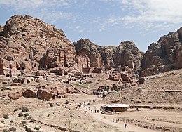 View of Petra | |
| Location | Ma'an Governorate, Jordan |
| Coordinates | 30°19′43″N 35°26′31″E |
| Area | 264 square kilometres (102 sq mi)[1] |
| Elevation | 810 m (2,657 ft) |
| Built | possibly as early as 5th century BC [2] |
| Visitors | 1,135,300 (in 2019) |
| Governing body | Petra Region Authority |
| Website | www.visitpetra.jo |
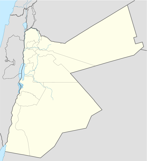 Location of Petra Raqmu in Jordan | |
| Criteria | Cultural: i, iii, iv |
| Reference | 326 |
| Inscription | 1985 (9th session) |
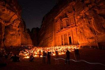
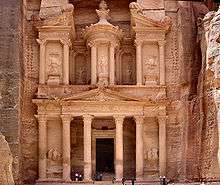
The trading business gained the Nabataeans considerable revenue and Petra became the focus of their wealth. The Nabataeans were accustomed to living in the barren deserts, unlike their enemies, and were able to repel attacks by taking advantage of the area's mountainous terrain. They were particularly skillful in harvesting rainwater, agriculture and stone carving. Petra flourished in the 1st century AD, when its famous Al-Khazneh structure – believed to be the mausoleum of Nabataean king Aretas IV – was constructed, and its population peaked at an estimated 20,000 inhabitants.[9]
Although the Nabataean kingdom became a client state of the Roman Empire in the first century BC, it was only in 106 AD that it lost its independence. Petra fell to the Romans, who annexed Nabataea and renamed it as Arabia Petraea. Petra's importance declined as sea trade routes emerged, and after an earthquake in 363 destroyed many structures. In the Byzantine era several Christian churches were built, but the city continued to decline, and by the early Islamic era it was abandoned except for a handful of nomads. It remained unknown to the world until it was rediscovered in 1812 by Johann Ludwig Burckhardt.[10]
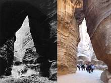
Access to the city is through a 1.2-kilometre-long (0.75 mi) gorge called the Siq, which leads directly to the Khazneh. Famous for its rock-cut architecture and water conduit system, Petra is also called the 'Rose City' because of the colour of the stone from which it is carved.[11] It has been a UNESCO World Heritage Site since 1985. UNESCO has described Petra as "one of the most precious cultural properties of man's cultural heritage".[12] In 2007, Al-Khazneh was voted one of the New7Wonders of the World. Petra is a symbol of Jordan, as well as Jordan's most-visited tourist attraction. Tourist numbers peaked at 918,000 in 2010, but there followed a temporary slump during the political instability generated by the Arab Spring, which affected countries surrounding Jordan.[13] Visitor numbers subsequently increased and reached a record-breaking 1.1 million tourists in 2019, marking the first time that the figure rose above the 1 million mark.[14] Tourism in the city was crippled by the COVID-19 pandemic as visitor numbers plummeted to zero since March 2020. The Jordanian government has authorized excavations in front of the treasury to make use of the site's emptiness.[15]
Importance in antiquity
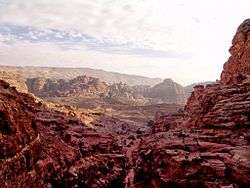
Pliny the Elder and other writers identify Petra as the capital of the Nabataean Kingdom and the centre of their caravan trade. Enclosed by towering rocks and watered by a perennial stream, Petra not only possessed the advantages of a fortress, but controlled the main commercial routes which passed through it to Gaza in the west, to Bosra and Damascus in the north, to Aqaba and Leuce Come on the Red Sea, and across the desert to the Persian Gulf.[4]
Description
Water control
Excavations have demonstrated that it was the ability of the Nabataeans to control the water supply that led to the rise of the desert city, creating an artificial oasis. The area is visited by flash floods, but archaeological evidence shows that the Nabataeans controlled these floods by the use of dams, cisterns and water conduits. These innovations stored water for prolonged periods of drought and enabled the city to prosper from its sale.[16][17]
Access routes
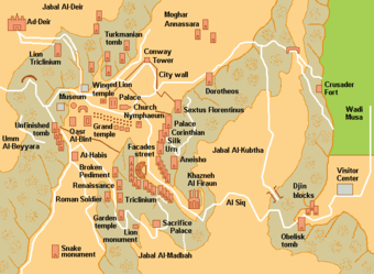
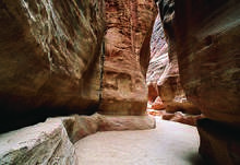
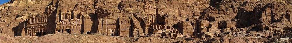
In ancient times, Petra might have been approached from the south on a track leading across the plain of Petra, around Jabal Haroun ("Aaron's Mountain"), the location of the Tomb of Aaron, said to be the burial place of Aaron, brother of Moses. Another approach was possibly from the high plateau to the north. Today, most modern visitors approach the site from the east. The impressive eastern entrance leads steeply down through a dark, narrow gorge, in places only 3–4 m (10–13 ft) wide, called the Siq ("shaft"), a natural geological feature formed from a deep split in the sandstone rocks and serving as a waterway flowing into Wadi Musa.[18]
City centre
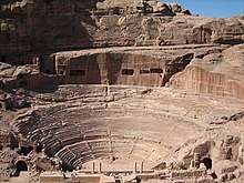
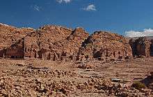
At the end of the narrow gorge, the Siq, stands Petra's most elaborate ruin, popularly known as Al-Khazneh ("the Treasury"), hewn into the sandstone cliff. While remaining in remarkably preserved condition, the face of the structure is marked by hundreds of bullet holes made by the local Bedouin tribes that hoped to dislodge riches that were once rumoured to be hidden within it.[18] A little further from the Treasury, at the foot of the mountain called en-Nejr, is a massive theatre, positioned so as to bring the greatest number of tombs within view. At the point where the valley opens out into the plain, the site of the city is revealed with striking effect. The theatre has been cut into the hillside and into several of the tombs during its construction. Rectangular gaps in the seating are still visible. Almost enclosing it on three sides are rose-coloured mountain walls, divided into groups by deep fissures and lined with knobs cut from the rock in the form of towers.[4]
The Petra Pool and Garden Complex is a series of structures within the city center. Originally said to be a market area,[19] excavations at the site have allowed scholars to identify it as an elaborate Nabataean garden, which included a large swimming pool, an island-pavilion, and an intricate hydraulic system.[20][21][22]
Huge structure discovered in 2016
In 2016, archaeologists using satellite imagery and drones discovered a very large, previously unknown monumental structure whose beginnings were tentatively dated to about 150 BCE, the time when the Nabataeans initiated their public building programme. It is located outside the main area of the city, at the foot of Jabal an-Nmayr and about 0.5 mi (0.80 km) south of the city centre, but is facing east, not towards the city, and has no visible relationship to it. The structure consists of a huge, 184 by 161 ft (56 by 49 m) platform, with a truly monumental staircase all along its eastern side. The large platform enclosed a slightly smaller one, topped with a comparatively small building, 28 by 28 ft (8.5 by 8.5 m), which was facing east toward the staircase. The structure, second in size only to the Monastery complex, probably had a ceremonial function of which not even a speculative explanation has yet been offered by the researchers.[23][24][25]
Climate
In Petra, there is a semi-arid climate. Most rain falls in the winter. The Köppen-Geiger climate classification is BSk. The average annual temperature in Petra is 15.5 °C (59.9 °F). About 193 mm (7.60 in) of precipitation falls annually.
| Climate data for Petra | |||||||||||||
|---|---|---|---|---|---|---|---|---|---|---|---|---|---|
| Month | Jan | Feb | Mar | Apr | May | Jun | Jul | Aug | Sep | Oct | Nov | Dec | Year |
| Average high °C (°F) | 11.0 (51.8) |
13.1 (55.6) |
16.6 (61.9) |
20.9 (69.6) |
25.1 (77.2) |
28.6 (83.5) |
29.8 (85.6) |
30.0 (86.0) |
28.1 (82.6) |
24.6 (76.3) |
18.2 (64.8) |
13.4 (56.1) |
21.6 (70.9) |
| Average low °C (°F) | 2.2 (36.0) |
2.8 (37.0) |
5.6 (42.1) |
8.7 (47.7) |
11.7 (53.1) |
14.1 (57.4) |
16.1 (61.0) |
16.5 (61.7) |
14.2 (57.6) |
11.2 (52.2) |
7.1 (44.8) |
3.4 (38.1) |
9.5 (49.1) |
| Average precipitation mm (inches) | 45 (1.8) |
38 (1.5) |
36 (1.4) |
12 (0.5) |
4 (0.2) |
0 (0) |
0 (0) |
0 (0) |
0 (0) |
2 (0.1) |
15 (0.6) |
41 (1.6) |
193 (7.6) |
| Source: Climate-Data.org,Climate data | |||||||||||||
History
Though the city was founded relatively late, a sanctuary has existed there since very ancient times.
Neolithic
By 7000 BCE, some of the earliest recorded farmers had settled in Beidha, a Pre-Pottery Neolithic settlement just north of Petra.[5]
Bronze Age
Petra is listed in Egyptian campaign accounts and the Amarna letters as Pel, Sela or Seir.
Iron Age Edom
The Edomite site excavated at the top of the Umm el-Biyara mountain at Petra was established not earlier than the seventh century BCE (Iron II).[26]
The emergence of Rekem/Petra
The Nabataeans were one among several nomadic Bedouin tribes that roamed the Arabian Desert and moved with their herds to wherever they could find pasture and water.[6] Although the Nabataeans were initially embedded in Aramaic culture, theories about them having Aramean roots are rejected by modern scholars. Instead, archaeological, religious and linguistic evidence confirm that they are a northern Arabian tribe.[27]
Petra as "Rekem"
Historian Josephus (ca. 37–100) writes that the region as inhabited by the Midianites during the time of Moses, and that they were ruled by five kings, one of whom was Rekem. Josephus mentions that the city, called Petra by the Greeks, "ranks highest in the land of the Arabs" and was still called Rekeme by all the Arabs of his time, after its royal founder (Antiquities iv. 7, 1; 4, 7).[28]
The name 'Rekem' was inscribed in the rock wall of the Wadi Musa opposite the entrance to the Siq.[29] However, Jordan built a bridge over the wadi and this inscription was buried beneath tons of concrete.[30]
Petra as "Sela"
An old theory held that Petra might be identified with a place called sela in the Hebrew Bible. Encyclopædia Britannica (1911) states that the Semitic name of the city, if not Sela, would remain unknown. It nevertheless cautioned that sela simply means "rock" in Hebrew, and thence might not be identified with a city where it occurs in the biblical text.[4]
The passage in Diodorus Siculus (xix. 94–97) which describes the expeditions which Antigonus sent against the Nabataeans in 312 BCE, was understood by some researchers – and not so by others – to throw some light upon the history of Petra, but the "petra" (Greek for rock) referred to as a natural fortress and place of refuge cannot be a proper name, and the description implies that there was no town in existence there at the time.[4][31]
Roman period
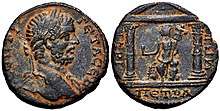
In AD 106, when Cornelius Palma was governor of Syria, the part of Arabia under the rule of Petra was absorbed into the Roman Empire as part of Arabia Petraea, and Petra became its capital.[32] The native dynasty came to an end but the city continued to flourish under Roman rule. It was around this time that the Petra Roman Road was built. A century later, in the time of Alexander Severus, when the city was at the height of its splendor, the issue of coinage came to an end. There was no more building of sumptuous tombs, owing apparently to some sudden catastrophe, such as an invasion by the neo-Persian power under the Sassanid Empire.[4]
Meanwhile, as Palmyra (fl. 130–270) grew in importance and attracted the Arabian trade away from Petra, the latter declined. It appears, however, to have lingered on as a religious centre. Another Roman road was constructed at the site. Epiphanius of Salamis (c.315–403) writes that in his time a feast was held there on December 25 in honour of the virgin Khaabou (Chaabou) and her offspring Dushara.[4] Dushara and al-Uzza were two of the main deities of the city, which otherwise included many idols from other Nabatean deities such as Allat and Manat.[33]
Between 111 and 114, Trajan built the Via Traiana Nova, running from the Syrian border to the Red Sea through Petra. This road followed the old routes of Nabataean caravans. In the shadow of the Pax Romana, this route revived trade between Arabia, Syria, and Mediterranean harbors. In 125 AD, one of Emperor Hadrian's administrators left marks in Petra, pointed out by documents found at the Dead Sea. In 130 AD, Hadrian visited the former Nabataean capital, giving it the name of Hadriane Petra Metropolis, imprinted on his coins. His visit, however, did not lead to any boom in architectural development and new buildings as it did in Jerash. The province's governor, Sextius Florentinus, erected a monumental mausoleum for his son near the end of the al-Hubta (King's Wall) tombs, which had been generally reserved during the Nabataean period for the royal family.
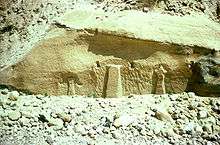
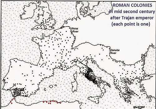
The interest that Roman emperors showed for the city in the 3rd century suggests that Petra and its environs remained highly esteemed for a long time. An inscription to Liber Pater, a god revered by Emperor Septimius Severus, was found in the temenos of the temple known as Qasr al-Bint, and Nabataean tombs contained silver coins with the Emperor's portrait, as well as pottery from his reign. Emperor Elagabalus declared Petra to be a Roman colony, when he reorganised the Roman Empire towards the end of the 3rd century.[34] The area from Petra to Wadi Mujib, the Negev, and the Sinai Peninsula were annexed into the province of Palaestina Salutaris. Petra may be seen on the Madaba mosaic map from the reign of Emperor Justinian.
.jpg)
Byzantine period
Petra declined rapidly under Roman rule, in large part from the revision of sea-based trade routes. In 363 an earthquake destroyed many buildings, and crippled the vital water management system.[35] The old city of Petra was the capital of the Byzantine province of Palaestina III and many churches were excavated in and around Petra from the Byzantine period. In one of them, the Byzantine Church, 140 papyri were discovered, which contained mainly contracts, dated from 537 to 593, establishing that the city was still flourishing in the sixth century.[36] The Byzantine Church is a prime example of monumental architecture in Byzantine Petra.
Crusaders and Mamluks
In the 12th century, the Crusaders built fortresses such as the Alwaeira Castle, but were forced to abandon Petra after a while. As a result, the location of Petra was lost for the Western world until the 19th century.[37][38]
Two further Crusader-period castles are known in and around Petra: the first is al-Wu'ayra, situated just north of Wadi Musa. It can be viewed from the road to Little Petra. It is the castle of Valle Moise which was seized by a band of Turks with the help of local Muslims and only recovered by the Crusaders after they began to destroy the olive trees of Wadi Musa. The potential loss of livelihood led the locals to negotiate surrender. The second is on the summit of el-Habis, in the heart of Petra, and can be accessed from the West side of the Qasr al-Bint.
The ruins of Petra were an object of curiosity during the Middle Ages and were visited by Baibars, one of the first Mamluk sultans of Egypt, towards the end of the 13th century.[4]
19th-20th centuries
The first European to describe them was Swiss traveller Johann Ludwig Burckhardt during his travels in 1812.[4][39] At that time, the Greek Church of Jerusalem operated a diocese in Al Karak named Battra (باطره in Arabic, and Πέτρας in Greek) and it was the opinion among the clergy of Jerusalem that Kerak was the ancient city of Petra.[39]
Léon de Laborde and Louis-Maurice-Adolphe Linant de Bellefonds made the first accurate drawings of Petra in 1828.[21] The Scottish painter David Roberts visited Petra in 1839 and returned to England with sketches and stories of the encounter with local tribes, published in The Holy Land, Syria, Idumea, Arabia, Egypt, and Nubia. Frederic Edwin Church, the leading American landscape painter of the 19th century, visited Petra in 1868, and the resulting painting El Khasné, Petra is among his most important and well-documented.[21]
Because the structures weakened with age, many of the tombs became vulnerable to thieves, and many treasures were stolen. In 1929, a four-person team, consisting of British archaeologists Agnes Conway and George Horsfield, Palestinian physician and folklore expert Dr Tawfiq Canaan and Dr Ditlef Nielsen, a Danish scholar, excavated and surveyed Petra.[40]
The archaeologist Philip Hammond from the University of Utah visited Petra for nearly 40 years. He explained that the local folklore says it was created by the wand of Moses, when he struck the rock to bring forth water for the Israelites. Hammond believed the carved channels deep within the walls and ground were made from ceramic pipes that once fed water for the city, from rock-cut systems on the canyon rim.[41]
Numerous scrolls in Greek and dating to the Byzantine period were discovered in an excavated church near the Temple of the Winged Lions in Petra in December 1993.[42]
Religion

The Nabataeans worshipped Arab gods and goddesses during the pre-Islamic era as well as a few of their deified kings. One, Obodas I, was deified after his death. Dushara was the primary male god accompanied by his three female deities: Al-‘Uzzá, Allat and Manāt. Many statues carved in the rock depict these gods and goddesses. New evidence indicates that broader Edomite, and Nabataean theology had strong links to Earth-Sun relationships, often manifested in the orientation of prominent Petra structures to equinox and solstice sunrises and sunsets.[43]
A stele dedicated to Qos-Allah 'Qos is Allah' or 'Qos the god', by Qosmilk (melech – king) is found at Petra (Glueck 516). Qos is identifiable with Kaush (Qaush) the God of the older Edomites. The stele is horned and the seal from the Edomite Tawilan near Petra identified with Kaush displays a star and crescent (Browning 28), both consistent with a moon deity. It is conceivable that the latter could have resulted from trade with Harran (Bartlett 194). There is continuing debate about the nature of Qos (qaus – bow) who has been identified both with a hunting bow (hunting god) and a rainbow (weather god) although the crescent above the stele is also a bow.
Nabatean inscriptions in Sinai and other places display widespread references to names including Allah, El and Allat (god and goddess), with regional references to al-Uzza, Baal and Manutu (Manat) (Negev 11). Allat is also found in Sinai in South Arabian language. Allah occurs particularly as Garm-'allahi – god decided (Greek Garamelos) and Aush-allahi – 'gods covenant' (Greek Ausallos). We find both Shalm-lahi 'Allah is peace' and Shalm-allat, 'the peace of the goddess'. We also find Amat-allahi 'she-servant of god' and Halaf-llahi 'the successor of Allah'.[44]
Recently, Petra has been put forward as the original 'Mecca' by some in the revisionist school of Islamic studies, owing to claims of large numbers of independent pieces of evidence, namely that the early original mosques faced Petra, not Jerusalem or Mecca, as the direction of Muslim prayer, the Qibla.[45] However, others have challenged the notion of comparing modern readings of Qiblah directions to early mosques’ Qiblahs as they claim early Muslims could not accurately calculate the direction of the Qiblah to Mecca and so the apparent pinpointing of Petra by some early mosques may well be coincidental.[46]
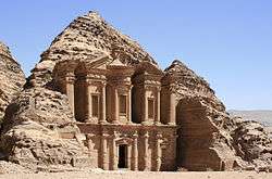
The Monastery, Petra's largest monument, dates from the 1st century BC. It was dedicated to Obodas I and is believed to be the symposium of Obodas the god. This information is inscribed on the ruins of the Monastery (the name is the translation of the Arabic Ad Deir).
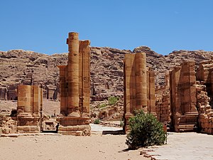
The Temple of the Winged Lions is a large temple complex dated to the reign of King Aretas IV (9 BCE–40 CE). The temple is located in Petra’s so-called Sacred Quarter, an area situated at the end of Petra’s main Colonnaded Street consisting of two majestic temples, the Qasr al-Bint and, opposite, the Temple of the Winged Lions on the northern bank of Wadi Musa.
Christianity found its way to Petra in the 4th century AD, nearly 500 years after the establishment of Petra as a trade centre. Athanasius mentions a bishop of Petra (Anhioch. 10) named Asterius. At least one of the tombs (the "tomb with the urn"?) was used as a church. An inscription in red paint records its consecration "in the time of the most holy bishop Jason" (447). After the Islamic conquest of 629–632, Christianity in Petra, as of most of Arabia, gave way to Islam. During the First Crusade Petra was occupied by Baldwin I of the Kingdom of Jerusalem and formed the second fief of the barony of Al Karak (in the lordship of Oultrejordain) with the title Château de la Valée de Moyse or Sela. It remained in the hands of the Franks until 1189.[4] It is still a titular see of the Catholic Church.[47]
According to Arab tradition, Petra is the spot where Musa (Moses) struck a rock with his staff and water came forth, and where Moses' brother, Harun (Aaron), is buried, at Mount Hor, known today as Jabal Haroun or Mount Aaron. The Wadi Musa or "Wadi of Moses" is the Arab name for the narrow valley at the head of which Petra is sited. A mountaintop shrine of Moses' sister Miriam was still shown to pilgrims at the time of Jerome in the 4th century, but its location has not been identified since.[48]
UNESCO listing of ancient Petra and Bedouin heritage
The Bidoul/Bidul (Petra Bedouin) were forcibly resettled from their cave dwellings in Petra to Umm Sayhoun/Um Seihun by the Jordanian government in 1985, prior to the UNESCO designation process. They were provided with block-built housing with some infrastructure including in particular a sewage and drainage system. Among the six communities in the Petra Region, Umm Sayhoun is one of the smaller communities. The village of Wadi Musa is the largest in the area, inhabited largely by the Layathnah Bedouin, and is now the closest settlement to the visitor centre, the main entrance via the Siq and the archaeological site generally. Umm Sayhoun gives access to the 'back route' into the site, the Wadi Turkmaniyeh pedestrian route.[49]
On December 6, 1985, Petra was designated a World Heritage Site. In a popular poll in 2007, it was also named one of the New7Wonders of the World. The Petra Archaeological Park (PAP) became an autonomous legal entity over the management of this site in August 2007.[50]
The Bidouls belong to one of the Bedouin tribes whose cultural heritage and traditional skills were proclaimed by UNESCO on the Intangible Cultural Heritage List in 2005 and inscribed[51] in 2008.
In 2011, following an 11-month project planning phase, the Petra Development and Tourism Region Authority in association with DesignWorkshop and JCP s.r.l published a Strategic Master Plan that guides planned development of the Petra Region. This is intended to guide planned development of the Petra Region in an efficient, balanced and sustainable way over the next 20 years for the benefit of the local population and of Jordan in general. As part of this, a Strategic Plan was developed for Umm Sayhoun and surrounding areas.[52]
The process of developing the Strategic Plan considered the area's needs from five points of view:
- a socio-economic perspective
- the perspective of Petra Archaeological Park
- the perspective of Petra's tourism product
- a land use perspective
- an environmental perspective
Issues
The site suffers from a host of threats, including collapse of ancient structures, erosion from flooding and improper rainwater drainage, weathering from salt upwelling,[53] improper restoration of ancient structures and unsustainable tourism.[54] The last has increased substantially, especially since the site received widespread media coverage in 2007 during the New7Wonders of the World Internet and cellphone campaign.[55]
In an attempt to reduce the impact of these threats, the Petra National Trust (PNT) was established in 1989. It has worked with numerous local and international organisations on projects that promote the protection, conservation, and preservation of the Petra site.[56] Moreover, UNESCO and ICOMOS recently collaborated to publish their first book on human and natural threats to the sensitive World Heritage sites. They chose Petra as its first and the most important example of threatened landscapes. The presentation Tourism and Archaeological Heritage Management at Petra: Driver to Development or Destruction? (2012) was the first in a series to address the very nature of these deteriorating buildings, cities, sites, and regions.[57] The next books in the series of deteriorating UNESCO World Heritage Sites will include Machu Picchu, Angkor Wat, and Pompeii.
People for the Ethical Treatment of Animals (PETA) released a video in 2018 highlighting abuse against working animals in Petra. PETA claimed that animals are forced to carry tourists or pull carriages every day. The video showed handlers beating and whipping working animals, with beatings intensifying when animals faltered. PETA also revealed some wounded animals, including camels with fly-infested, open wounds.[58] The Jordanian authority running the site responded by opening up a veterinarian clinic, and by spreading awareness among animal handlers.[59]
In popular culture
Literature
- Petra appeared in the novels Left Behind Series; Appointment with Death; The Eagle in the Sand; The Red Sea Sharks, the nineteenth book in The Adventures of Tintin series; and in Kingsbury's The Moon Goddess and the Son. It played a prominent role in the Marcus Didius Falco mystery novel Last Act in Palmyra. In Blue Balliett's novel, Chasing Vermeer, the character Petra Andalee is named after the site.[60]
- In 1979 Marguerite van Geldermalsen from New Zealand married Mohammed Abdullah, a Bedouin in Petra.[61] They lived in a cave in Petra until the death of her husband. She authored the book Married to a Bedouin. Van Geldermalsen is the only western woman who has ever lived in a Petra cave.
- An Englishwoman, Joan Ward, wrote Living With Arabs: Nine Years with the Petra Bedouin[62] documenting her experiences while living in Umm Sayhoun with the Petra Bedouin, covering the period 2004–2013.
Plays
- Playwright John Yarbrough's tragicomedy, Petra,[63] debuted at the Manhattan Repertory Theatre in 2014[64] and was followed by award-winning performances at the Hudson Guild in New York in 2015.[65] It was selected for the Best American Short Plays 2014-2015 anthology.[66]
Films
- The site appeared in films such as: Indiana Jones and the Last Crusade, Arabian Nights, Passion in the Desert, Mortal Kombat: Annihilation, Sinbad and the Eye of the Tiger, The Mummy Returns, Krrish 3, Transformers: Revenge of the Fallen, Samsara and Kajraare.[67]
Television
- Petra appeared in episode 20 of Misaeng.[68][69]
- Petra appeared in an episode of Time Scanners, made for National Geographic, where six ancient structures were laser scanned, with the results built into 3D models.[70] Examining the model of Petra revealed insights into how the structure was built.[71]
- Petra was the focus of an American PBS Nova special, "Petra: Lost City of Stone",[72] which premiered in the US and Europe in February 2015.
- Petra is central to Netflix's first Arabic original series Jinn, which is a young adult supernatural drama about magical genies in the ancient city of Petra. They must try and stop Jinn from destroying the world. The show is shot in Jordan and has five episodes.[73]
Music and musical videos
- Six months after a deadly hike by two Israelis in 1958, Haim Hefer wrote the lyrics for a ballad called Ha-Sela ha-Adom (“The Red Rock”)[74][75]
- In 1977, the Lebanese Rahbani brothers wrote the musical Petra as a response to the Lebanese Civil War.[76]
- The Sisters of Mercy filmed their music video for "Dominion/Mother Russia" in and around Al-Khazneh ("The Treasury") in February 1988.[77]
- In 1994 Petra appeared in the video to the Urban Species single "Spiritual Love".[78][79]
Gallery
.jpg) The Obelisk Tomb
The Obelisk Tomb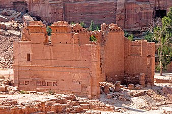
 The Hadrian Gate also known as the Temenos Gate
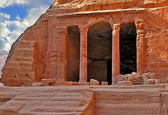 The Garden Temple
 The Colored Triclinium
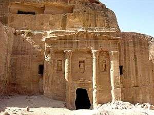
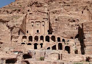 The Urn Tomb
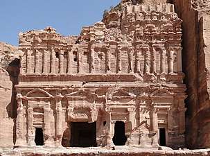 The Palace Tomb
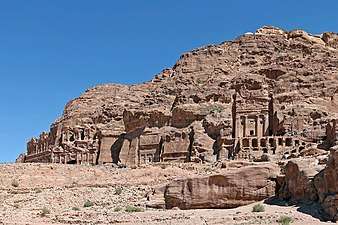 Rock graves
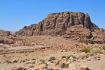 Petra Monastery Trail
.jpg) Street of Facades
Street of Facades.jpg)
See also
- List of colossal sculpture in situ
- List of modern names for biblical place names
- Mada'in Saleh
- Negev incense route
- UNESCO Intangible Cultural Heritage Lists
- Petra monuments, findings, and nearby related sites (see also "Petra" category below)
- Beidha (archaeological site), nearby site, best known for Neolithic and Early Muslim period findings
- Palace Tomb, monumental tomb in the city centre
- Ridge Church, the oldest church building in Petra
- Tomb of the Roman Soldier, funerary complex in a side valley
References
Notes
- "Management of Petra". Petra National Trust. Archived from the original on 19 April 2015. Retrieved 14 April 2015.
- Browning, Iain (1973, 1982), Petra, Chatto & Windus, London, p. 15, ISBN 0-7011-2622-1
- Stephan G. Schmid and Michel Mouton (2013). Men on the Rocks: The Formation of Nabataean Petra. ISBN 9783832533137. Retrieved 14 November 2019.
-

- "A Short History". Petra National Foundation. Archived from the original on 4 December 2017. Retrieved 13 February 2014.
- Taylor, Jane (2001). Petra and the Lost Kingdom of the Nabataeans. London: I.B.Tauris. pp. 14, 17, 30, 31. ISBN 9781860645082. Retrieved 8 July 2016.
- Mati Milstein. "Petra. The "Lost City" still has secrets to reveal: Thousands of years ago, the now-abandoned city of Petra was thriving". National Geographic. Retrieved 27 December 2019.
- Jack D. Elliott, Jr. (1996). Joe D. Seger (ed.). The Nabatean Synthesis of Avraham Negev: A Critical Appraisal. Retrieving the Past: Essays on Archaeological Research and Methodology in Honor of Gus W. Van Beek. Eisenbrauns. p. 56. ISBN 9781575060125. Retrieved 27 December 2019.
- "Petra Lost and Found". National Geographic. 2 January 2016. Retrieved 8 April 2018.
- Glueck, Grace (17 October 2003). "ART REVIEW; Rose-Red City Carved From the Rock". The New York Times.
- Major Attractions: Petra Archived 2016-11-04 at the Wayback Machine, Jordan tourism board
- "UNESCO advisory body evaluation" (PDF). Retrieved 2011-12-05.
- Thousands protest in Jordan, January 28, 2011. Retrieved May 20, 2019.
- "Rose-red city of Petra wraps up 2019 with record-breaking 1,135,300 visitors". The Jordan Times. 6 January 2020. Retrieved 6 January 2020.
- "Ghosts replace crowds as Covid-19 rattles Jordan's ancient city of Petra". The Guardian. 15 May 2020. Retrieved 23 May 2020.
- "Petra: Water Works". Nabataea.net. Retrieved 2011-12-05.
- Lisa Pinsker (2001-09-11). "Geotimes – June 2004 – Petra: An Eroding Ancient City". Agiweb.org. Retrieved 2011-12-05.
- "Robert Fulford's column about Petra, Jordan". Robertfulford.com. 1997-06-18. Retrieved 2014-02-06.
- Bachmann , W. , Watzinger, C. Wiegand, T. (1921). Petra, vol 3. Wissenschaftliche Vero¨ffentlichungen des Deutsch-Turkischen Denkmalschutz-Kommandos 3. Berlin: De Gruyter. pp. 37–41.CS1 maint: multiple names: authors list (link)
- Bedal, L-A (2004). The Petra Pool-Complex: a Hellenistic Paradeisos in the Nabataean Capital. Piscataway (NJ): Gorgias Press.
- Bedal L-A, Gleason K. L., Schryver J. G. (2007). "The Petra Garden and Pool Complex, 2003–2005". Annu Dep Antiq Jordan. 51: 151–176.CS1 maint: multiple names: authors list (link)
- Bedal L-A, Schryver J. G., Gleason K. L. (2011). "The Petra Garden and Pool Complex, 2007 and 2009 field seasons". Annu Dep Antiq Jordan. 55: 313–328.CS1 maint: multiple names: authors list (link)
- Parcak, Sarah; Tuttle, Christopher A. (May 2016). "Hiding in Plain Sight: The Discovery of a New Monumental Structure at Petra, Jordan, Using WorldView-1 and WorldView-2 Satellite Imagery". Bulletin of the American Schools of Oriental Research. 375 (375): 35–51. doi:10.5615/bullamerschoorie.375.0035. ISSN 0003-097X. JSTOR 10.5615/bullamerschoorie.375.0035.
- "Archaeologists discover massive Petra monument that could be 2,150 years old". The Guardian. 10 June 2016. Retrieved 10 June 2016.
- "Massive New Monument Found in Petra". National Geographic. 8 June 2016. Retrieved 10 June 2016.
- Bienkowski, P. (1992). "The beginning of the Iron Age in Edom: A reply to Finkelstein". Levant. 24 (1): 167–169. doi:10.1179/007589192790220919.
- Maalouf, Tony (2003). Arabs in the Shadow of Israel: The Unfolding of God's Prophetic Plan for Ishmael's Line. Kregel Academic. ISBN 9780825493638. Retrieved 8 July 2016.
- Josephus (1930). Jewish Antiquities. doi:10.4159/DLCL.josephus-jewish_antiquities.1930 – via Loeb Classical Library.
- Browning, Iain (1974), Petra, Chatto & Windus, p. 109
- "History of Petra". Terhaal Adventures. Retrieved 2015-09-10.
- Diodorus Siculus. "Section 95 (note 79)". Account of Antigonus' expedition to Arabia. xix.
- Dio Cassius, LXVII. 14, 5.
- Alpass, Peter (2013). "Chapter 2". The Religious Life of Nabataea.
- "Petra Jordan". jordantourspetra.com.
- Glueck, Grace (2003-10-17). "ART REVIEW; Rose-Red City Carved From the Rock". The New York Times. Retrieved 2010-05-22.
- Frösén, Jaakko (2012). "Petra papyri". The Encyclopedia of Ancient History. Blackwell Publishing Ltd. doi:10.1002/9781444338386.wbeah06244. ISBN 9781444338386.
- "Nabataea: The Crusades". nabataea.net. Retrieved 2018-12-25.
- Lawler, Andrew. "Reconstructing Petra". Smithsonian. Retrieved 2018-12-25.
- Burckhardt, John Lewis (1822). Travels in Syria and the Holy Land. J. Murray.
- Conway, A.; Horsfield, G. (1930). "Historical and Topographical Notes on Edom: with an account of the first excavations at Petra". The Geographical Journal. 76 (5): 369–390. doi:10.2307/1784200. JSTOR 1784200.
- Forbidden Archaeology of Petra and Nazca (documentary). National Geographic. 2018 – via YouTube.
- "Petra". National Geographic.
- Paradise T.R. & Angel C.C. 2015, Nabatean Architecture and the Sun, ArcUser (Winter).
- Negev 11
- Gibson, Dan (2017). Early Islamic Qiblas: A survey of mosques built between 1AH/622 C.E. and 263 AH/876 C.E. ISBN 978-1927581223.
- King, David A. The Petra Fallacy.
- Herbermann, Charles, ed. (1913). . Catholic Encyclopedia. New York: Robert Appleton Company.
- "Petra". Sacred Sites. Retrieved 2011-12-05.
- "Map of the area". go2petra.com. Archived from the original on 2018-03-13. Retrieved 2015-06-04.
- "Archeological Park". VisitPetra.jo. Retrieved 2018-12-25.
- "The Cultural Space of the Bedu in Petra and Wadi Rum". UNESCO Culture Sector. Retrieved 2015-06-02.
- "Strategic Plan for Umm Sayhoun and surrounding areas" (PDF). pdtra.gov.jo. Petra Development and Tourism Region Authority in Association with DesignWorkshop and JCP s.r.l. Retrieved 8 April 2017.
- Heinrichs, K.; Azzam, R. (June 2012). "Investigation of salt weathering on stone monuments by use of a modern wireless sensor network exemplified for the rock-cut monuments in Petra / Jordan – a research project". International Journal of Heritage in the Digital Era. 1 (2): 191–216. doi:10.1260/2047-4970.1.2.191.
- "Heritage at Risk 2004/2005: Petra" (PDF). icomos.org. Retrieved 27 March 2017.
- "Heritage Conservation Grips Jordan's Petra Amid Booming Tourism". Xinhua News Agency. November 3, 2007. Archived from the original on September 18, 2009.
- "Petra National Trust-About". petranationaltrust.org. Archived from the original on 2011-12-28. Retrieved 2011-12-05.
- Comer, Douglas C.; Willems, Willem J. H. "Tourism and Archaeological Heritage Management at Petra: Driver to Development or Destruction?" (PDF). icomos.org. Retrieved 2015-09-10.
- Usher, Sebastian (January 16, 2018). "Jordan urged to end animal mistreatment at Petra site". BBC News. Retrieved February 28, 2018.
- Rawashdeh, Saeb (5 April 2018). "Stakeholders take steps to address animal abuse in Petra". The Jordan Times. Retrieved 19 April 2018.
- Balliett, Blue (2004). Chasing Vermeer: Afterwords by Leslie Budnick: Author Q&A. Scholastic. ISBN 978-0-439-37294-7.
- Geldermalsen, Marguerite (2010). Married to a Bedouin. Virago UK. ISBN 978-1844082209.
- Ward, Joan (2014). Living With Arabs: Nine Years with the Petra Bedouin. UM Peter Publishing. ISBN 978-1502564917.
- "John Yarbrough's Petra on Youtube".
- "Manhattan Repertory Theatre fall one act competition 2014 including John Yarbrough's Petra". Retrieved 2015-06-04.
- "Broadwayworld, Off-Off-Broadway, article: 'Playwright John Yarbrough Wins Strawberry One Act Festival'". Retrieved 2015-06-04.
- "Broadwayworld, Off-Off-Broadway, article: 'The Best American Short Plays 2014-15 Hits the Shelves'".
- Mourby, Adrian (16 September 2016). "Can Jordan's 'Indiana Jones' city survive?". CNN Travel.
- "Scenes for TV drama series 'Misaeng' shot around Kingdom.The Jordan Times". The Jordan Times. 2014-09-23.
- "Misaeng Episode 20 Final". dramabeans.com. 2014-12-24.
- Time Scanners Archived 2015-09-28 at the Wayback Machine
- "Time Scanners: How was Petra built?". Science Focus - BBC Focus Magazine.
- "Petra-Lost City in building-wonders at pbs.org".
- "Netflix's first Arabic original series sparks uproar in Jordan". www.aljazeera.com. Retrieved 2020-02-19.
- "Melody of a Myth: The Legacy of Haim Hefers Red Rock Song" (PDF). by Dominik Peters, 2015
- "The Ballad of Red Rock". The New York Times. 1971-01-17. New York Times, Jan. 17, 1971
- Stone, Christopher. Popular Culture and Nationalism in Lebanon.
- "The Sisters of Mercy". IMDb.
- "Spiritual Love - NMETV Latest Music Videos and Clips - - NME.COM". 9 November 2012. Archived from the original on 2012-11-09.
- Urban Species Spiritual Love music video (similar to video formerly at nme.com) at jukebo.com Accessed 30 March 2017
Bibliography
- Bedal, Leigh-Ann (2004). The Petra Pool-Complex: A Hellenistic Paradeisos in the Nabataean Capital. Piscataway, NJ: Gorgias Press. ISBN 978-1-59333-120-7.
- Brown University. "The Petra Great Temple; History" Accessed April 19, 2013.
- Glueck, Nelson (1959). Rivers in the Desert: A History of the Negev. New York: Farrar, Straus & Cudahy/London: Weidenfeld & Nicolson
- Harty, Rosemary. "The Bedouin Tribes of Petra Photographs: 1986–2003". Retrieved 2008-07-17.
- Hill, John E. (2004). The Peoples of the West from the Weilue 魏略 by Yu Huan 魚豢 : A Third Century Chinese Account Composed between 239 and 265 CE.
Draft annotated English translation where Petra is referred to as the Kingdom of Sifu.
- McKenzie, Judith (1990). The Architecture of Petra. (Oxford University Press)
- Mouton, Michael and Schmid, Stephen G. (2013) "Men on the Rocks: The Formation of Nabataean Petra"
- Paradise, T. R. (2011). "Architecture and Deterioration in Petra: Issues, trends and warnings" in Archaeological Heritage at Petra: Drive to Development or Destruction?" (Doug Comer, editor), ICOMOS-ICAHM Publications through Springer-Verlag NYC: 87–119.
- Paradise, T. R. (2005). "Weathering of sandstone architecture in Petra, Jordan: influences and rates" in GSA Special Paper 390: Stone Decay in the Architectural Environment: 39–49.
- Paradise, T. R. and Angel, C. C. (2015). Nabataean Architecture and the Sun: A landmark discovery using GIS in Petra, Jordan. ArcUser Journal, Winter 2015: 16-19pp.
- Reid, Sara Karz (2006). The Small Temple. Piscataway, NJ: Gorgias Press. ISBN 978-1-59333-339-3.
Reid explores the nature of the small temple at Petra and concludes it is from the Roman era.
- UNESCO World Heritage Centre. "Petra" Accessed April 19, 2013.
External links
| Wikimedia Commons has media related to Petra, Jordan. |
| Wikivoyage has a travel guide for Petra. |
- Petra Travel Planning Information
- Petra Jordan
- Petra Archaeological Park
- Video overview of Petra
- Petra In The Early 1800s
- 3D-tour on Petra (Russian)
- University of Arkansas Petra Project, Accessed 27 March 2017
- Smart e Guide, interactive map of Petra
- Open Context, "Petra Great Temple Excavations (Archaeological Data)", Open Context Publication of Archaeological Data from the 1993–2006 Brown University Excavations at the Great Temple of Petra, Jordan
- Petra iconicarchive, photo gallery
- Petra History and Photo Gallery, Accessed 27 March 2017 History with Maps
- Parker, S., R. Talbert, T. Elliott, S. Gillies, S. Gillies, J. Becker. "Places: 697725 (Petra)". Pleiades. <https://web.archive.org/web/20151129094632/http://pleiades.stoa.org/places/697725> [Accessed: March 7, 2012 4:18 pm]
- Pictures on Petra
- Almost 800 pictures with captions, some panoramas
- Jordanian Ministry of Tourism and Antiquities
- Why was Petra abandoned by its inhabitants? | Check123 Video Encyclopedia
With correspondence to modern geography | ||||||||||||||||||||
| Europe |
|   | ||||||||||||||||||
| Levant |
| |||||||||||||||||||
| ||||||||||||||||||||
| Authority control |
|
|---|