List of World Heritage Sites in South America
This is a list of UNESCO World Heritage Sites in South America.
Legend
- Site; as per officially inscribed name[1]
- Location; at city, regional, or provincial level and geocoordinates
- Criteria; as defined by the World Heritage Committee[2]
- Area; in hectares and acres. If available, the size of the buffer zone has been noted as well. A value of zero implies that no data has been published by UNESCO
- Year; during which the site was inscribed to the World Heritage List
- Description; brief information about the site, including reasons for qualifying as an endangered site, if applicable
World Heritage Sites
† In danger
* Trans-border site
| Site | Image | Location | Criteria | Area ha (acre) |
Year | Description | Refs |
|---|---|---|---|---|---|---|---|
| Atlantic Forest South-East Reserves |  |
Paraná, São Paulo and Rio de Janeiro states, 24°10′S 48°0′W |
Natural: (vii), (ix), (x) |
468,193 (1,156,930); buffer zone 1,223,557 (3,023,480) | 1999 | The site comprises some of the last remaining Atlantic Forests and shows a very high diversity with many rare and endemic species. As such it is of high interest both for scientists and for conservation. | [3] |
| Brasília | 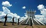 |
Federal District, 15°47′S 47°54′W |
Cultural: (i), (iv) |
— | 1987 | Planned and developed by Lúcio Costa and Oscar Niemeyer in 1956, Brasília was created ex nihilo in order to move the capital from Rio de Janeiro to a more central position. Together with Chandigarh in India it is the only place where Corbusier's design principles of urbanism have been applied on large scale. | [4] |
| Brazilian Atlantic Islands: Fernando de Noronha and Atol das Rocas Reserves | 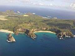 |
Pernambuco and Rio Grande do Norte, 3°51′29″S 32°25′30″W |
Natural: (vii), (ix), (x) |
42,270 (104,500); buffer zone 140,713 (347,710) | 2001 | As one of the few insular habitats in the South Atlantic, the site is essential as feeding ground and reproduction space for marine organisms including endangered and threatened species, most notably the hawksbill sea turtle. | [5] |
| Canaima National Park |  |
Bolívar, 5°20′N 61°30′W |
Natural: (vii), (viii), (ix), (x) |
3,000,000 (7,400,000) | 1994 | The park is characterized by table-top mountains (tepui) that cover 65% of the area and are of both geological and biological interest, providing habitat to a large number of endemic species. Angel Falls, the world's highest waterfall is included in the property. | [6] |
| Central Amazon Conservation Complex | 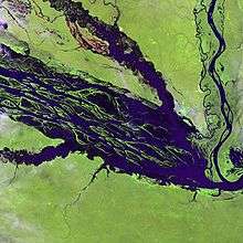 |
State of Amazonas, 2°20′0″S 62°0′30″W |
Natural: (ix), (x) |
5,323,018 (13,153,460) | 2000 [nb 1] |
As the largest protected area in the Amazon basin, the site is notable for its high biodiversity, range of habitats such as várzea and igapó forests and number of endangered species. It has been recognized by various conservation agencies as a high priority region.[nb 2] | [7] [8] |
| Central Suriname Nature Reserve | 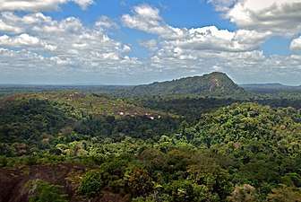 |
Sipaliwini District, 4°0′N 56°30′W |
Natural: (ix), (x) |
1,600,000 (4,000,000) | 2000 | The site comprises a large undisturbed tract of tropical forst with high biodiversity, many endemic and threatened species. Due to topography and the range of soil conditions, it has various ecoregions. | [9] |
| Cerrado Protected Areas: Chapada dos Veadeiros and Emas National Parks | 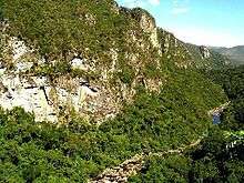 |
Central Brazil Plateau, State of Goiás, 14°0′20″S 47°41′5″W |
Natural: (ix), (x) |
367,356 (907,760) | 2001 | The two parks are characteristic of the cerrado, one of the world's oldest tropical ecosystems and an important refuge for species in times of climate change. | [10] |
| Chan Chan Archaeological Zone† | 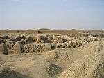 |
La Libertad, 8°6′S 79°5′W |
Cultural: (i), (iii) |
600 (1,500) | 1986 | The city of Chan Chan served as the capital of the Chimú culture. The Chimú kingdom developed along the coast of northern Peru. Chan Chan is divided into nine walled units indicating political and social division. The Chimú were conquered by the Inca in 1470. The site was listed to the List of World Heritage in Danger when it was first inscribed, as the adobe constructions are easily damaged by heavy rain and erosion. | [11] [12] [13] |
| Chavín (Archaeological Site) | 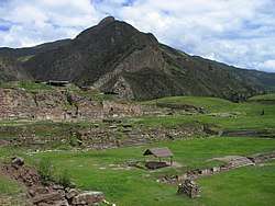 |
Huari Province, Ancash, 9°35′34″S 77°10′42″W |
Cultural: (iii) |
— | 1985 | The Chavín culture developed in the Andean highlands between 1500 and 300 BC, and the site now known as Chavín de Huantar served as the center. The site consists of a complex of terraces and squares cut from rock. It is believed the Chavín were primarily a religious-based society whose influence resulted from their culture, rather than aggressive expansion. | [14] [15] |
| Churches of Chiloé | 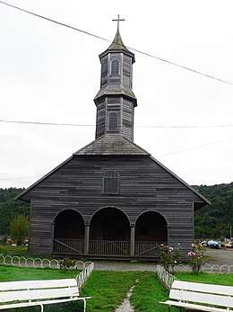 |
Chiloé Province, Los Lagos Region, 42°30′0″S 73°46′0″W |
Cultural: (ii), (iii) |
— | 2000 | The churches are the most prominent example of Chilota wooden architecture fusing European and indigenous traditions. They are a result of 17th and 18th century Jesuit missions. | [16] |
| Chiribiquete National Park– “The Maloca of the Jaguar” | 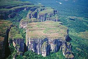 |
Caquetá and Guaviare Departments, 0°31′31″N 72°47′50″W |
Mixed: (iii), (ix), (x) |
2,782,354 (6,875,350); buffer zone 3,989,682.82 (9,858,721.0) | 2018 | Located in the north-west Colombian Amazon, Chiribiquete National Park is the largest protected area in the country. One of the defining features of the park is the presence of tepuis (the Native American word for table-top mountains), sheer-sided sandstone plateaux that dominate the forest. Over 75,000 paintings, spanning more than 20,000 years to the present, are to be seen on the walls of the 60 rock shelters around the bases of the tepuis. Believed to be linked to the worship of the jaguar, a symbol of power and fertility, these paintings depict hunting scenes, battles, dances and ceremonies. The indigenous communities, which are not directly present on the site, consider the region sacred. | [17] |
| City of Cuzco | 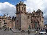 |
Cuzco, 13°31′20″S 71°59′0″W |
Cultural: (iii), (iv) |
— | 1983 | Cuzco was developed by the Inca king Pachacutec, who ruled the Kingdom of Cuzco as it expanded to become the Inca Empire in the 15th century. It became the most important city of the Inca Empire, divided into distinct areas for religious and administrative use, and surrounded by an organized system of agriculture, artisan, and industrial uses. After the Spanish conquered the empire in the 16th century, they built Baroque churches and buildings over the Inca ruins. | [18] |
| City of Potosí | 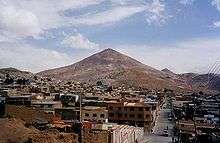 |
Potosí, Potosí Department, 19°35′1″S 65°45′11″W |
Cultural: (ii), (iv), (vi) |
130 (320) | 1987 | Following the discovery of the New World's largest silver reserves in the mid-16th century, Potosí was regarded as the world's largest industrial complex of the time. The site contains industrial facilities of the Cerro Rico, colonial public and residential architecture. | [19] |
| City of Quito | 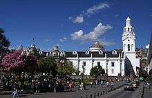 |
Quito, Quito Canton, Pichincha Province, 0°0′14″N 78°30′0″W |
Cultural: (ii), (iv) |
320 (790) | 1978 | Built in Spanish colonial style, the former capital of the Royal Audiencia of Quito.The Historic Center of Quito is the most original and best preserved historic center of its kind in Latin America. | [20] |
| Ciudad Universitaria de Caracas | 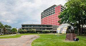 |
Municipality of Libertador, Caracas, 10°29′27″N 66°53′26″W |
Cultural: (i), (iv) |
— | 2000 | Designed by Carlos Raúl Villanueva, the university campus is considered a masterpiece of early 20th century architecture and urban planning. It derives from colonial traditions, providing an airy solution well suited to the tropical climate. | [21] |
| Coffee Cultural Landscape of Colombia | 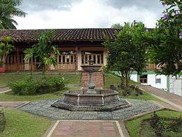 |
Caldas, Quindío and Risaralda Departments, 5°28′N 75°41′W |
Cultural: (v), (vi) |
141,120 (348,700); buffer zone 207,000 (510,000) | 2011 | The 100-year-old coffee cultivation is emblematic of Colombian culture and has impacted cultural and social traditions in music, architecture, cuisine, education and others. | [22] |
| Coro and its Port | 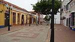 |
Falcón, 11°24′N 69°41′W |
Cultural: (iv), (v) |
107 (260); buffer zone 107 (260) | 1993 | Founded in 1527, Coro was one of the earliest colonial towns in the Americas. Its earthen constructions are the only extant example of fusion of Caribbean with Spanish Mudéjar and Dutch architecture. The site has been listed as endangered since 2005 following damage due to heavy rain and the construction of various structures in the buffer zone. | [23] [24] |
| Cueva de las Manos, Río Pinturas | 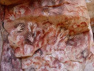 |
Santa Cruz Province, 47°9′0″S 70°40′0″W |
Cultural: (iii) |
— | 1999 | Named for the paintings of hands, the cave contains rock art from between 13,000 and 9,500 years ago that bear witness to the earliest human inhabitants in South America. | [25] |
| Discovery Coast Atlantic Forest Reserves | 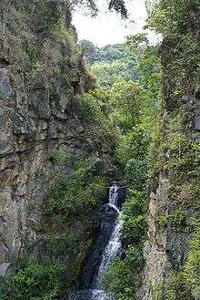 |
Atlantic Coast, Bahia and Espírito Santo states, 16°30′S 39°15′W |
Natural: (ix), (x) |
111,930 (276,600) | 1999 | The site comprises some of the last remaining Atlantic Forests and shows a very high diversity with many rare and endemic species. As such it is of high interest both for scientists and for conservation. | [26] |
| Fray Bentos Cultural-Industrial Landscape | 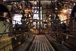 |
Río Negro Department, 33°07′04″S 58°19′54″W |
Cultural: (ii), (iv) |
274 (680); buffer zone 2,128 (5,260) | 2015 | [27] | |
| Fuerte de Samaipata |  |
Florida Province, Santa Cruz Department, 18°10′S 63°49′W |
Cultural: (ii), (iii) |
— | 1998 | Samaipata consists of remains of a town, and more prominently a large sculpted rock (14th–16th centuries) thought to have been the ceremonial centre of a pre-Hispanic culture. | [28] |
| Galápagos Islands | 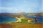 |
Galápagos Province, 0°40′S 90°30′W |
Natural: (vii), (viii), (ix), (x) |
14,066,514 (34,759,110) | 1978 | This remote archipelago of volcanic islands is famed for the high degree of endemism and is associated with Charles Darwin whose observations here contributed to the inception of Darwin's theory of evolution by natural selection. The site had been listed as endangered for various reasons[nb 3] 2007–2010. | [29] [30] [31] [32] |
| Historical Centre of the City of Arequipa | 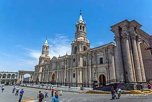 |
Arequipa, 16°24′0″S 71°32′0″W |
Cultural: (i), (iv) |
167 (410); buffer zone 165 (410) | 2000 | Arequipa is built primarily on top of sillar, a white volcanic rock, the product of nearby El Misti volcano. The architecture of the city is known for its combination of traditional indigenous styles with the new techniques of the European colonial settlers. | [33] |
| Historic Centre of Salvador de Bahia |  |
Bahia state, 12°58′0″S 38°30′0″W |
Cultural: (iv), (vi) |
— | 1985 | The colonial old town of the first Brazilian capital and town of the first slave market in the New World, has preserved a large number of brightly colored Renaissance houses decorated with stucco work from the 16th to 18th centuries. | [34] |
| Historic Centre of Santa Ana de los Ríos de Cuenca |  |
Azuay Province, 2°53′0″S 78°59′0″W |
Cultural: (ii), (iv), (v) |
200 (490) | 1999 | Founded in 1557 on an orthogonal town plan, the townscape of Cuenca is an expression of the fusion of different societies and cultures and a showcase of Renaissance urban design in Latin America. | [35] |
| Historic Centre of Lima | 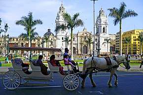 |
Lima Province, 12°3′5″S 77°2′35″W |
Cultural: (iv) |
200 (490) | 1988 [nb 4] |
Lima was founded by Francisco Pizarro in 1535 as La Ciudad de los Reyes (City of the Kings). Until the middle of the 18th century, it was the most important city in Spanish South America. The architecture and decoration combine the style of both the local population and Europe, such as in the Monastery of San Francisco, which was the site's original listing in 1988, before it was extended in 1991. | [36] [37] |
| Historic Centre of Santa Cruz de Mompox | 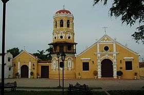 |
Bolívar Department, 9°14′0″N 74°26′0″W |
Cultural: (iv), (v) |
458 (1,130); buffer zone 632 (1,560) | 1995 | Mompox, founded in 1540 on a major river has preserved in its historic centre the colonial past with many buildings still serving their original function. | [38] |
| Historic Centre of São Luís | 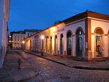 |
Maranhão state, 2°30′51″S 44°18′9″W |
Cultural: (iii), (iv), (v) |
— | 1997 | São Luís has preserved the complete rectangular town plan and a large number of historical buildings making it a prime example of a Portuguese colonial town. | [39] |
| Historic Centre of the Town of Diamantina | 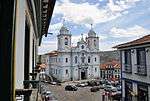 |
Minas Gerais, 18°40′0″S 43°36′0″W |
Cultural: (ii), (iv) |
29 (72) | 1999 | A well-preserved example of Baroque architecture, this 18th-century colonial town was founded in an inhospitable environment of rocky mountains and became a center of diamond mining in the 18th and 19th centuries. | [40] |
| Historic Centre of the Town of Goiás | 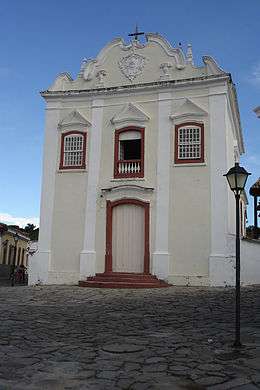 |
Goiás, 15°56′0″S 50°8′0″W |
Cultural: (ii), (iv) |
40 (99); buffer zone 44 (110) | 2001 | Founded in 1727 by the bandeirante explorer Bartolomeu Bueno da Silva, Goiás has preserved much of its colonial heritage and is an example of a European settlement in the interior of South America. | [41] |
| Historic Centre of the Town of Olinda | 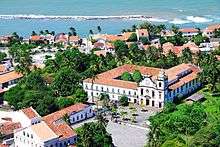 |
Pernambuco, 8°0′48″S 34°50′42″W |
Cultural: (ii), (iv) |
120 (300); buffer zone 920 (2,300) | 1982 | Founded in 1537 the town prospered as a centre of sugar-cane production. Following looting by the Dutch in the 17th century, the historic centre dates largely to the 18th century with a harmonious combination of buildings, gardens, churches, convents and chapels. | [42] |
| Historic City of Sucre | 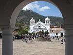 |
Oropeza Province, Chuquisaca Department, 19°2′35″S 65°15′33″W |
Cultural: (iv) |
114 (280) | 1991 | Founded by the Spanish in 1538, Sucre has retained many of its 16th century religious buildings showing the fusion of local and European architectural styles. | [43] |
| Historic Inner City of Paramaribo | 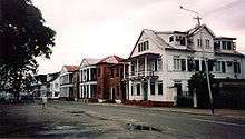 |
Paramaribo District, 5°49′34″N 55°9′0″W |
Cultural: (ii), (iv) |
30 (74); buffer zone 60 (150) | 2002 | Founded as a Dutch colonial town in the 17th century, Paramaribo has preserved its unique street plan with buildings showing the gradual influence of Dutch architectural traditions. | [44] |
| Historic Quarter of the City of Colonia del Sacramento | 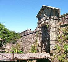 |
Colonia Department, 34°28′4″S 57°51′12″W |
Cultural: (iv) |
16 (40) | 1995 | Founded in 1680 by the Portuguese, the town changed hands between Spanish and Portuguese multiple times during the 17th and 18th centuries and was finally lost to the Spanish. Its well-preserved townscape bears testimony to the fusion of Spanish and Portuguese colonial styles. | [45] |
| Historic Quarter of the Seaport City of Valparaíso | 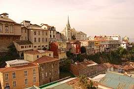 |
Valparaíso Province, 33°2′26″S 71°37′41″W |
Cultural: (iii) |
23 (57); buffer zone 45 (110) | 2003 | In the late 19th century Valparaíso prospered as a stopover point for ships travelling between the Atlantic and Pacific via the Straits of Magellan. Its historic quarter set on steep hillsides has bears testimony to this early phase of globalization. | [46] |
| Historic Sanctuary of Machu Picchu | 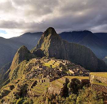 |
Cuzco, 13°7′0″S 72°35′0″W |
Mixed: (i) (iii), (vii), (ix) |
32,592 (80,540) | 1983 | At 2,340 metres (7,680 ft) above sea level, the site of Machu Picchu was constructed as an expansive mountain estate around the middle of the 15th century, and abandoned approximately 100 years later. It includes walls, terraces, and buildings constructed from rock. The city was home to about 1,200 people, mostly priests, women, and children. It was left abandoned prior to the Spanish arrival in Cuzco most likely due to smallpox. | [47] [48] |
| Historic Town of Ouro Preto | 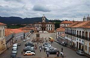 |
Minas Gerais, 20°23′20″S 43°30′20″W |
Cultural: (i), (iii) |
— | 1980 | The prosperity of the town as the center of the Brazilian gold rush in the 18th century is reflected in a large number of preserved churches, bridges and fountains many of them designed by the Baroque sculptor Aleijadinho. | [49] |
| Huascarán National Park | 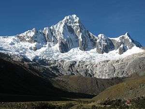 |
Ancash, 9°20′S 77°24′W |
Natural: (vii), (viii) |
340,000 (840,000) | 1985 | Huascarán National Park is located in the Cordillera Blanca mountain range of the Andes. It surrounds Huascarán, the tallest peak in Peru. The physical environment includes glaciers, ravines, and lakes, while the park is home to several regional animal species. | [50] |
| Humberstone and Santa Laura Saltpeter Works | 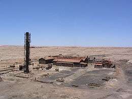 |
Tarapacá, 20°12′30″S 69°47′40″W |
Cultural: (ii), (iii), (iv) |
— | 2005 | Situated in the Atacama Desert, the two saltpeter works are representative of the saltpeter industry that flourished in northern Chile in the 19th and early 20th century and brought together people from different parts of South America and Europe creating a unique culture with its own language and customs. The site was listed as endangered from 2005 to 2019 due to damage, vandalism, looting and the general fragile nature of the structures as a result of a 40 years' lack of maintenance. | [51][52][53] |
| Iguaçu National Park | 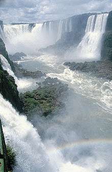 |
Paraná, 25°41′S 54°26′W |
Natural: (vii), (x) |
170,086 (420,290) | 1986 | Together with Iguazú National Park on the Argentinian side, the park protects Iguazu Falls, one of the world's largest waterfalls, and is home to many rare and endangered species such as giant anteater or the giant otter. The site had been listed as endangered 1999–2001 due to an illegally opened road through the park, dams on the Iguazu River and helicopter flights. | [54] |
| Iguazú National Park | 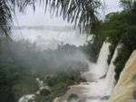 |
Misiones Province, Mesopotamia 25°31′5″S 54°8′0″W |
Natural: (vii), (x) |
55,000 (140,000) | 1984 | Together with Iguaçu National Park on the Brazilian side, the park protects Iguazu Falls, one of the world's largest waterfalls. Its subtropical rainforest is home to more than 2000 species of vascular plants and large mammals such as tapirs, giant anteaters, howler monkeys, ocelots and jaguars. | [55] |
| Ischigualasto / Talampaya Natural Parks | 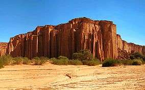 |
San Juan and La Rioja Province 30°0′S 68°0′W |
Natural: (viii) |
275,369 (680,450) | 2000 | As the most complete continental fossil site of the Triassic period (245–208 million years ago), the propertie's remains of mammals, dinosaurs and plants reveal the evolution of vertebrates. | [56] |
| Jesuit Block and Estancias of Córdoba | 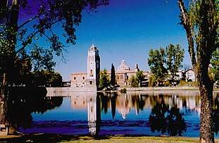 |
Córdoba 31°25′14″S 64°11′28″W |
Cultural: (ii), (iv) |
— | 2000 | Founded in the early 17th century, this Jesuit reduction has preserved the university, church, residences and five farming estates (estancias), illustrating the missionary and economic activities carried out by the Jesuits over a period of 150 years in the New World. | [57] |
| Jesuit Missions of La Santísima Trinidad de Paraná and Jesús de Tavarangue | .JPG) |
27°8′S 55°42′W |
Cultural: (iv) |
— | 1993 | The ruins of these Jesuit reductions bear testimony to the missionary, social and economical activities of the Jesuits in the Rio de la Plata Basin in the 17th and 18th centuries. | [58] |
| Jesuit Missions of Chiquitos | 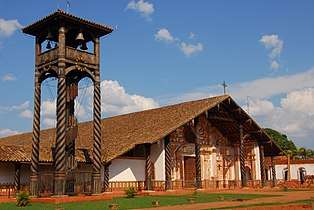 |
Santa Cruz Department, 16°0′S 60°30′W |
Cultural: (iv), (v) |
— | 1990 | Six settlements in the Chiquitania have been preserved as living heritage of their past as Jesuit reductions in the 17th and 18th centuries. Their churches largely restored in the late 20th century are a fusion of indigenous and European architectural traditions. | [59] |
| Jesuit Missions of the Guaranis: San Ignacio Miní, Santa Ana, Nuestra Señora de Loreto and Santa María Mayor (Argentina), Ruins of São Miguel das Missões (Brazil) | 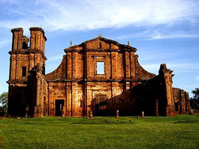 |
Misiones Province, 28°32′36″S 54°15′57″W |
Cultural: (iv) |
— | 1983 [nb 5] |
Each of the five ruined Jesuit missions founded amidst a tropical forest in the land of the Guaraní people in the 17th and 18th centuries is characterized by a specific design. | [60] [61] |
| Lines and Geoglyphs of Nazca and Pampas de Jumana | 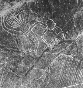 |
Nazca, 14°43′33″S 75°8′55″W |
Cultural: (i), (iii), (iv) |
— | 1994 | The large designs in the Nazca Desert are believed to have been created by the Nazca culture between 400 and 650 AD. They were created by scratching lines into the ground surface. Designs include animals such as a monkey and hummingbird, plants, and geographic shapes on a large scale. It is believed that they served a ritualistic purpose. | [62] [63] |
| Los Alerces National Park |  |
Chubut Province, 42°51′10.08″S 71°52′22.085″W |
Natural: (vii), (x) |
188,379 (465,490); buffer zone 207,313 (512,280) | 2017 | [64] | |
| Los Glaciares National Park | 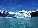 |
Santa Cruz Province, 50°0′0″S 73°14′58″W |
Natural: (vii), (viii) |
445,900 (1,102,000) | 1981 | This National Park is of exceptional beauty comprising high peaks, glacial lakes and glaciers, some of which are advancing. | [65] |
| Los Katíos National Park | .jpg) |
Antioquia and Chocó Departments, 7°40′N 77°0′W |
Natural: (ix), (x) |
72,000 (180,000) | 1994 | Situated at the Darién Gap, Los Katíos comprizes hills, forests and humid plains that are notable for their exceptional bio-diversity including many endangered animal species and endemic plants. The site was listed as endangered from 2009 to 2015 due to deforestation, illegal fishing and hunting, but has now been removed from the endangered sites list. | [66][67] |
| Malpelo Fauna and Flora Sanctuary | 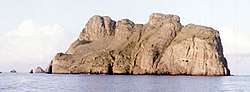 |
Cauca Department, 3°58′N 81°37′W |
Natural: (vii), (ix) |
857,500 (2,119,000) | 2006 | [68] | |
| Manú National Park | 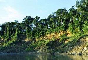 |
Madre de Dios, 12°15′S 71°45′W |
Natural: (ix), (x) |
1,716,295 (4,241,060) | 1987 [nb 6] |
The park spreads from 150 metres (490 ft) to 4,200 metres (13,800 ft) above sea-level. Manú is home to 1,000 bird species, over 200 species of mammals (100 of which are bats), and over 15,000 species of flowering plants. Prior to being recognized as a World Heritage Site, it was designated as a biosphere reserve in 1977. | [69] [70] [71] |
| National Archeological Park of Tierradentro | 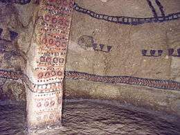 |
Inza, Cauca Department, 2°35′0″N 76°2′0″W |
Cultural: (iii) |
— | 1995 | [72] | |
| Noel Kempff Mercado National Park |  |
Santa Cruz Department, 14°16′S 60°52′W |
Natural: (ix), (x) |
1,523,446 (3,764,520) | 2000 | [73] | |
| Pampulha Modern Ensemble | Belo Horizonte, 19°51′7″S 43°58′25″W |
Cultural: (i), (ii), (iv) |
154 (380); buffer zone 1,418 (3,500) | 2016 | [74] | ||
| Pantanal Conservation Area |  |
Mato Grosso do Sul and Mato Grosso, 17°43′S 57°23′W |
Natural: (vii), (ix), (x) |
187,818 (464,110) | 2000 | [75] | |
| Paraty and Ilha Grande - Culture and Biodiversity | 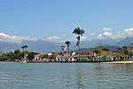 |
Rio de Janeiro 23°13′21″S 44°42′50″W |
Mixed: (v)(x) |
204,634 (505,660) | 2019 | Located between the Serra da Bocaina mountain range and the Atlantic Ocean, this cultural landscape includes the historic centre of Paraty, one of Brazil's best-preserved coastal towns, as well as four protected natural areas of the Brazilian Atlantic Forest, one of the world’s five key biodiversity hotspots. Paraty is home to an impressive diversity of species, some of which are threatened, such as the jaguar (Panthera onca), the white-lipped peccary (Tayassu pecari) and several primate species, including the woolly spider monkey (Brachyteles arachnoides), which are emblematic of the site. In the late 17thcentury, Paraty was the end-point of the Caminho do Ouro (Gold Route), along which gold was shipped to Europe. Its port also served as an entry point for tools and African slaves, sent to work in the mines. A defence system was built to protect the wealth of the port and the town. The historic centre of Paraty has retained its 18th century plan and much of its colonial architecture dating from the 18th and early 19th centuries. | [76] |
| Península Valdés | 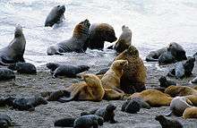 |
Viedma Department 42°30′S 64°0′W |
Natural: (x) |
360,000 (890,000) | 1999 | [77] | |
| Port, Fortresses and Group of Monuments, Cartagena | 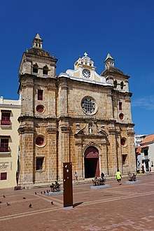 |
Bolívar Department, 10°25′0″N 75°32′0″W |
Cultural: (iv), (vi) |
— | 1984 | [78] | |
| Quebrada de Humahuaca | 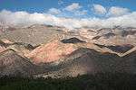 |
Jujuy Province 23°12′0″S 65°20′56″W |
Cultural: (ii), (iv), (v) |
172,116 (425,310); buffer zone 369,649 (913,420) | 2003 | [79] | |
| Qhapaq Ñan, Andean Road System | 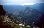 |
Cultural: (ii), (iii), (iv), (vi) |
300,000,000 (740,000,000) | 2014 | An extensive Inca communication, trade and defense network of roads covering 30,000 km (19,000 mi) and built over several centuries, this extraordinary network through one of the world’s most extreme geographical terrains linked the snow-capped peaks of the Andes—at an altitude of more than 6,000 m (20,000 ft)—to the coast, running through hot rainforests, fertile valleys and absolute deserts. | [80] | |
| Rio Abiseo National Park | — | San Martín, 7°45′S 77°15′W |
Mixed: (iii), (vii), (ix), (x) |
274,520 (678,400) | 1990 [nb 7] |
The park was created in 1983 in order to protect the region's rainforest habitat. The park is home to many endemic species such as the yellow-tailed woolly monkey, which was thought to be extinct. The site is also listed under cultural criteria, as over 30 Pre-Columbian sites have been discovered since 1985. | [81] [82] |
| Rio de Janeiro: Carioca Landscapes Between the Mountain and the Sea | 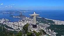 |
Rio de Janeiro, 24°50′S 43°11′W |
Cultural: (vi) |
7,249 (17,910); buffer zone 8,621 (21,300) | 2012 | The listed site consists of an exceptional urban setting rather than built heritage. It encompasses the key natural elements that have shaped and inspired the development of the city: from the highest points of the Tijuca National Park’s mountains down to the sea. They also include the Botanical Gardens, established in 1808, Corcovado Mountain with its celebrated statue of Christ and the hills around Guanabara Bay, including the extensive designed landscapes along Copacabana Bay which have contributed to the outdoor living culture of this spectacular city. Rio de Janeiro is also recognized for the artistic inspiration it has provided to musicians, landscapers and urbanists. | [83] |
| Sacred City of Caral-Supe | 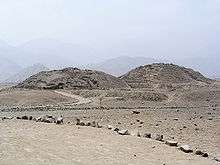 |
Lima, 10°53′30″S 77°31′17″W |
Cultural: (ii), (iii), (iv) |
626 (1,550); buffer zone 14,620 (36,100) | 2009 | The archaeological site belonged to the Norte Chico civilization that inhabited the area during the Late Archaic period. Caral is one of 18 complex urban settlements in the region and features many monuments and pyramids. Caral is the earliest known American settlement. A quipu recovered from the site demonstrates its influence on later Andean cultures. | [84] |
| San Agustín Archaeological Park | 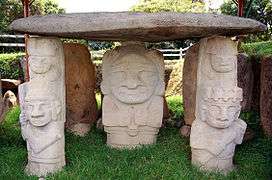 |
San Augustin and San José de Isnos, Huila Department, 1°55′0″N 76°14′0″W |
Cultural: (iii) |
— | 1995 | [85] | |
| Sanctuary of Bom Jesus do Congonhas | 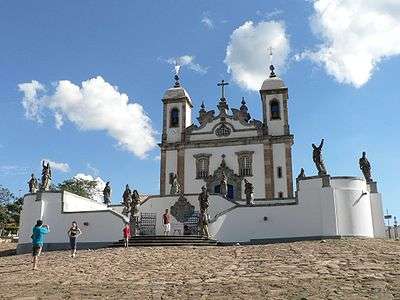 |
Congonhas, Minas Gerais, 20°29′59″S 43°51′28″W |
Cultural: (i), (iv) |
— | 1985 | [86] | |
| Sangay National Park | 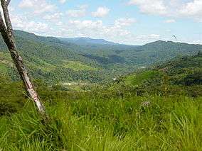 |
Morona Santiago, Chimborazo and Tungurahua Provinces, 1°50′S 78°20′W |
Natural: (vii), (viii), (ix), (x) |
271,925 (671,940) | 1983 | Endangered 1992–2005 | [87] |
| São Francisco Square in the Town of São Cristóvão |  |
São Cristóvão, Sergipe, 11°0′58″S 37°12′36″W |
Cultural: (ii), (iv) |
3.00 (7.4); buffer zone 2,500 (6,200) | 2010 | [88] | |
| Serra da Capivara National Park | 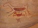 |
Piauí, 8°25′0″S 42°20′0″W |
Cultural: (iii) |
— | 1991 | [89] | |
| Sewell Mining Town | 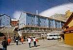 |
Machalí, Cachapoal Province, O'Higgins Region 34°5′4″S 70°22′58″W |
Cultural: (ii) |
17 (42); buffer zone 33 (82) | 2006 | [90] | |
| Tiahuanacu: Spiritual and Political Centre of the Tiahuanacu Culture | 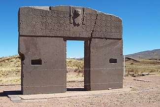 |
Ingavi Province, La Paz Department, 16°33′30″S 68°40′40″W |
Cultural: (iii), (iv) |
— | 2000 | [91] | |
| Valongo Wharf Archaeological Site | Rio de Janeiro, 22°53′49.6″S 43°11′14.62″W |
Cultural: (vi) |
0.39 (0.96); buffer zone 42 (100) | 2017 | [92] | ||
See also
Notes
- Extended in 2003 to include the Amana Sustainable Development Reserve, the Demonstration area of the Mamirauá Sustainable Development Reserve and the Anavilhanas Ecological Station; and name change from Jaú National Park, Brazil to the present name.
- It is a Centre of Plant Diversity, an Endemic Bird Area of the World and a Global 200 ecoregion.
- Reasons include insufficient prevention of possibilities for the introduction of alien species, insufficient resource allocation for conservation agencies and park management, presence of a large number of illegal immigrants, rapid uncontrolled growth of tourism, fishing over-capacity and sports fishing.
- Extended in 1991 to include "the area protected by national legislation."
- Extended in 1984 to include the four Argentinian missions making it a trans-border site; and name change from The Ruins of São Miguel das Missões to the present name.
- Minor modification of boundaries in 2009 to include all of the National Park in the World Heritage Site.
- In 1992 inscription under cultural criteria (iii) in addition to original inscription as natural site based on criteria (vii), (ix), (x).
References
- General
- "World Heritage Committee: Twenty-ninth session" (PDF). UNESCO. Retrieved 26 June 2011.
- "World Heritage Committee: Thirtieth session" (PDF). UNESCO. Retrieved 26 June 2011.
- "World Heritage Committee: Thirty-first session" (PDF). UNESCO. Retrieved 26 June 2011.
- "World Heritage Committee: Thirty-third session" (PDF). UNESCO. Retrieved 26 June 2011.
- "World Heritage Committee: Thirty-fourth session" (PDF). UNESCO. Retrieved 26 June 2011.
- Notes
- "World Heritage List". UNESCO. Retrieved 28 May 2010.
- "The Criteria for Selection". UNESCO. Retrieved 10 September 2011.
- "Atlantic Forest South-East Reserves". UNESCO. Retrieved 28 May 2010.
- "Brasília". UNESCO. Retrieved 28 May 2010.
- "Brazilian Atlantic Islands: Fernando de Noronha and Atol das Rocas Reserves". UNESCO. Retrieved 28 May 2010.
- "Canaima National Park". UNESCO. Retrieved 28 May 2010.
- "Central Amazon Conservation Complex". UNESCO. Retrieved 28 May 2010.
- "Decision - 27COM 8C.10 - Central Amazon Conservation Complex (Brazil)". UNESCO. Retrieved 26 September 2011.
- "Central Suriname Nature Reserve". UNESCO. Retrieved 28 May 2010.
- "Cerrado Protected Areas: Chapada dos Veadeiros and Emas National Parks". UNESCO. Retrieved 28 May 2010.
- "Chan Chan Archaeological Zone". UNESCO. Retrieved September 23, 2010.
- "Chan Chan Archaeological Zone – Threats to the Site". UNESCO. Retrieved September 23, 2010.
- "Historia". Complejo Arqueologico de Chan Chan (in Spanish). Patrimonio Mundial de la Humanidad. Archived from the original on September 12, 2011. Retrieved September 23, 2010.
- "Chavín (Archaeological Site)". UNESCO. Retrieved September 22, 2010.
- "Chavín de Huantar, Peru". Global Heritage Network. Archived from the original on October 23, 2010. Retrieved October 24, 2010.
- "Churches of Chiloé". UNESCO. Retrieved 28 May 2010.
- "Chiribiquete National Park – "The Maloca of the Jaguar"". UNESCO. Retrieved 1 July 2018.
- "City of Cuzco". UNESCO. Retrieved September 21, 2010.
- "City of Potosí". UNESCO. Retrieved 8 September 2011.
- "City of Quito". UNESCO. Retrieved 28 May 2010.
- "Ciudad Universitaria de Caracas". UNESCO. Retrieved 28 May 2010.
- "Coffee Cultural Landscape of Colombia". UNESCO. Retrieved 28 May 2010.
- "Coro and its Port". UNESCO. Retrieved 28 May 2010.
- 29th session 2005, pp. 102–103
- "Cueva de las Manos, Río Pinturasa". UNESCO. Retrieved 8 September 2011.
- "Discovery Coast Atlantic Forest Reserves". UNESCO. Retrieved 28 May 2010.
- "Fray Bentos Cultural-Industrial Landscape". UNESCO. Retrieved 6 July 2015.
- "Fuerte de Samaipata". UNESCO. Retrieved 8 September 2011.
- "Galápagos Islands". UNESCO. Retrieved 26 June 2011.
- 30th session 2006, pp. 70–71
- 31st session 2007, pp. 68–69
- 34th session 2010, pp. 34–35
- "Historical Centre of the City of Arequipa". UNESCO. Retrieved September 28, 2010.
- "Historic Centre of Salvador de Bahia". UNESCO. Retrieved 28 May 2010.
- "Historic Centre of Santa Ana de los Ríos de Cuenca". UNESCO. Retrieved 28 May 2010.
- "Historic Centre of Lima". UNESCO. Retrieved September 23, 2010.
- "Decision - 15COM XV.E - Extension: Historic Centre of Lima (Peru)". UNESCO. Retrieved September 23, 2010.
- "Historic Centre of Santa Cruz de Mompox". UNESCO. Retrieved 28 May 2010.
- "Historic Centre of São Luís". UNESCO. Retrieved 28 May 2010.
- "Historic Centre of the Town of Diamantina". UNESCO. Retrieved 28 May 2010.
- "Historic Centre of the Town of Goiás". UNESCO. Retrieved 10 September 2011.
- "Historic Centre of the Town of Olinda". UNESCO. Retrieved 10 September 2011.
- "Historic City of Sucre". UNESCO. Retrieved 8 September 2011.
- "Historic Inner City of Paramaribo". UNESCO. Retrieved 28 May 2010.
- "Historic Quarter of the City of Colonia del Sacramento". UNESCO. Retrieved 28 May 2010.
- "Historic Quarter of the Seaport City of Valparaíso". UNESCO. Retrieved 28 May 2010.
- "Historic Sanctuary of Machu Picchu". UNESCO. Retrieved September 21, 2010.
- "Machu Picchu". Archaeological Sites. Minnesota State University. October 14, 2004. Archived from the original on 2010-08-27. Retrieved September 21, 2010.
- "Historic Town of Ouro Preto". UNESCO. Retrieved 10 September 2011.
- "Huascarán National Park". UNESCO. Retrieved September 23, 2010.
- "Humberstone and Santa Laura Saltpeter Works". UNESCO. Retrieved 28 May 2010.
- 29th session 2005, pp. 142–143
- "The Humberstone and Santa Laura Saltpeter Works site (Chile), removed from the List of World Heritage in Danger". UNESCO. Retrieved 7 July 2019.
- "Iguaçu National Park". UNESCO. Retrieved 10 September 2011.
- "Iguazu National Park". UNESCO. Retrieved 8 September 2011.
- "Ischigualasto / Talampaya Natural Parks". UNESCO. Retrieved 8 September 2011.
- "Jesuit Block and Estancias of Córdoba". UNESCO. Retrieved 8 September 2011.
- "Jesuit Missions of La Santísima Trinidad de Paraná and Jesús de Tavarangue". UNESCO. Retrieved 28 May 2010.
- "Jesuit Missions of the Chiquitos". UNESCO. Retrieved 8 September 2011.
- "Jesuit Missions of the Guaranis: San Ignacio Mini, Santa Ana, Nuestra Señora de Loreto and Santa Maria Mayor (Argentina), Ruins of Sao Miguel das Missoes (Brazil)". UNESCO. Retrieved 8 September 2011.
- "Jesuit Missions of the Guaranis". UNESCO. Retrieved 8 September 2011.
- "Lines and Geoglyphs of Nazca and Pampas de Jumana". UNESCO. Retrieved September 27, 2010.
- Brown, David & Helaine Silverman. "New evidence for the date of the Nazca lines". Antiquity. 65 (247): 208–220. Retrieved September 27, 2010.
- "Los Alerces National Park". UNESCO. Retrieved 7 September 2017.
- "Los Glaciares National Park". UNESCO. Retrieved 8 September 2011.
- "Los Katíos National Park". UNESCO. Retrieved 28 May 2010.
- 33rd session 2009, p. 83
- "Malpelo Fauna and Flora Sanctuary". UNESCO. Retrieved 28 May 2010.
- "Manú National Park". UNESCO. Retrieved September 23, 2010.
- "Decision - 33COM 8B.39 - Natural properties - Examination of minor boundary modifications - Manú National Park (Peru)". UNESCO. Retrieved September 23, 2010.
- "Conservation". The Living Edens – Manu. Public Broadcasting Service. Retrieved September 23, 2010.
- "National Archeological Park of Tierradentro". UNESCO. Retrieved 28 May 2010.
- "Noel Kempff Mercado National Park". UNESCO. Retrieved 8 September 2011.
- "Pampulha Modern Ensemble". UNESCO. Retrieved 28 September 2017.
- "Pantanal Conservation Area". UNESCO. Retrieved 10 September 2011.
- "Paraty and Ilha Grande - Culture and Biodiversity". UNESCO. Retrieved 6 July 2019.
- "Península Valdés". UNESCO. Retrieved 8 September 2011.
- "Port, Fortresses and Group of Monuments, Cartagena". UNESCO. Retrieved 28 May 2010.
- "Quebrada de Humahuaca". UNESCO. Retrieved 8 September 2011.
- "Qhapaq Ñan, Andean Road System". UNESCO. Retrieved 2 August 2014.
- "Rio Abiseo National Park". UNESCO. Retrieved September 24, 2010.
- "Decision - 16COM X.A - Inscription: Rio Abiseo National Park (Peru)". UNESCO. Retrieved September 24, 2010.
- "Rio de Janeiro: Carioca Landscapes between the Mountain and the Sea". UNESCO. Retrieved July 2, 2011.
- "Sacred City of Caral-Supe". UNESCO. Retrieved September 28, 2010.
- "San Agustín Archaeological Park". UNESCO. Retrieved 28 May 2010.
- "Sanctuary of Bom Jesus do Congonhas". UNESCO. Retrieved 10 September 2011.
- "Sangay National Park". UNESCO. Retrieved 28 May 2010.
- "São Francisco Square in the Town of São Cristóvão". UNESCO. Retrieved 10 September 2011.
- "Serra da Capivara National Park". UNESCO. Retrieved 10 September 2011.
- "Sewell Mining Town". UNESCO. Retrieved 28 May 2010.
- "Tiwanaku: Spiritual and Political Centre of the Tiwanaku Culture". UNESCO. Retrieved 8 September 2011.
- "Valongo Wharf Archaeological Site". UNESCO. Retrieved 28 September 2017.
External links
- UNESCO World Heritage Centre official website
- UNESCO World Heritage List official website
- VRheritage.org – documentation of World Heritage Sites
- Worldheritage-Forum – Information and Weblog on World Heritage Issues
Lists of World Heritage Sites in the Americas | ||
|---|---|---|
| North America | ||
| Central America | ||
| The Caribbean |
| |
| South America | ||
| Locations | ||
|---|---|---|
| Related | ||
This article is issued from Wikipedia. The text is licensed under Creative Commons - Attribution - Sharealike. Additional terms may apply for the media files.