L'Abergement-de-Varey
L'Abergement-de-Varey is a commune in the department of Ain in eastern France.
L'Abergement-de-Varey | |
|---|---|
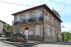 The town hall in L'Abergement-de-Varey | |
 Coat of arms | |
Location of L'Abergement-de-Varey 
| |
 L'Abergement-de-Varey  L'Abergement-de-Varey | |
| Coordinates: 46°00′28″N 5°25′31″E | |
| Country | France |
| Region | Auvergne-Rhône-Alpes |
| Department | Ain |
| Arrondissement | Belley |
| Canton | Ambérieu-en-Bugey |
| Intercommunality | Plaine de l'Ain |
| Government | |
| • Mayor (2014-2020) | Max Orset |
| Area 1 | 9.15 km2 (3.53 sq mi) |
| Population (2017-01-01)[1] | 248 |
| • Density | 27/km2 (70/sq mi) |
| Demonym(s) | Abergementais, Abergementaises |
| Time zone | UTC+01:00 (CET) |
| • Summer (DST) | UTC+02:00 (CEST) |
| INSEE/Postal code | 01002 /01640 |
| Elevation | 290–748 m (951–2,454 ft) (avg. 380 m or 1,250 ft) |
| 1 French Land Register data, which excludes lakes, ponds, glaciers > 1 km2 (0.386 sq mi or 247 acres) and river estuaries. | |
Geography
The commune is located in the first foothills of the Bugey, not far from Pont-d'Ain. Highway 59 crosses the commune, which is situated on a hillside.
Name
There are four communes in Ain, with the name abergement, which is typical of the Jura, and also exists in Saône-et-Loire, Côte-d'Or, and Doubs; the other three are Le Petit-Abergement, Le Grand-Abergement, L'Abergement-Clémenciat. It apparently designated agricultural concessions granted from the 11th to the 15th century.
Population
| Historical population | ||
|---|---|---|
| Year | Pop. | ±% |
| 2006 | 198 | — |
| 2007 | 195 | −1.5% |
| 2008 | 194 | −0.5% |
| 2009 | 207 | +6.7% |
| 2010 | 221 | +6.8% |
| 2011 | 234 | +5.9% |
| 2012 | 235 | +0.4% |
| 2013 | 236 | +0.4% |
| 2014 | 239 | +1.3% |
| 2015 | 241 | +0.8% |
| 2016 | 243 | +0.8% |
Sights
- Neo-roman church built in the 19th century
- Monument to the Resistance
See also
External links
| Wikimedia Commons has media related to L'Abergement-de-Varey. |
| Authority control |
|
|---|
This article is issued from Wikipedia. The text is licensed under Creative Commons - Attribution - Sharealike. Additional terms may apply for the media files.