Korkut
Korkut (Kurdish: Têlî),[3] is a district and eponymous city center of Muş Province of Turkey. The mayor is Haşim Arık (AKP).
Korkut Têlî | |
|---|---|
 Korkut | |
| Coordinates: 38°44′19″N 41°46′58″E | |
| Country | Turkey |
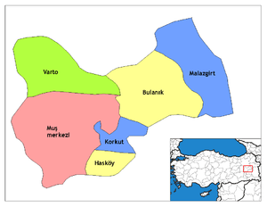
| Province | Muş |
| Government | |
| • Mayor | Haşim Arık (AKP) |
| • Kaymakam | Oğuz Şenlik |
| Area | |
| • District | 503.34 km2 (194.34 sq mi) |
| Elevation | 1,300 m (4,300 ft) |
| Population (2012)[2] | |
| • Urban | 3,524 |
| • District | 26,992 |
| • District density | 54/km2 (140/sq mi) |
| Post code | 497xx |
| Website | www.korkut.bel.tr |
History
Human settlement of the area is at least 10,000 years. Korkut has a tell from which the town derived its old name. This tell is estimated to be dated to the Old Bronze Age (around 3000 BC) but has not been examined archaeologically. In the 9th century BC, the area was part of the Urartu state.
The Armenian Taron kingdom ruled the town from the 4th century until the beginning of the 9th century, and the Christian diocese of Taron still hold nominal sway in the area as a titular see. In the 9th century the town came under the control of a rival Armenian kingdom the Bagratians. This lasted until In 967, the Byzantine Empire took control of western Anatolyia.
Seyit İbrahim Türk took the town in the 11th century, and it was about this time that the earliest references to the name Til are recorded.
Legend holds that The Byzantine emperor Basileios who was elected Byzantine emperor in 867, was originally a Til peasant.
Records of the Armenian church records that in 1890 there were 40 Armenian households in the village and 20 Kurdish.[4] Although the church records show that by 1910 there were only 20 Armenian households and 1000 Kurdish the true figure is probably about 50 Armenian households.[5] The Armenian church records that at the Armenian Genocide there were 52 Armenian households.
Before World War 1 the town had a church building dedicated to saint Asdvadzadzin.[6]
The name of the town was changed to Korkut in 1964.
References
- "Area of regions (including lakes), km²". Regional Statistics Database. Turkish Statistical Institute. 2002. Retrieved 2013-03-05.
- "Population of province/district centers and towns/villages by districts - 2012". Address Based Population Registration System (ABPRS) Database. Turkish Statistical Institute. Retrieved 2013-02-27.
- Adem Avcıkıran (2009). Kürtçe Anamnez Anamneza bi Kurmancî (PDF) (in Turkish and Kurdish). p. 56. Retrieved 17 December 2019.
- https://www.houshamadyan.org/mapottomanempire/vilayet-of-bitlispaghesh/kaza-of-moush/locale/demography.html Moush Demography].
- Moush Demography.
- Moush Demography.