Interstate 74 in Illinois
Interstate 74 (I-74) in the U.S. state of Illinois is a major northwest–southeast Interstate Highway that runs across the central portion of the state. It runs from the Iowa state line at the Mississippi River near the city of Rock Island and runs southeast to the Indiana state line east of Danville, a distance of 220.34 miles (354.60 km).[2] The highway runs through the major cities of Champaign, Bloomington, Peoria, and Moline.
| ||||
|---|---|---|---|---|
| Everett McKinley Dirksen Memorial Highway[1] | ||||
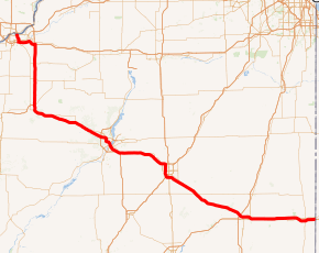
I-74 highlighted in red | ||||
| Route information | ||||
| Maintained by IDOT | ||||
| Length | 220.34 mi[2] (354.60 km) | |||
| Major junctions | ||||
| West end | ||||
| East end | ||||
| Location | ||||
| Counties | Rock Island, Henry, Knox, Peoria, Tazewell, Woodford, McLean, DeWitt, Piatt, Champaign, Vermilion | |||
| Highway system | ||||
| ||||

The highway is officially named after Everett McKinley Dirksen, a Republican Senator and U.S. Congressman from Pekin from 1933 to his death in 1969.[1]
History
In November 2006 major work was completed on the Upgrade 74 project for the portion of I-74 in the Midwest. This multi-year project, begun in April 2002, saw the complete renovation of I-74 through East Peoria and Peoria. Most notably the interstate was widened to three lanes through the cities, many blind or hairpin exits and entrances to the highway were removed or corrected, and many bridges crossing the highway were replaced. The biggest part of this project was work on the Murray Baker Bridge, over which I-74 crosses the Illinois River. The bridge was completely closed to traffic while being partially dismantled and reconstructed from April 2 to October 15, 2005. During this time I-74 was disconnected between Peoria and East Peoria.[3] In late March 2013, the biggest road reconstruction project in the Peoria area since the 2002-2006 project- a complete $86.6 million revision of the Morton, Illinois I-74/I-155 interchange system- started its beginning phases (Morton, a hub for the two interstates and the site of facilities for Caterpillar, Pepsi, and Libby's Pumpkin, is a growing Peoria suburb, across the Illinois River, east of East Peoria and Pekin, in Tazewell County). This latest project was scheduled to be finished by mid-2016 and the reconstruction is being scheduled in phases to minimize traffic disruption.[4]
Future
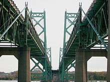
The Iowa and Illinois departments of transportation are in the planning stages to build a new bridge to replace the aging I-74 Bridge. The Iowa-bound bridge opened in 1935; the Illinois bridge in 1958.[5] In addition to replacing the bridges, the scope of the bi-state coalition's plan includes updating 7 miles (11 km) of I-74 mainline and interchanges from 53rd Street in Davenport to the Avenue of the Cities in Moline.[6]
Exit list
| County | Location | mi | km | Exit | Destinations | Notes |
|---|---|---|---|---|---|---|
| Mississippi River | 0.00 | 0.00 | Continuation into Iowa | |||
| I-74 Bridge | ||||||
| Rock Island | Moline | 0.64 | 1.03 | 1 | River Drive | Eastbound exit and westbound entrance only |
| 0.94– 1.17 | 1.51– 1.88 | 2 | ||||
| 2.09 | 3.36 | 3 | Avenue of the Cities | |||
| 3.59 | 5.78 | 4 | Signed as exits 4A (west) and 4B (east) | |||
| 4.51 | 7.26 | 5 | Eastern end of US 6 concurrency; western end of I-280 concurrency; eastbound exits signed 5A (I-280 west) and 5B (US 6 east) | |||
| Henry | Colona Township | 13.89 | 22.35 | — | Eastern end of I-280 concurrency; western end of IL 110/CKC concurrency | |
| Lynn Township | 23.92 | 38.50 | 24 | |||
| Woodhull | 31.89 | 51.32 | 32 | |||
| Knox | Galesburg | 45.50 | 73.23 | 46A | Eastern end of IL 110/CKC concurrency | |
| 46B | ||||||
| 48.09 | 77.39 | 48 | East Main Street – Galesburg | Westbound signed as exits 48A (west) and 48B (east) | ||
| Knoxville | 50.87 | 81.87 | 51 | Knoxville | ||
| Knox Township | 53.54 | 86.16 | 54 | |||
| Peoria | Brimfield Township | 71.15 | 114.50 | 71 | ||
| Brimfield | 74.55 | 119.98 | 75 | Brimfield, Oak Hill | ||
| Kickapoo Township | 81.78 | 131.61 | 82 | Kickapoo, Edwards | ||
| 86.78 | 139.66 | 87A | Western terminus of I-474; I-474 exit 0 | |||
| 87B | Southern terminus of IL 6; IL 6 exit 0 | |||||
| Peoria | 88.69 | 142.73 | 88 | Access to US 150 signed eastbound only | ||
| 89.15 | 143.47 | 89 | Access from eastbound I-74 to westbound US 150 and from eastbound US 150 to westbound I-74 at exit 88 | |||
| 90.22 | 145.20 | 90 | Gale Avenue | |||
| 91.41 | 147.11 | 91 | University Street | |||
| 92.41 | 148.72 | 92A | ||||
| 92B | ||||||
| Glendale Avenue | Former right-in/right-out; replaced by exit 92B | |||||
| Jefferson Avenue | Former interchange with no eastbound exit; replaced by exit 93 | |||||
| 93.17– 93.26 | 149.94– 150.09 | 93 | Eastbound exit and westbound entrance; serves General Wayne A. Downing Peoria International Airport | |||
| Western end of IL 29 concurrency; westbound exit and eastbound entrance; serves General Wayne A. Downing Peoria International Airport | ||||||
| Illinois River | 93.36– 93.89 | 150.25– 151.10 | Murray Baker Bridge | |||
| Tazewell | East Peoria | 93.21 | 150.01 | 94 | Southern terminus of IL 40 | |
| 95.02 | 152.92 | 95A | Eastern end of IL 29 concurrency; signed as exit 95 westbound | |||
| 95.33 | 153.42 | 95B | Eastbound exit and westbound entrance | |||
| 95.52 | 153.72 | 96 | ||||
| 97.66 | 157.17 | 98 | Pinecrest Drive | |||
| 99.00 | 159.33 | 99 | Eastern terminus of I-474; I-474 exit 15 | |||
| Morton | 101.02 | 162.58 | 101 | Northern terminus of I-155 | ||
| 102.06 | 164.25 | 102 | Morton | |||
| Woodford | Goodfield | 112.01 | 180.26 | 112 | ||
| McLean | Carlock | 119.83 | 192.85 | 120 | Carlock | |
| Dry Grove Township | 124.99 | 201.15 | 125 | |||
| Normal Township | 127.10 | 204.55 | 127 | Western end of I-55/US 51 concurrency; I-55 south exit 163 | ||
| Bloomington | 130.46 | 209.96 | 160 | Exit number follows I-55 | ||
| 133.34 | 214.59 | 134A | Eastern end of I-55 concurrency; I-55 north exit 157A | |||
| 133.62 | 215.04 | 134B | ||||
| Bloomington Township | 135.20 | 217.58 | 135 | Eastern end of US 51 concurrency | ||
| Downs | 142.21 | 228.86 | 142 | Downs | ||
| Le Roy | 149.00 | 239.79 | 149 | Le Roy | ||
| Empire Township | 151.79 | 244.28 | 152 | |||
| DeWitt | Farmer City | 158.74 | 255.47 | 159 | ||
| Piatt | Blue Ridge Township | 165.86 | 266.93 | 166 | Mansfield | |
| Champaign | Mahomet | 171.51 | 276.02 | 172 | ||
| 173.40 | 279.06 | 174 | Prairieview Road | |||
| Champaign | 178.65 | 287.51 | 179 | Signed as exits 179A (south) & 179B (north); exit 237 on I-57 | ||
| 180.27 | 290.12 | 181 | Prospect Avenue | |||
| 181.02 | 291.32 | 182 | Neil Street | |||
| Urbana | 182.30 | 293.38 | 183 | Lincoln Avenue | ||
| 183.58 | 295.44 | 184 | ||||
| 185.05 | 297.81 | 185 | ||||
| St. Joseph | 191.90 | 308.83 | 192 | St. Joseph | ||
| Ogden | 196.41 | 316.09 | 197 | |||
| Vermilion | Oakwood Township | 199.42 | 320.94 | 200 | ||
| 205.97 | 331.48 | 206 | Potomac, Oakwood | |||
| Danville Township | 209.57 | 337.27 | 210 | |||
| Danville | 213.23 | 343.16 | 214 | G Street | ||
| 213.95 | 344.32 | 215A | Cloverleaf interchange | |||
| 215B | ||||||
| 215.48 | 346.78 | 216 | Bowman Avenue, Perrysville Road | |||
| Illinois–Indiana line | 219.33– 219.66 | 352.98– 353.51 | 220 | Lynch Road | Eastbound entrance extends into Indiana | |
| Continuation into Indiana | ||||||
1.000 mi = 1.609 km; 1.000 km = 0.621 mi
| ||||||
References
- State of Illinois (n.d.). "605 ILCS 15 / Dirksen Memorial Highway Act". Illinois Compiled Statutes. Retrieved November 8, 2007.
- Staff (October 31, 2002). "Main Routes of the Dwight D. Eisenhower National System of Interstate and Defense Highways as of October 31, 2002". Federal Highway Administration. Retrieved September 29, 2006.
- Staff (January 4, 2007). "Upgrade 74". Illinois Department of Transportation. Retrieved November 26, 2006.
- Buedel, Matt. "$86.6 million road project begins Monday near Morton". Journal Star. Peoria, IL. Retrieved March 28, 2013.
- Dispatch/Argus staff (2005). "Mississippi Bridge Timeline". The Dispatch / The Rock Island Argus. Progress 2005. Retrieved July 25, 2011.
- Staff. "I-74 Corridor Overview". Iowa Department of Transportation. Retrieved July 25, 2011.
External links
| Wikimedia Commons has media related to Interstate 74 in Illinois. |
| Previous state: Iowa |
Illinois | Next state: Indiana |