Illinois Route 116
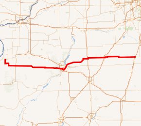
Illinois Route 116 (IL 116) is a 176.07-mile-long (283.36 km) cross-state rural state highway that runs from U.S. Route 34 (US 34) by Gladstone east to the intersection of US 45 (North Front Street) and Old US 45, on the north side of Ashkum.[1]
| |||||||
|---|---|---|---|---|---|---|---|
IL 116 highlighted in red | |||||||
| Route information | |||||||
| Maintained by IDOT | |||||||
| Length | 176.07 mi[1] (283.36 km) | ||||||
| Existed | 1924[2]–present | ||||||
| Major junctions | |||||||
| West end | |||||||
| East end | |||||||
| Location | |||||||
| Counties | Henderson, Warren, Knox, Fulton, Peoria, Tazewell, Woodford, Livingston, Ford, Iroquois | ||||||
| Highway system | |||||||
| |||||||

Route description
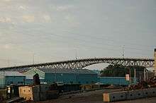
The western terminus of Illinois 116 is approximately 10 miles (16 km) from the Iowa state line, east of Burlington, Iowa. It crosses the Illinois River from Peoria to East Peoria with Illinois Route 8 on the Cedar Street Bridge.
On the southeast side of the Illinois River, Route 116, U.S. Route 24 and U.S. Route 150 form a wrong-way concurrency. Travelling northeast along the river, U.S. 150 is marked west before crossing the river to enter Peoria, Illinois 116 is marked east, and U.S. 24 is also marked east before branching to north of Washington. Travelling southwest, U.S. 150 is marked east before branching to Morton, Illinois 116 is marked west before crossing the river to enter Peoria on its southern side, and U.S. 24 is also marked west before continuing south with Illinois Route 29.
History
| |
|---|---|
| Location | Peoria–Biggsville, Illinois |
| Length | 80 mi (130 km) |
| Existed | 1926–1938 |
U.S. Route 124 (US 124) was a U.S. Highway that was commissioned from 1926 to 1938, and was located in Illinois, traveling from Peoria through Biggsville. It was approximately 80 miles (130 km) in length, and followed much of the route of IL 116, prior to its decommissioning. SBI Route 116 originally traveled separately from east of Ashkum to East Peoria.
US 124 was one of the original 1928 US routes in Illinois, since US routes didn't appear on Illinois maps until then. It originally went from Peoria to Galesburg, along with the then IL 8, via Farmington and Maquon on the route of the current IL 116, west from Peoria to IL 97, north to IL 8, west to IL 97, then northwest on IL 97 to Galesburg, with the last few miles on the current US 150.[3]
In 1934, US 124 was rerouted west on the current IL 116 to near Biggsville, where it connected to US 34, for access to the Mississippi River crossing into Iowa. Westbound traffic from Peoria had a choice. Proceed along US 24 to cross the Mississippi River at Quincy (south-west route) – the old Peoria to Quincy stage coach route, or take US 124 to cross the Mississippi River (US 34) at Burlington, Iowa (north-west route).
With the completion of Interstate 474 as a western bypass of Peoria in 1978, an Interstate connector (exit 3 on Interstate 474) was constructed as the eastern terminus for the proposed western Illinois expressway (Peoria to Kansas City via Macomb and Quincy). The connector provides access to IL 116.
Related routes
| |
|---|---|
| Location | Henderson County |
Illinois Route 97A was a short rural spur (state maintained) that ran from IL 97 (later U.S. Route 124; now IL 116) south of Media, south to the community of Raritan.
- 1937 IL-97A was a spur off the current IL-116, Media to Raritan. This 1924 route designation was dropped.
- 1938 - US Route 124 was decommissioned and changed to Illinois 116 as an extension of that route in east central Illinois. Illinois 116 was a popular agricultural and commercial truck route from Burlington, Iowa (on the Mississippi River) to Peoria, Illinois (on the Illinois River) during World War II and through the late 1960s. This was due to the: Iowa Army Ammunition Plant near Burlington; active strip mining of coal in Fulton County (largely south of the route); farm livestock traffic to the Peoria stockyards; and grain transport (corn and soybeans) to the Illinois and Mississippi barge terminals.
Major intersections
| County | Location | mi | km | Destinations | Notes |
|---|---|---|---|---|---|
| Henderson | | 0.0 | 0.0 | Interchange under construction as part of the Biggsville bypass; west end of IL 94 overlap | |
| | 5.1 | 8.2 | East end of IL 94 overlap | ||
| Warren | | 19.3 | 31.1 | ||
| Roseville | 20.4 | 32.8 | |||
| Knox | St. Augustine | 34.0 | 54.7 | ||
| Fulton | | 47.5 | 76.4 | ||
| Farmington | 56.0 | 90.1 | West end of IL 78 overlap | ||
| Fulton–Peoria county line | | 57.0 | 91.7 | East end of IL 78 overlap | |
| Peoria | Bellevue | 72.5 | 116.7 | ||
| Peoria | 76.4 | 123.0 | West end of IL 8 overlap | ||
| Illinois River | 77.7 | 125.0 | Cedar Street Bridge | ||
| Tazewell | East Peoria | 78.5 | 126.3 | Edmund Street | Interchange |
| 79.0 | 127.1 | Interchange; west end of US 24 / IL 29 overlap | |||
| 79.7 | 128.3 | West end of US 150 overlap; east end of IL 8 overlap | |||
| 79.9 | 128.6 | Interchange; east end of IL 29 overlap | |||
| 83.9 | 135.0 | Interchange; east end of US 24 / US 150 overlap | |||
| | 85.0 | 136.8 | |||
| Woodford | Metamora | 94.8 | 152.6 | ||
| | 99.4 | 160.0 | West end of IL 117 overlap | ||
| Benson | 108.7 | 174.9 | East end of IL 117 overlap | ||
| | 114.2 | 183.8 | |||
| | 114.6 | 184.4 | West end of IL 251 overlap | ||
| | 115.6 | 186.0 | East end of IL 251 overlap | ||
| Livingston | Pontiac | 134.3 | 216.1 | ||
| 135.7 | 218.4 | West end of Historic US 66 overlap | |||
| 136.3 | 219.4 | East end of Historic US 66 overlap | |||
| Saunemin | 148.7 | 239.3 | |||
| Ford | | 160.5 | 258.3 | ||
| Iroquois | Ashkum | 175.3 | 282.1 | ||
| 176.07 | 283.36 | ||||
1.000 mi = 1.609 km; 1.000 km = 0.621 mi
| |||||
See also
References
- Illinois Technology Transfer Center (2006). "T2 GIS Data". Archived from the original on August 10, 2007. Retrieved November 8, 2007.
- Carlson, Rich (February 7, 2007). "Illinois Highways Page: Routes 101 thru 120". Retrieved March 19, 2007.
- Carlson, Rich (February 7, 2007). "Illinois Highways Page: Routes 121 thru 140". Retrieved March 19, 2007.