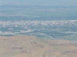
Iğdır
Iğdır (Turkish [ˈɯːdɯɾ] (![]()
Iğdır | |
|---|---|
City & Municipality | |
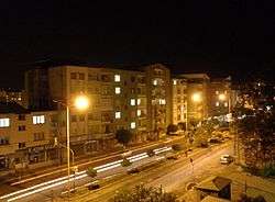 Iğdır at night | |
 Iğdır Iğdır | |
| Coordinates: 39°55′15″N 44°02′40″E | |
| Country | Turkey |
| Province | Iğdır |
| Government | |
| • Elected Mayor | Yaşar Akkuş (HDP) |
| • State appointed trustee | Enver Ünlü |
| Area | |
| • District | 1,431.17 km2 (552.58 sq mi) |
| Elevation | 850 m (2,790 ft) |
| Population (2012)[2] | |
| • Urban | 82,656 |
| • District | 128,976 |
| • District density | 90/km2 (230/sq mi) |
| Post code | 76000 |
| Website | www.igdir.bel.tr |
Etymology
The city and province are named after a western Turkish clan called Iğdır that belonged to a branch of the Oghuz Turks.[4][5] They spread throughout Anatolia and there are several towns and villages named Iğdır in Eskişehir Province and other parts of Turkey today.[4] The city in Armenian is called Իգդիր, Igdir, also Ցոլակերտ, Tsolakert, after an ancient settlement nearby. The city is most commonly called Îdir in Kurdish, however the city is also called Reşqelas in Kurdish, which is of Kurdish etymology.
History
Iğdır went by the Armenian name of Tsolakert during the Middle Ages.[6] When the Spanish traveler Ruy González de Clavijo passed through this region in the early 15th century, he stayed a night in a castle he called Egida, located at the foot of Mount Ararat. Clavijo describes it as being built upon a rock and ruled by a woman, the widow of a brigand Timurlane had put to death.[7] Because modern Iğdır has no such rock, and is a considerable distance from the Ararat foothills, it is believed that medieval Iğdır was located at a different site, at a place also known as Tsolakert, now called Taşburun. Russian excavations there at the end of the 19th century discovered the ruins of houses and what was identified as a church, as well as traces of fortifications. The settlement may have been abandoned after an earthquake in 1664.[8] In 1555 the town became a part of the Safavid Empire, remaining under Persian rule (with brief military occupations by the Ottomans in 1514, between 1534–35, 1548–49, 1554–55, 1578–1605, 1635–36 and 1722–46) until it fell into the hands of the Russian Empire after the Russo-Persian War of 1826-1828.[6]
Modern history
Iğdır was taken by the Russian Empire from Persia after the latter's defeat in the Russo-Persian War of 1826-1828. It was organized as part of the Armenian Oblast in 1828 and made a part of the Georgia-Imeretia Governorate in 1840, and then the Surmalu Uyezd of the Erivan Governorate in 1850. According to the Russian family lists accounts from 1886, of the total 71,066 inhabitants of the districts 34,351 were Azerbaijanis (48.3%, mentioned as 'Tatars' in the source), 22,096 Armenians (31.1%) and 14,619 Kurds (20.6%).[9] Population of Iğdır was monoethnic and consisted of 2912 Armenians according to 1894 publication.[10] Under Russian rule, two primary schools, one for boys and the other for girls, and three churches were opened and 100 Armenian families were allowed to move to Iğdır. The town's population rose to 10,000 in 1914 and largely busied itself with agriculture and commerce.[6]
Following the Russian Revolution of October 1917, the area came under the control of a temporary administrative committee created by the three main ethnic groups in the Caucasus. Though it attempted to negotiate a truce with the Ottoman Empire, Ottoman forces launched an eastward offensive and took Iğdır on May 20, 1918. They occupied it until the signing of the Armistice of Mudros in November 1918. The Republic of Armenia then assumed control over Iğdır. The Armenian population suffered heavily during the grueling winter of 1918–19, as famine, disease and the cold killed many.[11][12] In May 1919, its status was elevated to that of a city.[13]
Based on the boundaries drawn by US State Department in November 1920, Iğdır was envisaged as an integral part of the Armenian republic. However, in September 1920 the Government of the Grand National Assembly of Turkey led by Mustafa Kemal launched a war to eliminate the republic and overran Iğdır.[14] Turkish General Kâzım Karabekir commanded the armies but his forces were initially unable to take Iğdır due to strong Armenian resistance.[15] However, within a few days, on October 20, 1920, the Turkish army managed to drive the Armenian forces out of Iğdır.[16] According to official Turkish documents, after their defeat in the Shahtahti area, Armenian forces abandoned Iğdır. They burned the Markara Bridge which spanned the Araxes river and retreated to the northern bank on November 13, 1920. Turkey annexed the region of Iğdır after the conclusion of several peace treaties, and its territorial gains were mainly formalized under the 1921 Treaty of Kars.
In the early years of the Republic of Turkey, Iğdır was a district of the province of Bayazıt. It was made a part of the Kars Province in 1934 and remained part of it until it became the seat of the newly formed Iğdır Province on 27 May 1992.[17]
Government
In the municipal elections of March 2019, Yaşar Akkuş from the Peoples' Democratic Party (HDP) was elected mayor.[18] He was dismissed due to terror related investigations on 15 May 2020,[19] and Enver Ünlü, the Governor of the province,[20] was appointed as a trustee for the municipality on the same day.[19]
Geography
The city of Iğdır sits on a plain at a lower altitude than most of Turkey's eastern provinces. This allows agricultural production including apples, tomatoes, cucumbers, peaches, pears, sugar beet, watermelons and melons. However, the most famous produce of Iğdır are cotton and apricots.
Climate
Iğdır has a continental semi-arid climate (Köppen climate classification: BSk) with hot and dry summers and cold and snowy winters. Iğdır is one of the driest cities in Turkey, averaging 261 mm (10.3 in) of precipitation per year.
| Climate data for Iğdır (1960-2012) | |||||||||||||
|---|---|---|---|---|---|---|---|---|---|---|---|---|---|
| Month | Jan | Feb | Mar | Apr | May | Jun | Jul | Aug | Sep | Oct | Nov | Dec | Year |
| Record high °C (°F) | 18.3 (64.9) |
18.4 (65.1) |
27.0 (80.6) |
33.4 (92.1) |
35.0 (95.0) |
38.0 (100.4) |
41.5 (106.7) |
42.0 (107.6) |
37.8 (100.0) |
33.0 (91.4) |
25.2 (77.4) |
22.2 (72.0) |
42.0 (107.6) |
| Average high °C (°F) | 2.1 (35.8) |
5.2 (41.4) |
12.7 (54.9) |
19.6 (67.3) |
24.4 (75.9) |
29.3 (84.7) |
33.3 (91.9) |
33.0 (91.4) |
28.8 (83.8) |
21.3 (70.3) |
12.9 (55.2) |
5.2 (41.4) |
19.0 (66.2) |
| Daily mean °C (°F) | −3.3 (26.1) |
−0.5 (31.1) |
6.4 (43.5) |
13.1 (55.6) |
17.7 (63.9) |
22.1 (71.8) |
25.8 (78.4) |
25.1 (77.2) |
19.9 (67.8) |
12.7 (54.9) |
5.7 (42.3) |
−0.1 (31.8) |
12.0 (53.7) |
| Average low °C (°F) | −7.9 (17.8) |
−5.5 (22.1) |
0.3 (32.5) |
6.4 (43.5) |
10.6 (51.1) |
14.4 (57.9) |
18.1 (64.6) |
17.4 (63.3) |
12.3 (54.1) |
6.2 (43.2) |
0.3 (32.5) |
−4.3 (24.3) |
5.7 (42.2) |
| Record low °C (°F) | −27.2 (−17.0) |
−28.0 (−18.4) |
−22.2 (−8.0) |
−7.6 (18.3) |
0.1 (32.2) |
2.4 (36.3) |
8.0 (46.4) |
8.6 (47.5) |
1.6 (34.9) |
−7.0 (19.4) |
−13.5 (7.7) |
−30.2 (−22.4) |
−30.2 (−22.4) |
| Average precipitation mm (inches) | 13.6 (0.54) |
17.2 (0.68) |
20.7 (0.81) |
37.3 (1.47) |
47.9 (1.89) |
33.2 (1.31) |
14.9 (0.59) |
10.5 (0.41) |
11.1 (0.44) |
24.6 (0.97) |
16.8 (0.66) |
12.8 (0.50) |
260.6 (10.27) |
| Average precipitation days | 6.3 | 6.8 | 7.2 | 11.8 | 14.8 | 10.6 | 5.9 | 4.2 | 3.9 | 8.3 | 6.4 | 6.2 | 92.4 |
| Average relative humidity (%) | 75 | 71 | 54 | 52 | 59 | 52 | 48 | 48 | 55 | 61 | 68 | 74 | 60 |
| Mean monthly sunshine hours | 80.6 | 112.0 | 167.4 | 180.0 | 235.6 | 288.0 | 316.2 | 303.8 | 261.0 | 198.4 | 132.0 | 77.5 | 2,352.5 |
| Source 1: Devlet Meteoroloji İşleri Genel Müdürlüğü [21] | |||||||||||||
| Source 2: Weatherbase [22] | |||||||||||||
Architecture
On a peninsula close to the closed border with Armenia, and currently within a military zone, near the village of Sürmeli, stands the ruins of the medieval city of Surmari, with a citadel whose surviving walls date from 1224. A ruinous 13th century Armenian caravanserai known as the "Caravanserai of Zor" is another historical structure near Iğdır.[23]
The Turkish Martyrs Memorial
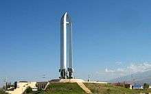
In August 1997, construction started on the "Iğdır Soykırım Anıt-Müzesi" (Iğdır Genocide Memorial and Museum). Turkish authorities erected the monument to commemorate massacres of Turks by Armenians during World War I and the Turkish–Armenian War during the Turkish War of Independence. The Turkish argument states that "A need was expressed for the erection of this monument and this opinion was stated as follows in the final declaration of the International Symposium on Historical Realities and Armenians, held in Iğdır from 24 to 26 April 1965. The Symposium resolved that a monument of martyrs should be erected in Iğdır and a cemetery for martyrs should be established in Oba Village in order to eternalise the memories of more than one million Turks that fell in Eastern Anatolia and to give a similar answer to those declaring 24 April as a genocide day and to the monuments erected in many places of the world for the alleged genocide perpetrated against the Armenians."[24]
It was opened on October 5, 1999 by Turkish Minister of State Ramazan Mirzaoğlu. Its height from ground level is 43.5 metres. The monument's design contains symbols related to Turkish self-identity, history, and legends. The upper structure consists of five upright swords, their points touching to resemble Mount Ararat. On the hilt of the swords are a series of reliefs. Beneath the monument are a series of rooms intended to house a museum. The granite for the monument's swords was brought from China and other materials, such as marble, granite, and ceramics, were brought from other regions of Turkey.[24]
Its construction is explained as a counter-argument by the Turks that Armenians also perpetrated massacres against Turks.[25]
Culture
Iğdır's culture is part of the larger culture of Turkey. The rising agricultural production and the opening of a border gate with Nakhchivan in 1992 have enabled the town to be livelier and wealthier than its neighbours in the generally impoverished eastern Turkey. There are many cafes and restaurants. The best-known dish is a meat stew called bozbaş.[26]
Media
Iğdır has 12 local daily and weekly newspapers.[27] The most prominent of these is Yeşil Iğdır which has been published since 1 September 1955.
Economy
The main economic activities in Iğdır are the commerce of agricultural and animal products.[17]
The city of Iğdır is located between Kars and Ağrı. Despite the fact that it has three strategically important neighbours, the border gate to Armenia is closed and there is no direct access to Iran, therefore this situation diminishes economic possibilities.
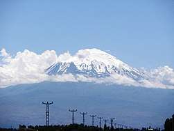
About 70% percent of Mount Ararat's area lies within Iğdır's borders, however the investments for developing tourism in Mt. Ararat is paid to Ağrı Municipality.
Demographics
According to the Russian family lists accounts from 1886, of the total 71,066 inhabitants of the districts 34,351 were Azerbaijanis (48.3%, mentioned as 'Tatars' in the source), 22,096 Armenians (31.1%) and 14,619 Kurds (20.6%).[9] According to the Russian Empire Census in 1897 Iğdır had a population of 4,680, of which 3,934 (84%) were Armenians, and 559 (12%) were Russians.[28]
Today, Iğdır has a mixed population of Azerbaijanis (who form the majority)[29][30]—Kurds and Turks.[31] The spring festival Nowruz is widely celebrated in Iğdır.
| Iğdır centrum population | |||
|---|---|---|---|
| 2007 | 75,927 | ||
| 2000 | 59,880 | ||
| 1997 | 44,334 | ||
| 1990 | 35,858 | ||
| 1985 | 29,460 | ||
| 1980 | 24,352 | ||
| 1975 | 29,542 | ||
| 1970 | 21,420 | ||
Transport
Transport to Iğdır is via roads or air. Iğdır Airport, opened in 2012, serves the city with internal flights to Istanbul and Ankara. Regular bus services connect the city to major national and regional centres. There is, as of 2016, no rail transport to Iğdır, but it will be a stop on the Nakhchivan-Kars railway when it is completed.[32]
Notable people
- Avetis Aharonian, Armenian politician
- Servet Çetin, Turkish national football team player of Azerbaijani descent
- Eduard Isabekyan, Armenian painter
- Drastamat Kanayan, Armenian military commander
- Sinan Oğan, Turkish politician;[33] won a seat in the Turkish parliament in 2011 with the right-wing Nationalist Movement Party[34]
- Şahin Yakut, Turkish kickboxer and MMA fighter
International relations
Twin towns — sister cities
Iğdır is twinned with:
Notes
- "Area of regions (including lakes), km²". Regional Statistics Database. Turkish Statistical Institute. 2002. Retrieved 2013-03-05.
- "Population of province/district centers and towns/villages by districts - 2012". Address Based Population Registration System (ABPRS) Database. Turkish Statistical Institute. Retrieved 2013-02-27.
- İbrahim Sediyani (2009). Adını arayan coğrafya. Özedönüş Yayınları. p. 187. ISBN 9786054296002.
- "IGDIR". Encyclopædia Iranica. 15 December 2004. Retrieved 14 October 2018.
- "Tarihi". igdir.gov.tr (in Turkish). TC Iğdır Valiliği. Retrieved 14 October 2018.
- (in Armenian) Anon. «Իգդիր» [Igdir]. Armenian Soviet Encyclopedia. Yerevan: Armenian Academy of Sciences, 1978, vol. 4, p. 309.
- Ruy González de Clavijo. The Broadway Travellers: Embassy to Tamerlane: 1403-1406. Trans. Guy le Strange. London: Routledge, 2004, p. 76.
- Sinclair, Thomas A. Eastern Turkey: An Architectural and Archaeological Survey, Volume 1. London: Pindar Press, 1987, p. 406-409.
- (in Russian) Свод статистических данных о населении Закавказского края, извлечённых из посемейных списков 1886 года. Tiflis, 1893.
- "ЭСБЕ/Игдырь — Викитека". ru.wikisource.org. Retrieved 2020-04-27.
- Hovannisian, Richard G. (1971). The Republic of Armenia: The First Year, 1918-1919, Vol. I. Berkeley: University of California Press. pp. 128–129. ISBN 0-520-01984-9.
- Chater, Melville. "The Land Of The Stalking Death: a Journey Through Starving Armenia on an American Relief Train." National Geographic 36 (November 1919). Retrieved July 24, 2009.
- Hovannisian. Republic of Armenia, Vol. I, p. 449, note 3.
- Hovannisian, Richard G. (1996). The Republic of Armenia, Vol. IV: Between Crescent and Sickle, Partition and Sovietization. Berkeley: University of California Press. pp. 249–250, 284. ISBN 0-520-08804-2.
- (in Turkish) Genelkurmay Askerî Tarih ve Stratejik Etüt Başkanlığı Yayınları, Türk İstiklâl Harbi IIIncü Cilt: Doğu Cephesi (1919-1921). Ankara: Genelkurmay Basım Evi, 1995, p. 221.
- British Documents on Foreign Affairs--Reports and Papers from the Foreign Office Confidential Print: From the First to the Second World War. The Soviet Union, 1917-1939, Volume 4, p. 388.
- "Iğdır". İslam Ansiklopedisi. 19. Türk Diyanet Vakfı. 1999. pp. 81–82.
- "Iğdır Seçim Sonuçları - 31 Mart 2019 Yerel Seçimleri". www.sabah.com.tr. Retrieved 2020-05-15.
- admin (2020-05-15). "A trustee has been appointed to 6 municipalities with HDP!". News1 English. Retrieved 2020-05-15.
- "Enver Ünlü". www.igdir.gov.tr. Retrieved 2020-05-15.
- "Archived copy". Archived from the original on 2011-04-30. Retrieved 2011-03-20.CS1 maint: archived copy as title (link)
- "Igdir, Turkey Travel Weather Averages (Weatherbase)". Weatherbase.
- Caravansarai of Zor. VirtualAni.org.
- "Igdir Genocide Monument and Museum."
- Hofmann, Tessa. "Armenians in Turkey: A Critical Assessment of the situation of the Armenian Minority in the Turkish Republic." Forum of Armenian Associations in Europe. October 2002, p. 32.
- "Sürmeli Çukurda Iğdır", Ziya Zakir Acar, 2002
- Her Yönüyle Iğdır", Ziya Zakir Acar, 2004
- (in Russian) Первая всеобщая перепись населения Российской Империи, 1897 г. (Erivanskaya Guberniya), N. A. Troynitskii, Saint Petersburg, 1904, p. 144.
- "Azerbaijanis Flock to Turkish Town". Institute for War and Peace Reporting. Institute for War and Peace Reporting. 9 November 2007.
A majority of Igdir’s 60,000 inhabitants are now Azerbaijani.
- Population policy in Turkey, Erhard Franz, page 293
- (in Turkish) Yilmaer, Esat. Sevilen valiyle ‘savaş’ MHP'ye kaybettirmiş." Hürriyet. August 5, 2002.
- "Iğdır'ın Sosyoekonomik Durumu" (PDF). Turkish Agency on the Development of Border Areas. Retrieved 12 December 2016.
- Head of Turkey-Azerbaijan association becomes deputy of Turkish parliament Archived 2014-10-27 at the Wayback Machine
- Azeri Elected to Turkish Parliament. Day.az. 13 June 2011.
External links
| Wikimedia Commons has media related to Iğdır. |
- Official website of the Iğdır Municipality
- (in Turkish) Official website of the Iğdır Province
- (in Turkish) Iğdır's news website
