Eastern Anatolia Region
The Eastern Anatolia Region (Turkish: Doğu Anadolu Bölgesi) is a geographical region of Turkey.
Eastern Anatolia Region Doğu Anadolu Bölgesi | |
|---|---|
Region of Turkey | |
| Country | Turkey |
| Area | |
| • Total | 165,436 km2 (63,875 sq mi) |
The region and the name "Doğu Anadolu Bölgesi" were defined at the First Geography Congress in 1941. It has the highest average altitude, largest geographical area, and lowest population density of the seven Turkish regions.
Kurdish people are the predominant ethnic group, and the region is considered part of Turkish Kurdistan. Until the 1915 Armenian Genocide, the region also had a large population of Armenians, and was known as Western Armenia.
Substitution with Armenia
Beginning in 1880, the name Armenia was forbidden to be used in official documents of the Ottoman Empire, in an attempt to play down the history of Armenians in their own homeland.[3][4][5] The government of Sultan Abdul Hamid II replaced the name Armenia with such terms as "Kurdistan" or "Anatolia". The Sublime Porte believed there would be no Armenian Question if there was no Armenia. The process of “nationalization” of toponyms was continued and gained momentum under the Kemalists after the foundation of the Republic of Turkey. In 1923, the entire territory of Western Armenia was officially renamed “Eastern Anatolia” (literally The Eastern East).[1][2][3][5]
The word Anatolia means “sunrise” or “east” in Greek. This name was given to the Asia Minor peninsula approximately in the 5th or 4th centuries B.C. During the Ottoman era, the term Anadolou included the north-eastern vilayets of Asia Minor, with Kyotahia as its center. Numerous European, Ottoman, Armenian, Russian, Persian, Arabic and other primary sources made clear distinctions between Anatolia and Armenia.[1] The Armenian Highlands have historically been considered to be east of Anatolia, with the border between them located near Sivas (Sebastia) and Kayseri (Caesarea).[4]
In the 17th century the terms "Anatolia" or "Eastern Anatolia" were never used to indicate Armenia. The Islamic World Map of the 16th century and other Ottoman maps of the 18th and 19th centuries also indicate Armenia (Ermenistan) in a specific territory, as well as its cities.[1]
Armenia, together with its boundaries, was mentioned in the works of Ottoman historians and chroniclers until the ban at the end of the 19th century. Kâtip Çelebi, a famous Ottoman chronicler of the 17th century, had a special chapter titled “About the Country Called Armenia” in his book Jihan Numa. However, when this book was republished in 1957, its modern Turkish editor H. Selen changed this title into “Eastern Anatolia”. Osman Nuri, a historian of the second half of the 19th century, mentions Armenia repeatedly in his three-volume Abdul Hamid and the Period of His Reign.[1]
Subdivision
Provinces
Provinces that are entirely in the Eastern Anatolia Region:
Provinces that are mostly in the Eastern Anatolia Region:
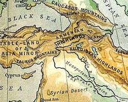
Location and borders
The Eastern Anatolia Region is located in the easternmost part of Turkey. It is bounded by Turkey's Central Anatolia Region to the west; Turkey's Black Sea Region to the north; Turkey's Southeast Anatolia Region and Iraq to the south; and Iran, Azerbaijan, Armenia and Georgia to the east, where Eastern Anatolia overlaps and converges with the South Caucasus region and Lesser Caucasus mountain plateau.
The area of the region is 146,330 km², which comprises 18.7% of the total area of Turkey.
Population
The total population of the region is 6,100,000 (2000 census) and 5,906,565 (2014 estimate). The region has the second most rural population of Turkey after the Black Sea region. The migration level (to the other regions, especially to Marmara Region) is high and population density (40 person/km²) is lower than the average for Turkey (98 person/km²). The migration toward other Turkey's regions and toward foreign countries is higher than the natural population increase, a fact which is leading to a slight decline of the Region's population.
Geography
The average altitude is 2,200 m. Major geographic features include plains, plateaus and massifs. There is some volcanic activity today.
Massifs and mountains
- There are three massif lines running north–south:
- To the north, the Çimen Dağı, Kop Dağı and Yalnızçam mountains
- In the centre, the Munzur, Karasu Dağı, Aras Dağı mountains
- To the south, Southeast Tauros, Bitlis, Hakkâri, and Buzul mountains.
- The volcanic mountains Nemrut, Süphan, Tendürek and Ararat are in the region.
Plateaus and plains
- The largest plateau in the region is Erzurum-Kars Plato.
- The region includes the Malatya, Elazığ, Bingöl, Muş plains and the Van Lake basin.
Lakes
Rivers
- Fırat
- Dicle
- Aras
- Kura
- Zap
Climate and nature
| Erzurum | ||||||||||||||||||||||||||||||||||||||||||||||||||||||||||||
|---|---|---|---|---|---|---|---|---|---|---|---|---|---|---|---|---|---|---|---|---|---|---|---|---|---|---|---|---|---|---|---|---|---|---|---|---|---|---|---|---|---|---|---|---|---|---|---|---|---|---|---|---|---|---|---|---|---|---|---|---|
| Climate chart (explanation) | ||||||||||||||||||||||||||||||||||||||||||||||||||||||||||||
| ||||||||||||||||||||||||||||||||||||||||||||||||||||||||||||
| ||||||||||||||||||||||||||||||||||||||||||||||||||||||||||||
Since most of the region is far from the sea, and has high altitude, it has a harsh continental climate with long winters and short summers. During the winter, it is very cold and snowy, during summer the weather is cool in the highlands and warm in the lowlands. The region has the lowest average temperature of all Turkish regions, with -25 °C. Although it can get below -40 °C. The summer average is about 20 °C.
The region's annual temperature difference is the highest in Turkey. Some areas in the region have different microclimates. As an example, Iğdır (near Mount Ararat) has a milder climate.
The region contains 11% percent of the total forested area of Turkey, and it is rich in native plants and animals. Oak and yellow pine trees form the majority of the forests.
The region has high potential for hydroelectric power.
Gallery
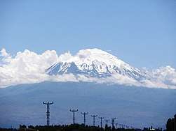 View of Mount Ararat from Iğdır
 Cumhuriyet Avenue, Erzurum.
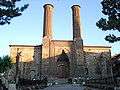 Çifte Minareli Medrese is an architectural monument of the late Seljuk period in the city of Erzurum
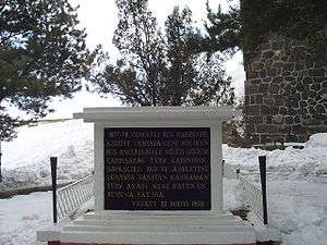 Monument of the Nene Hatun in the city of Erzurum
.JPG) Panoramic view of the city of Bingöl
Panoramic view of the city of Bingöl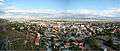 Panoramic view of the city of Kars
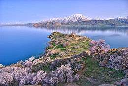 Akdamar Island and the Armenian Cathedral of the Holy Cross, a 10th-century Armenian church and monastic complex
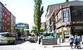 Kars city centre
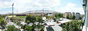
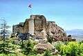 Harput Castle in Harpoot
Endnotes
- Sahakyan, Lusine (2010). Turkification of the Toponyms in the Ottoman Empire and the Republic of Turkey. Montreal: Arod Books. ISBN 978-0969987970.
- Hovannisian, Richard (2007). The Armenian Genocide: Cultural and Ethical Legacies. New Brunswick, N.J.: Transaction Publishers. p. 3. ISBN 1412835925.
- Cheterian, Vicken (2015). Open Wounds: Armenians, Turks and a Century of Genocide. Oxford and New York City: Oxford University Press. p. 65. ISBN 1849044589.
As a result of policies such as these, the expression Armenian Plateau, which had been used for centuries to denote the mountainous highlands around Lake Van and Lake Sevan, was eliminated and replaced by the expression 'eastern Anatolia'.
- Galichian, Rouben (2004). Historic Maps of Armenia: The Cartographic Heritage. London and New York City: I.B. Tauris. p. 8-9. ISBN 1860649793.
- Journal of the Society for Armenian Studies. 14-16. Los Angeles. 2005. p. 55.
Most of historical Armenia presently constitutes a part of Turkey (renamed "Eastern Anatolia"), which conducts a policy of minimizing the role of the Armenians in history
- "Archived copy". Archived from the original on 2011-06-20. Retrieved 2011-05-31.CS1 maint: archived copy as title (link)
External links
| Wikivoyage has a travel guide for Eastern Anatolia. |