Hosur Road
Bangalore-Hosur Road is the part of National Highway 48, erstwhile NH7, which connects metropolis Bangalore and business town Hosur. It is a four to eight-lane access controlled highway. The road is part of the National Highway network.
| Hosur Road | |
|---|---|
 | |
| Route information | |
| Maintained by NHAI, BBMP, BDA | |
| Length | 32.00 km (19.88 mi) |
| Major junctions | |
| North end | Brigade Road |
| Outer Ring Road, Bannerghatta Road | |
| South end | Attibele, Anekal Taluk. |
| Location | |
| States | Karnataka |
| Highway system | |
The National Highways Authority of India has constructed a 10-kilometer-long elevated highway from Madiwala to Electronics City. The Bruhat Bengaluru Mahanagara Palike and Bangalore Development Authority have planned a series of flyovers and underpasses to make this arterial road signal free.[1] The project is a part of the BETL (Bangalore Elevated Tollways Ltd), project as part of the National Highways Development Project and the Elevated Highways Project. It was initiated in early 2006, and was inaugurated on 22 January 2010.[2] It starts from Bomanahalli after the Central Silk Board flyover and goes on up to Electronics City. It goes above the BMIC flyover on Hosur Road, at a height of 17 meters (56 ft), thus making it, Bangalore's tallest flyover.[3]
See also
- NICE Road
- Outer Ring Road
- Inner Ring Road, Bangalore
Gallery
 Bangalore elevated tollway on Bangalore-Hosur road.
 Bangalore elevated tollway on Bangalore-Hosur road NH7
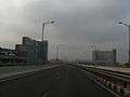 Eway near Bosch
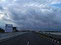 Bangalore Elevated Tollway
 EC eway Up ramp
References
- Manasi (27 October 2009). "Hosur Road widening is in full swing". Bangalore: Bangalore Mirror. Archived from the original on 29 August 2012. Retrieved 27 March 2011.
- "Expressway Elevates Commuting". Deccan Herald.
- Sowmya Aji Mehu (9 September 2005). "56-foot-high highway to fly over BMIC road". Bangalore: Times of India. Retrieved 31 March 2011.