Begur, Bangalore
Begur is in town the Indian state of Karnataka. It is in the state capital Bengaluru. It is off Bengaluru-Hosur highway. It is said to have been a prominent place during the rule of the Western Ganga Dynasty and later the Chola Kingdom.
Beguru DoddaBeguru | |
|---|---|
Town | |
 Beguru Location in Bengaluru, India | |
| Coordinates: 12.872347°N 77.632871°E | |
| Country | |
| State | Karnataka |
| Metro | Bengaluru |
| Languages | |
| • Official | Kannada |
| Time zone | UTC+5:30 (IST) |
| PIN | 560068 |
Begur Fort
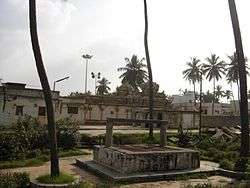
Panchalingeshwara temple is located in the centre of Begur. It has a 1100 years old inscription which is the oldest existing reference to a place called 'Bengaluru'. The area was ruled by the Western Ganga Dynasty and in the 10th century the Cholas had acquired the territory.
The Nageshwara temple was built by Ereganga Neetimarga around 9th century and Panchaligeshwara temple was built by Akthiyar of the Chola Kingdom.
Near the temple, there exists a tiny circular fort, about 1.4 km² in area, is built by the Cholas. The date of construction is unknown (no research done), but the existence of a 1100-year-old inscription on the gateway of the fort would suggest the same age for the fort.
Transport
BMTC buses plying between Begur and KR Market/Shivaji Nagar/Kempegowda Bus Stand. Marco Polo AC buses to Shivaji Nagar travel from Vishwapriya Nagara. This suburb which is along the Major Outer Ring Road and proximate to National highway which connects Hosur a border of neighbour state Tamil Nadu. Bangalore Airport and railway station are conveniently reachable with the available Outer Ring Road (ORR) passing through this Area along with availability of frequent BMTC buses to and fro between Begur and Centre part of the city.
| Wikimedia Commons has media related to Begur, Bangalore. |
District HQ: Bangalore | |
| Villages and Towns |
|