Highland Mountains
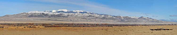
The Highland Mountains, highest point Table Mountain, el. 10,223 feet (3,116 m),[1] are a small mountain range southwest of Whitehall, Montana in Silver Bow and Madison County, Montana.
| Highland Mountains | |
|---|---|
 Highland Mountains Location in Montana | |
| Highest point | |
| Peak | Table Mountain |
| Elevation | 10,223 ft (3,116 m) |
| Coordinates | 45°43′34″N 112°28′44″W |
| Geography | |
| Country | United States |
| State | Montana |
The Continental Divide winds through the range. A 21,000-acre roadless area encompasses the core of the range, which includes Red Mountain, also over 10,000'.[2] Nutritious alpine forage in the Highlands gives area bighorn sheep the fastest horn growth of any herd in Montana.[2] The green-tinted waters of Emerald Lake provide a nice contrast to the red rock of Red Mountain.[2] A smaller roadless area of about 10,000 acres in the Basin Creek drainage protects Butte's municipal watershed.[2] Lodgepole pine and Douglas-fir are common tree species.[2]
See also
Notes
- Recreational Map of Western Montana. Canon City, CO: Western GeoGraphics. 1990. pp. n/a. ISBN 0-528-92551-2.
- Cunningham, Bill (1990). Montana Wildlands. Helena, MT: American Geographic Publishing. p. 60. ISBN 0-938314-93-9.
This article is issued from Wikipedia. The text is licensed under Creative Commons - Attribution - Sharealike. Additional terms may apply for the media files.