Table Mountain (Madison County, Montana)
Table Mountain, el. 10,213 feet (3,113 m) is the highest peak in the Highland Mountains in Madison County, Montana. It is located in Beaverhead-Deerlodge National Forest. Headwaters of Moose Creek, Fish Creek and Hell's Canyon Creek, all significant tributaries of the Jefferson River flow off the face of the mountain.
| Table Mountain | |
|---|---|
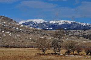 Table Mountain, Hell's Canyon Face (East) | |
| Highest point | |
| Elevation | 10,213 feet (3,113 m) |
| Prominence | 4,422 feet (1,348 m)[1] |
| Isolation | 19.3 miles (31.1 km) |
| Coordinates | 45°44′32″N 112°27′43″W[2] |
| Geography | |
 Table Mountain | |
| Parent range | Highland Mountains |
See also
Notes
- "Table Mountain". Peakbagger.com. Retrieved 2015-01-26.
- "Table Mountain". Geographic Names Information System. United States Geological Survey.
This article is issued from Wikipedia. The text is licensed under Creative Commons - Attribution - Sharealike. Additional terms may apply for the media files.