al-Judeira
al-Judeira (Arabic: جديره) is a Palestinian village in the Jerusalem Governorate in the central West Bank.
Al-Judeira | |
|---|---|
| Arabic transcription(s) | |
| • Arabic | جديره |
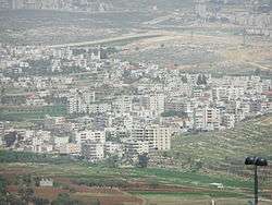 al-Judeira in the front of the picture. | |
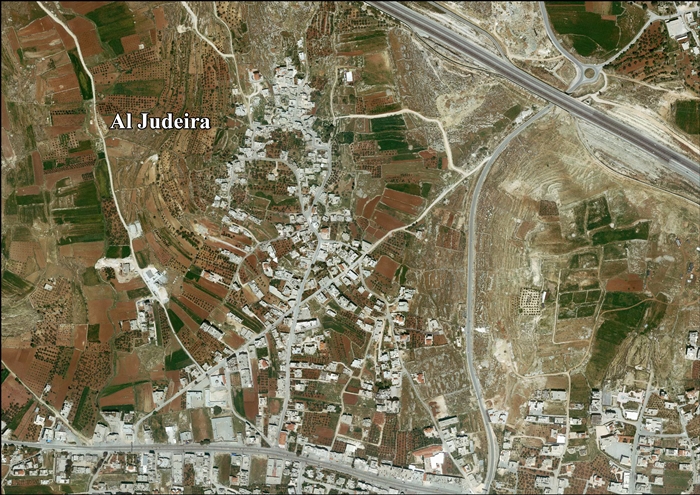
 Al-Judeira Location of Al-Judeira within Palestine | |
| Coordinates: 31°51′30″N 35°11′52″E | |
| Palestine grid | 168/140 |
| State | State of Palestine |
| Governorate | Jerusalem |
| Government | |
| • Type | Village council |
| Population (2006) | |
| • Total | 2,121 |
| Name meaning | The sheep-fold[1] |
According to the Palestinian Central Bureau of Statistics, the town had a population of 2,121 in 2006.[2]
Location

Al Judeira is located (horizontally) 9.3 kilometers (5.8 mi) north-west of Jerusalem. To the east is Kalandia, Rafat is to the north, Al Jib is to the west, and Bir Nabala is to the south.[3]
History
Ottoman era
In the Ottoman census of the 1500s, Jadira was noted as a village located in the nahiya of Jerusalem.[4]
In 1838 el-Jedireh was noted as a Muslim village, located north of Jerusalem.[5][6]
In 1863 Guérin described it as a small village, with a mosque consecrated to a Sheikh Yassin. In the courtyard in front of this sanctuary, he noticed what was possibly an old Corinthian capital, which had been made into a mortar, where the villagers pounded coffee.[7] An Ottoman village list from about 1870 found that the village had a population of 40, in a total of 13 houses, though the population count only included men. It was also noted that it was located east of Al Jib.[8][9]
In 1883, the PEF's Survey of Western Palestine (SWP) described it as "a small village on a slope, surrounded by figs and olives, and with rock-cut tombs to the north."[10]
British Mandate era
In the 1922 census of Palestine conducted by the British Mandate authorities, Ijdireh had a population of 122, all Muslims,[11] increasing in the 1931 census to 139 Muslim inhabitants, in 31 inhabited houses.[12]
In the 1945 statistics Judeira had a population of 190 Muslims,[13] with 2,044 dunams of land, according to an official land and population survey.[14] Of this, 353 dunams were plantations and irrigable land, 1,314 used for cereals,[15] while 7 dunams were built-up (urban) land.[16]
Jordanian era
In the wake of the 1948 Arab–Israeli War, and after the 1949 Armistice Agreements, al-Judeira came under Jordanian rule.
The Jordanian census of 1961 found 328 inhabitants in Judeira.[17]
Post-1967
Since the Six-Day War in 1967, al-Judeira has been under Israeli occupation.
After the 1995 accords, 25.4% of the village’s land was classified as Area B, the remaining 74.6% is classified was Area C.[18]
In 2005, Israel started the construction of a separation barrier around al-Judeira, Al Jib, Bir Nabala, Beit Hanina al-Balad and Kalandiya.[19] The wall was built on Palestinian land seized by Military Orders.[20] The wall completely surrounds the villages, forming an enclave.[21]
References
- Palmer, 1881, p. 296
- Projected Mid -Year Population for Jerusalem Governorate by Locality 2004- 2006 Archived 2012-02-07 at the Wayback Machine Palestinian Central Bureau of Statistics.
- Al Judeira Village Profile, ARIJ, p. 4
- Toledano, 1984, p. 294, has Jadira at location 35°11′35″E 31°51′35″N.
- Robinson and Smith, 1841, vol 3, Appendix 2, p. 122
- Robinson and Smith, 1841, vol 2, p. 137
- Guérin, 1868, p. 392
- Socin, 1879, p. 153
- Hartmann, 1883, p. 127, noted 17 houses
- Conder and Kitchener, 1883, SWP III, pp. 9 10
- Barron, 1923, Table VII, Sub-district of Jerusalem, p. 15
- Mills, 1932, p. 40
- Government of Palestine, Department of Statistics, 1945, p. 25
- Government of Palestine, Department of Statistics. Village Statistics, April, 1945. Quoted in Hadawi, 1970, p. 57 Archived 2011-06-04 at the Wayback Machine
- Government of Palestine, Department of Statistics. Village Statistics, April, 1945. Quoted in Hadawi, 1970, p. 103 Archived 2016-03-03 at the Wayback Machine
- Government of Palestine, Department of Statistics. Village Statistics, April, 1945. Quoted in Hadawi, 1970, p. 153 Archived 2016-03-03 at the Wayback Machine
- Government of Jordan, Department of Statistics, 1964, p. 23
- Al Judeira Village Profile, ARIJ, p. 17
- High Court approves Bir Nabalah enclave. B'Tselem, 26 November 2006
- Israel’s Segregation Wall Encircles Three Palestinian Villages in Northwest Jerusalem Archived 2007-06-02 at the Wayback Machine ARIJ, 7 May 2005
- "West Bank Closures - Jerusalem" (PDF). United Nations Office for the Coordination of Humanitarian Affairs. March 2004. Archived from the original (PDF) on 2007-10-14. Retrieved 2007-10-14.
Bibliography
- Barron, J. B., ed. (1923). Palestine: Report and General Abstracts of the Census of 1922. Government of Palestine.
- Conder, C.R.; Kitchener, H.H. (1883). The Survey of Western Palestine: Memoirs of the Topography, Orography, Hydrography, and Archaeology. 3. London: Committee of the Palestine Exploration Fund. (p. 43)
- Government of Jordan, Department of Statistics (1964). First Census of Population and Housing. Volume I: Final Tables; General Characteristics of the Population (PDF).
- Government of Palestine, Department of Statistics (1945). Village Statistics, April, 1945.
- Guérin, V. (1868). Description Géographique Historique et Archéologique de la Palestine (in French). 1: Judee, pt. 1. Paris: L'Imprimerie Nationale.
- Hadawi, S. (1970). Village Statistics of 1945: A Classification of Land and Area ownership in Palestine. Palestine Liberation Organization Research Center. Archived from the original on 2018-12-08. Retrieved 2016-01-02.
- Hartmann, M. (1883). "Die Ortschaftenliste des Liwa Jerusalem in dem türkischen Staatskalender für Syrien auf das Jahr 1288 der Flucht (1871)". Zeitschrift des Deutschen Palästina-Vereins. 6: 102–149.
- Mills, E., ed. (1932). Census of Palestine 1931. Population of Villages, Towns and Administrative Areas. Jerusalem: Government of Palestine.
- Palmer, E.H. (1881). The Survey of Western Palestine: Arabic and English Name Lists Collected During the Survey by Lieutenants Conder and Kitchener, R. E. Transliterated and Explained by E.H. Palmer. Committee of the Palestine Exploration Fund.
- Robinson, E.; Smith, E. (1841). Biblical Researches in Palestine, Mount Sinai and Arabia Petraea: A Journal of Travels in the year 1838. 2. Boston: Crocker & Brewster.
- Robinson, E.; Smith, E. (1841). Biblical Researches in Palestine, Mount Sinai and Arabia Petraea: A Journal of Travels in the year 1838. 3. Boston: Crocker & Brewster.
- Socin, A. (1879). "Alphabetisches Verzeichniss von Ortschaften des Paschalik Jerusalem". Zeitschrift des Deutschen Palästina-Vereins. 2: 135–163.
- Toledano, E. (1984). "The Sanjaq of Jerusalem in the Sixteenth Century: Aspects of Topography and Population". Archivum Ottomanicum. 9: 279–319.
External links
- Welcome To Judayra
- Survey of Western Palestine, Map 17: IAA, Wikimedia commons
- Al Judeira Village (Fact Sheet), Applied Research Institute–Jerusalem (ARIJ)
- Al Judeira Village Profile, ARIJ
- Al Judeira area photo, ARIJ
- Locality Development Priorities and Needs in Al Judeira, ARIJ
Jerusalem Governorate | ||
|---|---|---|
| Cities |  | |
| Municipalities | ||
| Villages | ||
| Refugee camps | ||