Hadera Stream
Hadera Stream (Hebrew: נחל חדרה, romanized: Nahal Hadera), also known as Nahr Mufjir (Arabic: نهر المفجر) and previously also as Nahr Akhdar (Arabic: نهر الأخضر, lit. 'green river'),[1] is a seasonal watercourse in Israel.
The Crusaders called it the "Dead River" due to its sluggish character.[2]
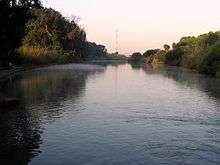
Nahal Hadera flows from the highlands in the northern West Bank and empties into the Mediterranean Sea at Hadera. The Hadera Water Park, located between Givat Olga and the power plant, is a 750-dunam park that holds a 40-metre-wide creek banked by a 1.3-km-long promenade.[3] A dam is being constructed where the water park meets the Coastal Highway and is supposed to prevent the rehabilitated section of the stream from being polluted by water from the watercourse itself.[4]
References
- Trelawney Saunders (1881). An Introduction to the Survey of Western Palestine: its Waterways, Plains, & Highlands. London: Richard Bentley and Son. pp. 24, 32–33.
- Claude R. Conder (29 January 1875). "XXXI. Mediæval Topography of Palestine.". Quarterly Statement for 1875. London: Palestine Exploration Fund. p. 91.
- Ashkenazy, Daniella (2008-09-17). "Hadera's lost lagoons". The Jerusalem Post. Retrieved 2009-04-07.
- Ashkenazy, Daniella (2008-09-17). "Restoration of Nahal Hadera - more than a half-full cup". The Jerusalem Post. Retrieved 2009-04-07.