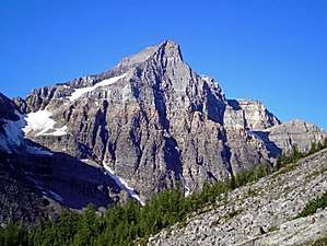
Haddo Peak
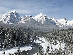
Haddo Peak is a summit in Alberta, Canada.[3] Haddo Peak is located in the Lake Louise area of Banff National Park.
| Haddo Peak | |
|---|---|
 Haddo Peak | |
| Highest point | |
| Elevation | 3,070 m (10,070 ft) [1] |
| Prominence | 83 m (272 ft) [1] |
| Parent peak | Mount Aberdeen (3157 m)[2] |
| Listing | Mountains of Alberta |
| Coordinates | 51°23′00″N 116°14′12″W [3] |
| Geography | |
 Haddo Peak Location of Haddo Peak in Alberta  Haddo Peak Haddo Peak (Canada) | |
| Location | Alberta, Canada |
| Parent range | Bow Range Canadian Rockies |
| Topo map | NTS 82N/08[3] |
| Type of rock | Sedimentary |
| Climbing | |
| First ascent | 1903 by E. Tewes, C. Bohren[1] |
| Easiest route | Technical climb via Southwest Ridge |
Haddo Peak honors the name of George Gordon, Lord Haddo.[4] Named in 1916, the name became official in 1952.
Geology
Like other mountains in Banff Park, Haddo Peak is composed of sedimentary rock laid down from the Precambrian to Jurassic periods.[5] Formed in shallow seas, this sedimentary rock was pushed east and over the top of younger rock during the Laramide orogeny.[6]
Climate
Based on the Köppen climate classification, Haddo Peak is located in a subarctic climate with cold, snowy winters, and mild summers.[7] Temperatures can drop below -20 °C with wind chill factors below -30 °C. Weather conditions during summer months are optimum for climbing.
External links
- Parks Canada web site: Banff National Park
References
- "Haddo Peak". Bivouac.com. Retrieved 2018-10-14.
- "Haddo Peak, Alberta". Peakbagger.com. Retrieved 2019-09-20.
- "Haddo Peak". Geographical Names Data Base. Natural Resources Canada. Retrieved 2018-10-17.
- Place-names of Alberta. Ottawa: Geographic Board of Canada. 1928. p. 61.
- Belyea, Helen R. (1960). The Story of the Mountains in Banff National Park (PDF). parkscanadahistory.com (Report). Ottawa: Geological Survey of Canada. Archived (PDF) from the original on 2015-10-02. Retrieved 2019-09-13.
- Gadd, Ben (2008). "Geology of the Rocky Mountains and Columbias". Missing or empty
|url=(help) - Peel, M. C.; Finlayson, B. L. & McMahon, T. A. (2007). "Updated world map of the Köppen−Geiger climate classification". Hydrol. Earth Syst. Sci. 11: 1633–1644. ISSN 1027-5606.