Gungahlin
The District of Gungahlin is one of the original eighteen districts of the Australian Capital Territory used in land administration. Gungahlin Region is one of fastest growing regions within Australia. The district is subdivided into divisions (suburbs), sections and blocks. Gungahlin is an Aboriginal word meaning either "white man's house" or "little rocky hill".[4]
| Gungahlin Australian Capital Territory | |||||||||||||||
|---|---|---|---|---|---|---|---|---|---|---|---|---|---|---|---|
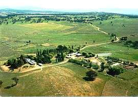 Gold Creek was typical of the sheep properties of the Gungahlin region prior to development. | |||||||||||||||
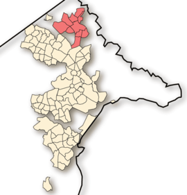 Location of Gungahlin, shaded. | |||||||||||||||
| Coordinates | 35.1831°S 149.133°E | ||||||||||||||
| Population | 70,871 (2016 census)[1][2] | ||||||||||||||
| • Density | 782.2/km2 (2,026.0/sq mi) | ||||||||||||||
| Gazetted | 12 May 1966[3] | ||||||||||||||
| Area | 90.6 km2 (35.0 sq mi) | ||||||||||||||
| Location | 10 km (6 mi) N of Canberra City | ||||||||||||||
| Parish | Holy Spirit Catholic Parish, Amaroo | ||||||||||||||
| Territory electorate(s) | Yerrabi | ||||||||||||||
| Federal Division(s) | Fenner | ||||||||||||||
| |||||||||||||||
As of 2013 Gungahlin comprised eleven suburbs, including three currently under construction and a further seven suburbs planned. The town of Gungahlin was part of the original 1957 plan for future development in the ACT and in 1991 was officially launched as Canberra's fourth ‘town’ by the ACT Chief Minister. At the time, the population of Gungahlin was just 389 residents. According to the 2016 census, the population of the district was 70,871,[1][2] a increase from 46,971 in the 2011 census.[5][6] This figure is expected to rise to 83,167 by the year 2020.[7]
Within the district is Canberra's northernmost town centre that is situated 10 kilometres (6.2 mi) north of Canberra city centre. The town centre is one of five satellites of Canberra, seated in Woden, Tuggeranong, Weston Creek and Belconnen.
Establishment and governance
The traditional custodians of the district are the indigenous people of the Ngunnawal tribe.[8]
Following the transfer of land from the Government of New South Wales to the Commonwealth Government in 1911, the district was established in 1966 by the Commonwealth via the gazettal of the Districts Ordinance 1966 (Cth) which, after the enactment of the Australian Capital Territory (Self-Government) Act 1988,[9] became the Districts Act 1966.[10] This Act was subsequently repealed by the ACT Government and the district is now administered subject to the Districts Act 2002.[11]
During colonial times and up until the late 1960s, present-day Gungahlin was part of the former farmlands of Ginninderra. Ginninderra Village and later still the village of Hall serviced the needs of the local farming community. Free settlers included farming families such as the Rolfe, Shumack, Gillespie and Gribble families.[12] These settlers established wheat and sheep properties such as 'Weetangara', 'Gold Creek', 'The Valley', 'Horse Park' and 'Tea Gardens'. Much of the local produce supplied the large workforce at goldfields located at Braidwood and Major's Creek in New South Wales.[13]
Location and urban structure
The district is a set of contiguous residential and industrial suburbs that surround a town centre, together with undeveloped pastoral leases that border with the state of New South Wales to the north, north-east and east. The suburbs are divided from the surrounding districts of Belconnen to the west and south-west, Canberra Central to the south, Majura to the south-east, and Hall to the north-west.
The main industrial suburb of the district is Mitchell.
Churches and Schools
Churches:
There are many religious organisations and churches located in Gungahlin.
Gungahlin Uniting Church is located on 108, The Valley Avenue.
Gungahlin Anglican Church is located at the Grace Chapel at the Valley Avenue
Forde Anglican Church is located at Chiesa Street, Forde.
The Salvation Army Church is located on 104 The Valley Avenue.
Every Nation Community Parish is located inside The Salvation Army Church Building.
Cornerstone Christian Church is located inside The Salvation Army Church Building.
Gungahlin Mosque is located on 140, The Valley Avenue.
Schools: Gungahlin College is located on 23 Gozzard Street. Burgmann Anglican School is located on 4, The Valley Avenue.
Demographics
At the 2011 census, there were 46,971 people in the Gungahlin district, of these 49.4 per cent were male and 50.6 per cent were female. Aboriginal and Torres Strait Islander people made up 1.2 per cent of the population, which was lower than the national and territory averages. The median age of people in the Gungahlin district was 31 years, which was significantly lower than the national median of 37 years. Children aged 0 – 14 years made up 24.6 per cent of the population and people aged 65 years and over made up 4.7 per cent of the population. Of people in the area aged 15 years and over, 54.8 per cent were married and 9.1 per cent were either divorced or separated.[5]
Population growth in the Gungahlin district between the 2001 census and the 2006 census was 35.6 per cent; and in the subsequent five years to the 2011 census, population growth was in excess of 51 per cent. When compared with total population growth of Australia for the same periods, being 5.78 per cent and 8.32 per cent respectively, population growth in Gungahlin district was significantly higher than the national average.[14][15] The median weekly income for residents within the Gungahlin district was nearly double the national average, and slightly higher than the territory average.[5]
At the 2011 census, the proportion of residents in the Gungahlin district who stated their ancestry as Australian or Anglo-Saxon exceeded 70 per cent of all residents (national average was 65.2 per cent). In excess of 40 per cent of all residents in the Gungahlin district nominated a religious affiliation with Christianity at the 2011 census, which was lower than the national average of 50.2 per cent. Meanwhile, as at the census date, compared to the national average, households in the Gungahlin district had a significantly higher than average proportion (31.4 per cent) where two or more languages are spoken (national average was 20.4 per cent); and a slightly lower proportion (69 per cent) where English only was spoken at home (national average was 76.8 per cent).[5]
| Selected historical census data for the Gungahlin district | |||||
|---|---|---|---|---|---|
| Census year | 2001[14][16] | 2006[15][17] | 2011[5][6] | ||
| Population | Estimated residents on census night | 23,098 | 31,318 | 46,971 | |
| District rank in terms of size within the Australian Capital Territory | 5th | ||||
| Percentage of the Australian Capital Territory population | 13.15% | ||||
| Percentage of the Australian population | 0.12% | ||||
| Cultural and language diversity | |||||
| Ancestry, top responses | Australian | 25.6% | |||
| English | 21.1% | ||||
| Irish | 7.1% | ||||
| Scottish | 5.6% | ||||
| Chinese | 5.2% | ||||
| Language, top responses (other than English) | Mandarin | 1.2% | |||
| Vietnamese | 2.1% | ||||
| Cantonese | 1.7% | ||||
| Croatian | 3.0% | ||||
| Hindi | n/c | n/c | |||
| Religious affiliation | |||||
| Religious affiliation, top responses | Catholic | 33.0% | |||
| No Religion | 16.0% | ||||
| Anglican | 17.1% | ||||
| Buddhism | 3.5% | ||||
| Hinduism | n/c | n/c | |||
| Median weekly incomes | |||||
| Personal income | Median weekly personal income | A$813 | A$1,019 | ||
| Percentage of Australian median income | 174.5% | ||||
| Family income | Median weekly family income | A$1,836 | A$2,355 | ||
| Percentage of Australian median income | 156.8% | ||||
| Household income | Median weekly household income | A$1,676 | A$2,176 | ||
| Percentage of Australian median income | 163.2% | ||||
List of suburbs
|
|
|
|
|
Asterisk indicates undeveloped suburbs as of 2018.
Transport
The primary mode of transport within the district is by private vehicle. Despite continued discussion about the preference for sustainable public transport especially light rail, Gungahlin's development is still guided by a philosophy of reliance on private personal transport and an extensive road network.
Public transport
Bus
The ACTION bus service provides public transport throughout Canberra. Services from the various suburbs generally pass through a bus interchange located at the Gungahlin Town Centre from where they connect with light rail to Civic. Some services operate direct to the Belconnen Town Centre. The Gungahlin bus interchange is located in Hibberson Street.
Light rail
A light rail network linking the Gungahlin Town Centre to Civic opened in April 2019. It is intended to address peak-hour congestion on Northbourne Avenue by encouraging public transport use.[18]
Private transport
Private transport is the dominant mode of transport for Gungahlin commuters. The district's major arterial roads to North Canberra and the city centre are Northbourne Avenue via the Barton Highway, Horse Park Drive and Flemington Road. Gundaroo Drive-William Slim Drive is the main connection to the district of Belconnen. With the completion of the Gungahlin Drive Extension in 2008, Gungahlin commuters can bypass the city centre to reach city's southern suburbs via Gungahlin Drive and onto William Hovell Drive and the Tuggeranong Parkway.
A number of projects have improved road access to the Gungahlin district including:
- Duplication of the remaining single lane sections of the Gungahlin Drive Extension (completed 2011).
- Clarrie Hermes Drive extension to the Barton Highway (completed May 2012).
- Flemington Road was upgraded to a dual carriage way between Gungahlin Town Centre and Wells Station Road in 2010. Although this has provided some benefit for travellers, the road is mostly still one lane each way between Well Station Drive at Harrison and the intersection at Northbourne Avenue. This has created major traffic jams on the road, especially in the morning peak hour.
Public facilities
While the Gungahlin district is serviced by Calvary Hospital and The Canberra Hospital for emergency treatment, a number of private medical practices have established in the town centre and surrounding suburbs. The ACT Government Health Directorate also operates a Community Health Centre, providing access to allied health and outpatient services including mental health services, children's dental and nutrition, diabetes clinic, pathology collection and drug and alcohol counseling services. The clinic opened on 3 September 2012.[19]
The Australian Capital Territory Emergency Services Agency operates the Gungahlin Joint Emergency Services Centre which provides the Gungahlin district with a local operations centre for Ambulance and Police as well as ACT Fire and Rescue and the Rural Fire Service.
Community and sports organisations
The Gungahlin Community Council is the peak community representative organisation for the district.
Gungahlin local sport teams include the Gungahlin Eagles (rugby union), the Gungahlin Bulls (rugby league), Gungahlin United (association football) and the Gungahlin Jets (Australian rules football). All four clubs play matches at Gungahlin Enclosed Oval. Gungahlin is also represented in the ACT Cricket Association by the North Canberra Gungahlin Cricket Club.
Schools
References
- Australian Bureau of Statistics (27 June 2017). "Gungahlin (SA3)". 2016 Census QuickStats. Retrieved 19 January 2018.

- Australian Bureau of Statistics (27 June 2017). "Hall (SSC)". 2016 Census QuickStats. Retrieved 1 July 2017.
- "Districts Ordinance 1966 (ACT)" (PDF).
- Search for street and suburb names - Environment, Planning and Sustainable Development Directorate - Planning
- Australian Bureau of Statistics (31 October 2012). "Gungahlin (SA3)". 2011 Census QuickStats. Retrieved 20 December 2013.
- Australian Bureau of Statistics (31 October 2012). "Hall (SLA)". 2011 Census QuickStats. Retrieved 20 December 2013.
- Chief Minister, Treasury and Economic Development Directorate (March 2017). ACT Population Projections 2017 to 2020 (pdf) (Report). Canberra: ACT Government. p. 27. Retrieved 19 January 2018.
- "Aboriginal Heritage in the ACT". Heritage. Environment and Sustainable Development Directorate. 17 March 2013. Archived from the original on 19 December 2013. Retrieved 18 December 2013.
- Australian Capital Territory (Self-Government) Act 1988 (Cth)
- Districts Act 1966 (ACT).
- Districts Act 2002 (ACT).
- Shumack, S (1977). Tales and legends of Canberra pioneers. Canberra: Australian National University.
- Newman, Chris (2004). Gold Creek, Reflections of Canberra's Rural Heritage. Canberra: Gold Creek Homestead Working Group.
- Australian Bureau of Statistics (9 March 2006). "Gungahlin-Hall (SSD)". 2001 Census QuickStats. Retrieved 20 December 2013.
- Australian Bureau of Statistics (25 October 2007). "Gungahlin-Hall (SSD)". 2006 Census QuickStats. Retrieved 20 December 2013.
- Australian Bureau of Statistics (9 March 2006). "Hall (SLA)". 2001 Census QuickStats. Retrieved 20 December 2013.
- Australian Bureau of Statistics (25 October 2007). "Hall (SLA)". 2006 Census QuickStats. Retrieved 20 December 2013.
- "Capital Metro". ACT Government. Retrieved 16 January 2014.
- "Gungahlin Community Health Centre". ACT Government. Retrieved 16 January 2014.
External links
- ACTMAPi - the ACT Government's interactive mapping service