Monash, Australian Capital Territory
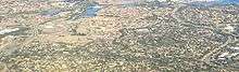
Monash (postcode 2904) is a suburb in the district of Tuggeranong, Canberra, Australia. The suburb is named after General Sir John Monash, (1865 to 1931), who commanded the Australian Army in France in the First World War.[2] It was gazetted on 1 August 1975[2] and first settled in 1978. The suburb has an area of 3.41 km². Streets are named after engineers[2] and the suburb consists primarily of detached houses on suburban blocks.
| Monash Canberra, Australian Capital Territory | |||||||||||||||
|---|---|---|---|---|---|---|---|---|---|---|---|---|---|---|---|
 | |||||||||||||||
| Coordinates | 35°25′01″S 149°06′00″E | ||||||||||||||
| Population | 5,431 (2016 census)[1] | ||||||||||||||
| • Density | 1,597/km2 (4,140/sq mi) | ||||||||||||||
| Established | 1978 | ||||||||||||||
| Gazetted | 5 August 1975 | ||||||||||||||
| Postcode(s) | 2904 | ||||||||||||||
| Area | 3.4 km2 (1.3 sq mi) | ||||||||||||||
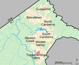
| District | Tuggeranong | ||||||||||||||
| Federal Division(s) | Bean | ||||||||||||||
| |||||||||||||||
The suburb is bounded by Erindale Drive, Drakeford Drive, Isabella Drive and Ashley Drive. Located in the suburb is Isabella Pond and part of the Tuggeranong Creek. Facilities include the Goodwin Retirement Village, a primary school and a recreation oval. Monash is serviced by a small local shopping centre, the larger Erindale Shopping Centre at Wanniassa and the nearby Tuggeranong Hyperdome.
Demographics
At the 2016 census, Monash had a population of 5,431 people. The median age of people in Monash was 43 years, above the ACT average of 35. The median individual income was $931 per week compared to $998 per week across the ACT, while the median household income was $1,978. In 2016, the median monthly housing loan repayment in Monash was $1,964, compared to the ACT average of $2,058.[1]
The residents of Monash are predominantly Australian born, with 70.2% being born in Australia. The three main countries of birth for those born overseas were England, 3.5%, India, 2.4%, Vietnam, 1.2%, Sri Lanka, 1.2% and New Zealand, 1.1%. The most popular religious affiliations in descending order are no religion, Catholic, Anglican and Uniting.[1]
Geology
Deakin Volcanics green grey, purple and cream rhyolite is in the west of the suburb and Deakin Volcanics green grey and purple rhyodacite occurs in the center and east. These rocks are from the Silurian period around 414 million years old.[3]
Amenities
Monash Primary School
Monash Primary School, on Corlette Crescent, is a preschool to Year 6 ACT public school. The school's motto is 'Touch the earth, reach the sky, challenge the future'. Monash Primary uses the Walker Learning Approach of play-based and personalised learning. The school has a kitchen garden program, band and many other opportunities for enrichment.
Canberra Islamic Centre

Monash is also home to the Canberra Islamic Centre and Australian National Islamic Library, first opened in 1993.[4] The Centre, on Clive Steele Avenue, holds regular prayers and a full-time Imam was appointed in 2010. The public library holds more than 30,000 titles.
References
| Wikimedia Commons has media related to Monash, Australian Capital Territory. |
- Australian Bureau of Statistics (27 June 2017). "Monash (State Suburb)". 2016 Census QuickStats. Retrieved 2 July 2017.

- Canberra's suburb and street names : origins and meanings. Department of the Environment, Land and Planning. 1992. p. 91. ISBN 1-86331-128-9.
- Henderson G A M and Matveev G, Geology of Canberra, Queanbeyan and Environs 1:50000 1980.
- Belot, Henry (15 April 2014). "History of vandalism at Canberra Islamic Centre stems back to 1993". The Canberra Times. Fairfax Media. Archived from the original on 15 April 2014.