Parkes, Australian Capital Territory
Parkes (postcode: 2600) is an inner southern suburb of the Canberra Central district of Canberra, located within the Australian Capital Territory of Australia. Located south-east of the Canberra central business district, Parkes contains the Parliamentary Triangle and many of the national monuments of Australia's capital city.
| Parkes Canberra, Australian Capital Territory | |||||||||||||||
|---|---|---|---|---|---|---|---|---|---|---|---|---|---|---|---|
 Aboriginal Tent Embassy and Old Parliament House, Canberra, located in Parkes. | |||||||||||||||
 Location of Parkes, shaded | |||||||||||||||
| Coordinates | 35°18′S 149°08′E | ||||||||||||||
| Population | 5 (2016 census)[1] | ||||||||||||||
| • Density | 1.65/km2 (4.3/sq mi) | ||||||||||||||
| Gazetted | 20 September 1928 | ||||||||||||||
| Postcode(s) | 2600 | ||||||||||||||
| Area | 3.03 km2 (1.2 sq mi) | ||||||||||||||
| District | Canberra Central (South Canberra) | ||||||||||||||
| Territory electorate(s) | Kurrajong | ||||||||||||||
| Federal Division(s) | Canberra | ||||||||||||||
| |||||||||||||||
Parkes is named in honour of Sir Henry Parkes, a Federalist, legislator and one of the founders of the Australian Constitution. Streets in Parkes are named after monarchs and constitutional references.[2]
Parkes contains many of Canberra's large institutions and contains no residential area.
Population
As at the 2016 census, Parkes had a population of 5.[1] At the 2011 census, it had no people,[3] but at the 2006 census and the 2001 census censuses, there were four people[4] and 27 people[5] respectively living within the suburb's boundaries.
Notable places
- Aboriginal Tent Embassy
- Commonwealth Park
- Commonwealth Place
- East Block
- Kings Park
- Central Basin of Lake Burley Griffin
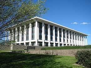
- High Court of Australia
- National Carillon
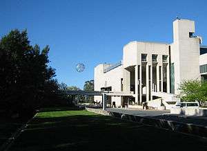
- National Library of Australia
- National Gallery of Australia
- National Portrait Gallery
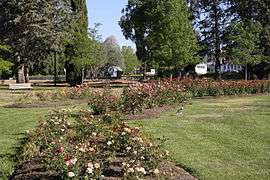
- National Rose Garden
- National Science and Technology Centre
- Old Parliament House
- Reconciliation Place
- Regatta Point
- West Block
Geology
The geology of Parkes has been studied in great detail. Canberra Formation, calcareous shale is found in the lower parts. This overlies middle Silurian Camp Hill Sandstone. The sandstone unconformably overlies the early Silurian Black Mountain Sandstone and State Circle Shale. State Circle Shale is Late Llandovery in a more finely divided time scale and it has been dated to 445 ±7 million years old. The State Circle Shale is composed of laminated shales and siltstone. Black Mountain Sandstone is composed of a white quartz sandstone.[6]
Education
Parkes residents get preference for:[7]
- Forrest Primary
- Telopea Park School (for high school)
- Narrabundah College
Gallery

 The Treasury building with Telstra Tower in the background.
See also
References
- Australian Bureau of Statistics (27 June 2017). "Parkes (state suburb)". 2016 Census QuickStats. Retrieved 28 June 2017.

- "Search for street and suburb names: Parkes". Environment and Sustainable Development Directorate. ACT Government. 4 December 2013. Retrieved 21 December 2013.
- Australian Bureau of Statistics (31 October 2012). "Parkes (SLA)". 2011 Census QuickStats. Retrieved 28 June 2017.
- Australian Bureau of Statistics (25 October 2007). "Parkes (SSC)". 2006 Census QuickStats. Retrieved 21 December 2013.
- Australian Bureau of Statistics (9 March 2006). "Parkes (SLA)". 2001 Census QuickStats. Retrieved 21 December 2013.
- Henderson G A M and Matveev G, Geology of Canberra, Queanbeyan and Environs 1:50000 1980.
- "Priority Enrolment Areas 2015 by Suburb" (Archived 14 February 2016 at the Wayback Machine). Education Directorate, Australian Capital Territory. Retrieved on February 8, 2016.