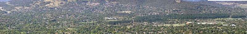
Fadden, Australian Capital Territory
Fadden is a suburb in the Canberra, Australia district of Tuggeranong. The postcode is 2904. The suburb is named after Sir Arthur Fadden, Prime Minister of Australia briefly in 1941.[2] It was gazetted on 5 August 1975.[2] Its streets are named after Queensland politicians.[2] It is surrounded by Macarthur, Gowrie and Wanniassa. It is bounded by Erindale Drive, the Wanniassa Hills Nature Reserve, Fadden Pine Plantation and Sternberg Crescent.
| Fadden Canberra, Australian Capital Territory | |||||||||||||||
|---|---|---|---|---|---|---|---|---|---|---|---|---|---|---|---|
 | |||||||||||||||
| Coordinates | 35°24′07″S 149°07′05″E | ||||||||||||||
| Population | 2,949 (2016 census)[1] | ||||||||||||||
| • Density | 951/km2 (2,460/sq mi) | ||||||||||||||
| Established | 1981 | ||||||||||||||
| Gazetted | 5 August 1975 | ||||||||||||||
| Postcode(s) | 2904 | ||||||||||||||
| Area | 3.1 km2 (1.2 sq mi) | ||||||||||||||
| District | Tuggeranong | ||||||||||||||
| Territory electorate(s) | Brindabella | ||||||||||||||
| Federal Division(s) | Bean | ||||||||||||||
| |||||||||||||||
Demographics
At the 2016 census, Fadden had a population of 2,949 people. The median age of people in Fadden was 44 years, an increase from 35 in 2001, compared to a median age of 35 for the ACT. The median weekly individual income for Fadden in 2016 was $1,197, up from $1,054 in 2011, $819 in 2006 and $600–$699 in 2001, compared to $917 for the ACT. The median weekly household income was $2,757 up from $1509 in 2006. In 2016, the median monthly housing loan repayment in Fadden was $2,299, up from $1517 in 2006.[1][3][4][5][6][7]
The residents of Fadden are predominantly Australian born, with 75.5% being born in Australia, compared to 76.5% in 2011, 75.3 in 2006 and 77.5% in 2001. In 2016 the three countries of birth for those born overseas were England, 4.8%, China, 1.4%, New Zealand, 1.1% and South Africa, 1.1% and India 1.0%. This compares to United Kingdom, 5.7%, New Zealand, 1.1%, and Croatia, 0.9% in 2001. The most popular religious affiliations in descending order are no religion, Catholic, Anglican and Uniting.[1][3][5][7]
Suburb amenities
Shops
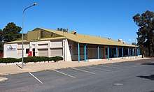
The Fadden local shopping centre is located on Hanlon Crescent and includes a hairdresser, a medical centre, a Chiropractor and massage therapist, and a veterinary hospital. Fadden's sporting facilities include the Fadden Neighbourhood Oval, at the back of the primary school, and tennis courts off Stopford Crescent. Two areas of the Canberra Nature Park are located in the suburb: Wanniassa Hills to the north of the suburb and the smaller Macarthur Hill in the east. Hannah Community Park straddles the border with Gowrie.[8] The Fadden Pine Plantation, a recreational area with substantial playground and barbecue facilities, is located between Isabella Drive, Bugden Avenue and Coyne Street. The Macarthur Scout Hall is located on Coyne Street.[9]
Education
Fadden Primary School is located on Hanlon Crescent. Fadden Primary caters for preschool and kindergarten to year 6.[10]
Transport
Several ACTION bus routes service Fadden. Routes 74 and 75 combine as a circular bus route which connects Fadden and surrounding suburbs with the Tuggeranong Town Centre and Erindale Centre.[11] Route 76 connects Fadden, Gowrie and Macarthur to Erindale Centre and Tuggeranong Town Centre.[12]
Geology

In the east, Fadden is built on Alluvium. The west of Fadden consists of Deakin Volcanics rhyolite. The rhyolite can be coloured green-grey, purple or cream, and dates from the Silurian age at 414±9 My. A fault heads north-north-west from Macarthur Hill with a quartz outcrop.[13]
References
| Wikimedia Commons has media related to Fadden, Australian Capital Territory. |
- Australian Bureau of Statistics (27 June 2017). "Fadden (State Suburb)". 2016 Census QuickStats. Retrieved 1 July 2017.

- Canberra's suburb and street names : origins and meanings. Department of the Environment, Land and Planning. 1992. p. 1. ISBN 1-86331-128-9.
- Australian Bureau of Statistics (19 November 2002). "Community Profile Series : Fadden (Statistical Local Area)". 2001 Census of Population and Housing. Retrieved 22 June 2006.
- Australian Bureau of Statistics (19 November 2002). "Community Profile Series : Canberra (Statistical Division)". 2001 Census of Population and Housing. Retrieved 22 June 2006.
- Australian Bureau of Statistics (25 October 2007). "Fadden (Statistical Local Area)". 2006 Census QuickStats. Retrieved 30 November 2007.
- Australian Bureau of Statistics (25 October 2007). "Canberra (Statistical Division)". 2006 Census QuickStats. Retrieved 30 November 2007.
- Australian Bureau of Statistics (31 October 2012). "Fadden (State Suburb)". 2011 Census QuickStats. Retrieved 15 February 2014.
- Planning and Land Management Group (July 2002). "Variation to the Territory Plan No 190" (PDF). Archived from the original (PDF) on 16 May 2009. Retrieved 15 February 2014.
- "Scouts and Scout Groups Clubs in Australia Capital Territory". ACT Scouts. Retrieved 15 February 2014.
- "Contact Us". Fadden Primary School. Retrieved 15 February 2014.
- Route 74 & 75 Transport Canberra
- Route 76 Transport Canberra
- Henderson G A M and Matveev G, Geology of Canberra, Queanbeyan and Environs 1:50000 1980.