Greenway, Australian Capital Territory
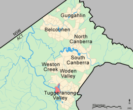
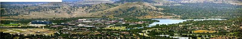
Greenway is a suburb in the Canberra, Australia district of Tuggeranong. The postcode is 2900. The suburb is named after the architect, Francis Greenway (1777–1837).[2] It was gazetted on 17 October 1986.[2] The streets are named after architects.[2] It includes the Tuggeranong Town Centre, Lake Tuggeranong and small residential areas on the northwestern and northeastern shores of the lake.
| Greenway Canberra, Australian Capital Territory | |||||||||||||||
|---|---|---|---|---|---|---|---|---|---|---|---|---|---|---|---|
 | |||||||||||||||
| Coordinates | 35°25′05″S 149°04′12″E | ||||||||||||||
| Population | 1,894 (2016 census)[1] | ||||||||||||||
| • Density | 357/km2 (926/sq mi) | ||||||||||||||
| Established | 1988 | ||||||||||||||
| Gazetted | 17 October 1986 | ||||||||||||||
| Postcode(s) | 2900 | ||||||||||||||
| Area | 5.3 km2 (2.0 sq mi) | ||||||||||||||
| District | Tuggeranong | ||||||||||||||
| Territory electorate(s) | Brindabella | ||||||||||||||
| Federal Division(s) | Bean | ||||||||||||||
| |||||||||||||||
It is next to the suburbs of Kambah, Wanniassa, Oxley, Monash and Bonython. It is bounded by Athllon Drive and Drakeford Drive. Behind the suburb is the Urambi Hills Nature Reserve and the Murrumbidgee River.
Population
In the 2016 Census, there were 1,894 people in Greenway. 57.2% of people were born in Australia. The next most common country of birth was India at 13.6%. 64.8% of people spoke only English at home. The most common responses for religion were No Religion 28.8%, Catholic 20.2%, Hinduism 13.4% and Anglican 10.1%.[1]
Geology
Greenway is built on top of Laidlaw Volcanics as is the west side of Tuggeranong. Rhyodacitic ignimbrite is in the form of grey rhyodacitic and dacitic crystal tuff of upper Silurian age. This kind of rock was formed from massive explosive volcanic eruptions that blasted a vast cloud of hot dust into the air. The explosion would have dwarfed the recent Mount St Helens eruption.[3]
Notes
- Australian Bureau of Statistics (27 June 2017). "Greenway (State Suburb)". 2016 Census QuickStats. Retrieved 29 June 2017.

- Canberra's suburb and street names : origins and meanings. Department of the Environment, Land and Planning. 1992. p. 60. ISBN 1-86331-128-9.
- Henderson G A M and Matveev G, Geology of Canberra, Queanbeyan and Environs 1:50000 1980.