Stirling, Australian Capital Territory
Stirling is a suburb of Canberra, Australian Capital Territory, Australia. It is located in the Weston Creek district.
| Stirling Canberra, Australian Capital Territory | |||||||||||||||
|---|---|---|---|---|---|---|---|---|---|---|---|---|---|---|---|
 | |||||||||||||||
| Coordinates | 35°20′56″S 149°03′00″E | ||||||||||||||
| Population | 2,134 (2016 census)[1] | ||||||||||||||
| • Density | 1,640/km2 (4,250/sq mi) | ||||||||||||||
| Established | 1970 | ||||||||||||||
| Postcode(s) | 2611 | ||||||||||||||
| Area | 1.3 km2 (0.5 sq mi) | ||||||||||||||
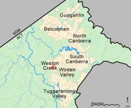
| District | Weston Creek | ||||||||||||||
| Territory electorate(s) | Murrumbidgee | ||||||||||||||
| Federal Division(s) | Bean | ||||||||||||||
| |||||||||||||||
The suburb is named after Sir James Stirling (1791–1865) who was the first Governor of Western Australia between 1829–1839 and established settlements at Perth and Fremantle in 1829.[2] The suburb was gazetted in 1970.[2] Its streets are named after Western Australian pioneers.[3]
Stirling contains the Weston Campus of the Canberra College, which is located on Fremantle Drive.
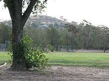
Stirling playing fields
Geology
Deakin Volcanics red-purple and green grey rhyodacite with spherulitic texture cover most of Stirling except for Laidlaw Volcanics pale to dark grey tuff on the southernmost quarter. Quaternary Alluvium covers the south west quarter.[4]
References
| Wikimedia Commons has media related to Stirling, Australian Capital Territory. |
- Australian Bureau of Statistics (27 June 2017). "Stirling (State Suburb)". 2016 Census QuickStats. Retrieved 1 July 2017.

- "Suburb Name search results". ACT Environment and Sustainable Development. Retrieved 14 February 2014.
- "Finding Aid: Suburbs and their Names" (PDF). Archives ACT. Retrieved 26 March 2020.
- Henderson, G. A. M.; Matveev, G. (1980). Geology of Canberra, Queanbeyan and Environs (Map). 1:50000.
This article is issued from Wikipedia. The text is licensed under Creative Commons - Attribution - Sharealike. Additional terms may apply for the media files.