Scullin, Australian Capital Territory
Scullin is a residential suburb in the Belconnen district of Canberra, located within the Australian Capital Territory, Australia. The suburb is named after Prime Minister of Australia James Henry Scullin. It was gazetted on 6 June 1968. In the city of Canberra, suburbs are assigned street names that reflect a distinct sub-group of cultural or historical Australian significance. The streets in the suburb of Scullin are named after aviators.[2] Scullin is located adjacent to the suburbs of Higgins, Florey, Page and Hawker. Southern Cross Early Childhood School and Scullin neighbourhood oval are located within the suburb. It is bordered by Kingsford Smith Drive, Belconnen Way, Southern Cross Drive and Chewings Street. Scullin is approximately 20 minutes walk and 5 minutes by car from the Belconnen Town Centre and 15 minutes walk and 3 minutes by car from the Hawker Shopping Centre. It is approximately 10 to 15 minutes by car from Canberra City and 30 minutes from Canberra Airport.
| Scullin Canberra, Australian Capital Territory | |||||||||||||||
|---|---|---|---|---|---|---|---|---|---|---|---|---|---|---|---|
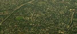 Aerial view of Scullin, from the west. | |||||||||||||||
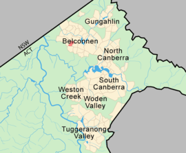 Scullin, shaded in pink. | |||||||||||||||
| Population | 2,929 (2016 census)[1] | ||||||||||||||
| • Density | 2,090/km2 (5,420/sq mi) | ||||||||||||||
| Established | 1968 | ||||||||||||||
| Postcode(s) | 2614 | ||||||||||||||
| Area | 1.4 km2 (0.5 sq mi) | ||||||||||||||
| District | Belconnen | ||||||||||||||
| Territory electorate(s) | Ginninderra | ||||||||||||||
| Federal Division(s) | Fenner | ||||||||||||||
| |||||||||||||||
Political representation
For the purposes of Australian federal elections for the House of Representatives, Scullin is in the Division of Fenner.[3]
For the purposes of Australian Capital Territory elections for the ACT Legislative Assembly, Scullin is in the Ginninderra electorate.[4]
Geology
Rocks in Scullin are from the Silurian age. Green grey rhyodacite of the Walker Volcanics underlie the south and center of the suburb. North of center is purple and green-grey dacite of the Walker Volcanics that was deposited before the rhyodacite. A strip along the far north east has pink rhyolite from the Deakin Volcanics. Purple pink rhyolite from the Deakin Volcanics is in the north west of the strip.[5]
Education
Scullin residents get preference for:[6]
- Southern Cross Early Childhood School
- A shared Priority Enrolment Area (PEA) of Florey Primary, Hawker Primary, and Weetangera Primary
- Belconnen High School
- Hawker College
References
| Wikimedia Commons has media related to Scullin, Australian Capital Territory. |
- Australian Bureau of Statistics (27 June 2017). "Scullin (State Suburb)". 2016 Census QuickStats. Retrieved 29 June 2017.

- "Suburb Name search results". ACT Environment and Sustainable Development. Retrieved 12 February 2014.
- "Profile of the electoral division of Fenner (ACT)". Current federal electoral divisions. Australian Electoral Commission. 8 February 2016. Retrieved 29 May 2016.
- "Electorates 2012 election". Electorates. ACT Electoral Commission. 5 July 2012. Retrieved 17 December 2013.
- Henderson G A M and Matveev G, Geology of Canberra, Queanbeyan and Environs 1:50000 1980.
- "Priority Enrolment Areas 2015 by Suburb" (Archive). Education Directorate, Australian Capital Territory. Retrieved on February 8, 2016.